This article was originally pubished at 12:09 a.m.
VILONIA — 9:40 a.m. Gov. Mike Beebe said authorities believe they have accounted for everyone in Vilonia and the death toll there is expected to remain at four, though he cautioned that there were no guarantees.

Beebe, speaking in a shopping center parking lot off Highway 64 after touring the damaged Faulkner County town, said he will likely declare a disaster in the next day or so.
He also praised the responders who have been going door-to-door in Vilonia and elsewhere in the aftermath of a storm system that killed eight people across the state.

"We've gotten too good at this disaster response because we've had so many disasters," Beebe said. "We're glad we're good at it. We're not glad that's the reason why we are."
Beebe said he had no information about the four people who died in Vilonia. Officials earlier said two were found in a tractor trailer and two others died when their mobile homes were destroyed.
It's still not clear if one or multiple tornadoes tore through Vilonia, but Beebe said a large area of damage was left behind.
"If it was one tornado, it appears to be extremely wide," he said.
The immense damage makes Vilonia fortunate not to have more fatalities, Beebe said.
8 a.m. — Authorities in Vilonia have begun a new door-to-door search for people injured or killed by Monday night's tornado.
Faulkner County Sheriff's Office Lt. Matt Rice said officials with local agencies and those from other parts of the state were canvassing the damaged area, trying to account for all of the city's residents.
A preliminary search was conducted in the immediate aftermath of the storm, but Rice said that was hampered by downed power lines, debris and darkness.
Four people have been confirmed killed in the storm, which officials say packed winds reaching 120 mph.
"I'm hoping we don't have anymore (fatalities)," Rice said. "But I can't promise that. You see the damage."
Rice said he had no information on the number of people injured and said he didn't know if there was any specific number of people who were still unaccounted for.
He said the tornado left a wide path of destruction stretching from Saltillo to Vilonia.
The http://www.arkansas…">storm gallery showing Monday's damage will be updated throughout the day.
6:14 a.m. — Authorities say four people have been confirmed killed in Vilonia in a tornado that packed high winds and left behind devastating damage.
Two people were found dead in the Faulkner County town Monday night after the powerful storm ripped across the state. County spokesman Stephan Hawks said two additional victims were found early Tuesday morning.
More than 50 people were said to be unaccounted for Monday night and crews were preparing as day broke to continue going door-to-door through the damaged community.
"It's horrible," Hawks said, standing near a Harps store on Highway 64 that had large metal debris lining its parking lot. " Its horrible for the people of Vilonia. It's a good tight-knit community. But it makes it hard when they get wave after wave of weather ... It's a devastating event."
Hawks said two of the storm victims in Vilonia were found in a tractor trailer and two others were in manufactured homes that were destroyed by the storm.
He said the tornado has not been confirmed by the National Weather Service, but that officials believe it packed winds reaching 120 mph as it tore a 3-mile wide gash of damage through the city. He said a significant portion of Vilonia had at least some damage.
12:26 A.M. — A fire chief in the central Arkansas town where two people died after storms devastated the area says between 50 and 60 people are unaccounted for.
Vilonia fire chief Keith Hillman says between 50 and 60 people remained unaccounted late Monday night. Emergency officials say two people have died there, though it wasn’t immediately clear how.
Hillman says fire crews were wrapping up work overnight and intend to resume work at 7 a.m. Tuesday.
Emergency officials in northwest Arkansas say three other people have died in storm-related deaths when floodwaters swept two vehicles off the road. One woman died in Washington County and a man and a woman died in Madison County.
------------------------------------------
12:09 A.M. — Emergency officials in Arkansas have confirmed three more storm-related fatalities, bringing the death toll to five statewide.
Arkansas Department of Emergency Management spokesman Tommy Jackson says two people have died Monday in the central Arkansas town of Vilonia, where a tornado likely ripped through the area.
In northwest Arkansas, emergency officials say a man and a woman died after floodwaters swept their car off the road in Madison County and another woman died near after her car was swept off the road in Washington County.
That woman’s 11-year-old son survived.
------------------------------------------
10:59 P.M. — An elderly couple was reportedly dead in Madison County after floodwaters carried away their vehicle, a Northwest Arkansas news site said.
The Madison County sheriff told 4029tv.com that the two were found inside the vehicle late Monday about 12 miles south of Huntsville on Highway 23.
------------------------------------------
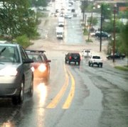
10 p.m. -Another severe weather system wreaked havoc in Arkansas on Monday, including deadly flash floods, and multiple storms packing high winds and possible tornadoes. Power was knocked out to nearly 100,000 customers.
Most of the state was under a flash food warning as the storm marched its way east toward Tennessee.


A West Fork woman died earlier Monday when she got out of her van, which was being swept away in Washington County floods. Her 11-year-old son survived.
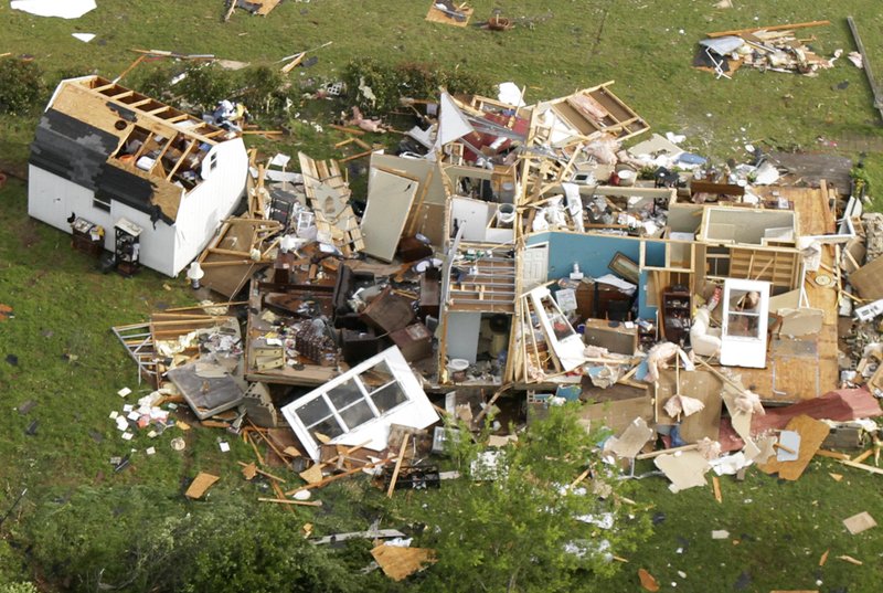
Another fatality was seen in hard-hit Vilonia, where there are reports of a half-mile wide swath of damage.
Several injuries were reported, as several storm fronts sprang up from Hot Springs Village to Vilonia in the span of two hours. Damage reports were coming in from all over, including roofs torn off of housing at the Little Rock Air Force Base and trees and power lines knocked down in many areas.
Rescuers were out to help clear debris and checking on residents.
Gov. Mike Beebe issued a state of emergency retroactive to April 19 for the entire state.
Severe storms have been plaguing the state since April 15, when an overnight system left seven dead.
------------------------------------------
9:56 P.M. — North Pulaski High School in Jacksonville has sustained damage in storms that raked the state Monday night.
The high school will not be in session tomorrow.
School officials are assessing damage.
Arnold Drive Elementary also has canceled classes for Tuesday because of power loss.
The windows reportedly were blown out at the Arkansas Repertory Theatre in Little Rock.
ASU-Beebe was also to be closed Tuesday.
------------------------------------------------------
9:22 P.M. — Utility officials say more than 75,000 homes and businesses are without electricity as severe thunderstorms race across Arkansas.
A woman was killed in Washington County flooding, and several people were reported injured in Monday’s storms, and damage was reported to be widespread in Garland County in the western part of the state.
Entergy Arkansas reported 75,439 power failures in all, including 21,131 in Garland County and 18,498 in Pulaski County.
Emergency management officials say the storms left downed power lines and trees in their wake.
Tornado warnings were issued for numerous counties in western Arkansas and warnings continued into the Little Rock area.
On the Little Rock Air Force Base near Jacksonville, high winds tore roofs off of base housing units.
------------------------------------------------------
9:12 P.M. — A woman was swept to her death Monday afternoon when floodwaters swept her minivan off a roadway in southern Washington County.
Kelly Cantrell of the Washington County sheriff’s office said the victim tried to cross water flowing across Arkansas 265 when she was swept into the Illinois River. The woman’s 11-year-old son survived.
The dead woman was identified as 38-year-old Consuelo Santillano of West Fork.
Cantrell said the woman’s minivan stalled in the water and was swept into the stream. The spokesman said Santillano got out of the van and that the her body was found about 150 yards from the vehicle.
THV has reported that a relative of one of its employees is trapped under a vehicle in Vilonia.
------------------------------------------------------
8:50 P.M. — Several injuries were reported in Faulkner County as storms packing possible tornadoes plowed through the state Monday night.
Officials were investigating a report of people trapped in a mobile home on Walnut Valley Road off Highway 7 in Garland County.

A powerful storm was threatening White County.
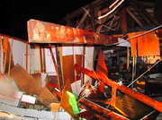
Mount Pilgrim Baptist Church was extensively damaged.
Trees and powerlines were down in Beebe.
Heavy rains and high winds were racing toward Pine Bluff in south Arkansas.
------------------------------------------------------
8:33 P.M. — Gov. Mike Beebe declared a statewide State of Emergency as possible tornadoes caused extensive damage and injuries.
A spokesman for Beebe said Monday the state of emergency will be retroactive until April 19 when the last batch of storms whipped across Arkansas.
Forecasters say Tuesday could bring another bout of bad weather and that storms could delay assessment of Monday’s damage.
Beebe spokesman Matt DeCample says the state won’t likely know the extent of damage caused by Monday’s flooding and tornadoes until Tuesday or Wednesday.
A tornado warning was in effect for White County until 9 p.m.
Witnesses said trees had fallen on several houses in Cammack Village.
Damage has been reported in Oak Grove.
------------------------------------------------------
8:15 P.M. — Severe storm systems spawned possible tornadoes throughout central Arkansas on Monday night.
Arkansas State Police reported people were trapped in a house on Roach Circle on Highway 270 w in Hot Springs
A storm packing high winds and a possible tornado was heading toward Cabot and was about to cross the county line into Lonoke County.
Trees and powerlines were down near Cammack Village.
Several roofs were blown off houses at the Little Rock Air Force Base.
Another storm was threatening Cleburne County.
A flash flood watch has been issued for most of central Arkansas.
Forecasters said damage was reported at Morgan and Maumelle along Interstate 40 northwest of Little Rock and also at Vilonia, north of the Arkansas capital.
Another storm was bearing down on Little Rock’s northeastern suburbs just after night fell.
The Storm Prediction Center had predicted significant severe weather over much of Arkansas for Monday, and storms quickly grew violent in the heat of the day. Forecasters say Tuesday could bring another bout of bad weather.
Extensive damage was reported in Vilonia, with cars flipped over and trees crossing 365.
A tornado warning was in effect for Lonoke and Prairie counties.
------------------------------------------------------
7:50 P.M. — A possible tornado was spotted near the airport in North Little Rock, moving toward the Little Rock Air Force Base.
Another tornado was reported in White County.
A church was reportedly damaged on Interstate 40 near Maumelle.
Near Mayflower, Highways 365 south and 89 south are blocked by storm debris.
A police officer said cars had blown off the road and trees were knocked down between Morgan and Mayflower.
Structural damage was reported in Vilonia from a possible tornado.
An emergency official in central Arkansas’ Garland County says people are trapped in cars and homes as a batch of severe storms fling high winds and heavy rain across the state.
The Perry County sheriff said there were no injuries or deaths to report in his area, although there was an apparent tornado that knocked down several trees.
Two residences and a church were damaged.
Heifer Ranch appeared unharmed, according to reports, with some scattered debris
------------------------------------------------------
7:31 P.M. — Downtown LIttle Rock was in the path of another dangerous storm front as damage and injuries were reported Monday in central Arkansas.
In Faulkner County, a possible tornado was reported near Vilonia.
A tornado warning was in effect until 7:45 p.m. for Faulkner, Lonoke, Pulaski and Saline counties.
------------------------------------------------------
7:15 P.M -An emergency official in central Arkansas’ Garland County says people are trapped in cars and homes as a batch of severe storms fling high winds and heavy rain across the state.
A wall cloud was seen at Napa Valley in west Little Rock, while another system with possible rotation had moved through Perry County.
Three injuries have been reported, two in Sunshine in Garland County and one on Interstate 40.
Emergency management coordinator Joy Sanders said Monday the storms flipped over several mobile homes and dumped more than a foot of water on some roads in Garland County.
There weren’t any immediate reports of injuries.
In southwest Arkansas, a Pike County emergency official says the storms lifted the roof off a home, washed pavement off roads and yanked down power lines. A suspected tornado also tore through a wooded area of Polk County in western Arkansas.
The National Weather Service has issued several tornado warnings and forecasters say the storms are expected to wane overnight before another round Tuesday.
------------------------------------------------------
Arkansas was again facing severe weather, with thunderstorms and possible tornadoes pummeling most of the state Monday.
A tornado on the ground has been reported by several witnesses in Hot Springs.
The storms left thousands without power across the state, including more than 4,000 in central Arkansas’ Garland County, according to estimates from Entergy Arkansas, the state’s largest electric utility.
Possible rotation has been spotted in Menifee and near Toad Suck, close to Conway.
Witnesses say a tornado has done damage in Jessieville.
A suspected tornado tore through a wooded area of Polk County, while residents in the northwest part of the state contended with flooded roads. In northeast Arkansas, several rivers left their banks, flooding mainly farmland but prompting City Hall in Hardy to evacuate ahead of the Spring River’s crest.
As evening approached, the National Weather Service issued a number of tornado warnings across Arkansas as a line of big storms worked eastward across the state.
Deputies in Polk County found downed and twisted trees near the tiny communities of Board Camp and Big Fork, a sheriff’s dispatcher said. One home had been crushed by a tree and deputies checked to see if anyone was inside, but the damage mainly went through timberland.
Damage from either a tornado or strong winds was reported in Garland County. A motor home was knocked over on its side on Ragweed Valley Road. Limbs had fallen on Powell Road, Oates Loop and Brady Mountain Road.
The National Weather Service in Little Rock issued a tornado watch until 11 p.m. for 51 Arkansas counties. They include: Baxter, Boone, Bradley, Calhoun, Clark, Cleburne, Cleveland, Columbia, Conway, Dallas, Faulkner, Fulton, Garland, Grant, Hempstead, Hot Spring, Howard, Independence Izard, Jackson, Jefferson, Johnson, Lafayette, Lawrence, Little River, Logan, Lonoke, Marion, Miller, Montgomery, Nevada, Newton, Ouachita, Perry, Pike, Polk, Pope, Prairie, Pulaski, Randolph, Saline, Scott, Searcy, Sevier, Sharp, Stone, Union, Van Buren, White, Woodruff and Yell counties.
About 20 miles northeast of Fayetteville, historic War Eagle Mill had flooded, as had an access road to the working grist mill. The first mill was built on the site in 1832 and the present version is the fourth to have been built there. In 1848, the mill was washed away in a flood.
The potentially dangerous storms could produce tornadoes and flash flooding.
Washington County has issued a disaster declaration because of damage caused by flooding.
County Judge Marilyn Edwards issued the declaration Monday based on damage from flooding last week. The declaration notes that more heavy rain is expected and with it, more flooding.
The declaration can help the county get aid to fix roads and other infrastructure.
A spokesman for Gov. Mike Beebe said it was too early for the state to make any emergency declarations, though a number of counties had already done so, based on the rains of the previous days. Beebe spokesman Matt DeCample said the state is in an unusual position because the forecast for Tuesday called for more strong storms and heavy rains, which could delay assessment of Monday’s damage.
State police in Springdale say Monday’s rains have brought flash flooding but not many traffic accidents.
Forecasters are predicting that the storms will last through Wednesday, with the first system ramping up Monday evening and a second one moving across central Arkansas in the overnight hours of Tuesday.
The Little Rock sales tax meeting has been canceled because of the weather.
In Hardy, homes along the Spring River were evacuated and Mayor Nina Thornton says floodwaters were expected to reach City Hall, so workers were evacuating there, too.
“We just got back in after the last flood,” Thornton said.
The homes along the flood prone Spring River are mainly vacation homes that are elevated on pilings, though the floodwaters predicted to reach their doorsteps, Thornton said. The city began moving people out on Sunday and the effort continued Monday morning. Thornton said flood waters covered the roads along the river, so no one could get back into the area by midmorning.
The river was forecast to crest Tuesday at 21 feet, which would be enough to put six inches of water in City Hall, Thornton said. The mayor says the city has flood insurance for the building.
In 2008, the Spring River crested at 22 feet, which flooded the Old Town district and City Hall. The weather service considers an 18 foot crest on the Spring River as a “life-threatening situation.”
Nearby at Ravenden Springs, flood waters from the Eleven Point River covered roadways and low-lying fields.
The Black River reached flood stage of 14 feet on Sunday, with a projected Tuesday crest of 29 feet, which will flood state highways and other roads in Black Rock, Jacksonport and Powhattan. Croplands also will flood.
The Buffalo National River is forecast to crest at 29 feet at St. Joe, which will bring flood waters to camp sites at Tyler Bend, a popular point for launching canoes and kayaks on the scenic waterway.
At Van Buren in far western Arkansas, the Arkansas River reached flood stage of 22 feet Monday, with a crest of 25 feet forecast Tuesday, which will result in flooding of agricultural lands.
A severe thunderstorm in southwest Arkansas on Monday morning prompted a tornado warning and knocked down utility poles near DeGray Lake along Arkansas Highway 7.
The National Weather Service said Monday that a storm system in the southern Plains would move toward Arkansas, touching off the next round of severe thunderstorms in late afternoon and evening.
Another storm system is forecast to reach Arkansas on Tuesday, bringing more severe weather, with some areas getting 3 to 6 inches of rain. That will be on top of as much as 10 inches of rain that some parts of northwest Arkansas got over the past several days.
The weather service said flash flood warnings are likely to be posted for numerous areas as the storm systems move through.
Rain is forecast to continue into Wednesday, after which a couple of days of calm weather are to follow.
Tornadoes from a storm system on April 15 left seven people dead across the state, and several other severe weather events have been felt since.
On Saturday, a tornado hit southern Newton County. Then on Sunday, a storm hit Scott, Logan and Yell counties, producing baseball-sized hail at Mount Magazine.
RELATED: Storms maul state, kill 5
Information for this article was contributed by Chuck Bartels of The Associated Press.