LITTLE ROCK — The National Weather Service issued a tornado warning for Lonoke County for a radar-indicated tornado shortly after 5 p.m. Thursday. At about the same time, a tornado warning went up for far northeastern Arkansas in Clay and Greene counties.
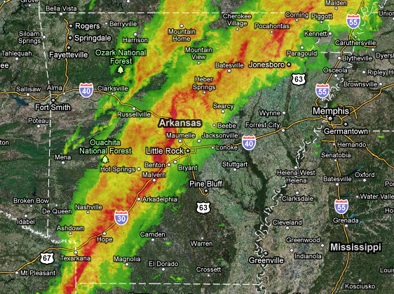
The line of storms stretched from southwestern Arkansas to Piggott.
Lightning struck the state Capital building twice as the storm passed over Little Rock.
Thousands of power failures were reported in central Arkansas after severe thunderstorms moved through.
Entergy spokesman James Thompson says some 3,000 are without power in Little Rock alone. More power failures are expected as the storm moves eastward.
A possible tornado was spotted near Perryville as a severe weather stormed into central Arkansas on Thursday afternoon.
Radar-indicated rotation prompted the warnings, causing sirens to sound throughout the metropolitan area as 5 p.m. approached.
The Pulaski County sheriff's office reported power lines and trees down at Higginbotham Road in western Pulaski County near the Perry County line, Crystal Valley Road between Colonel Miller and Raines Roads and Craig Road near Willow Beach.
National Weather Service Doppler radar indicated a severe thunderstorm near Lake Winona, 16 miles south of Perryville around 4 p.m.. The National Weather Service issued a tornado warning between Little Rock and Conway for radar-indicated rotation. There was no initial report of a tornado on the ground.
The storm was pushing east and had already left damage in is wake. The Garland County sheriff’s office said Thursday afternoon that trees were down near Elmwood and that power was out in part of Hot Springs.
Trees and power lines were reported down in the area of Lonsdale in Saline County.
Trees and power lines are also down near the Saline County line around Lonsdale.
A tornado watch is in effect for most of Arkansas as a line of severe weather approaches from the west.
The National Weather Service says the entire state is at risk of seeing at least a severe thunderstorm. The area most at risk is south and east of a line from Mena to Hot Springs to Searcy.
The weather service says the storm system is bringing strong low- and mid-level winds and that conditions are right for tornadic thunderstorms to form. Heavy rains are possible in north-central and northeast Arkansas.
The high temperatures and unstable atmosphere make the threat of severe weather even stronger. The cold front should clear the Mississippi River around midnight, and from early evening until then, there is the possibility of severe weather.
A flash flood watch is in effect for eastern Arkansas.
The system should reach central Arkansas between 3 p.m. at 6 p.m. and should hit the eastern part of the state between 6 p.m. and 9 p.m.
Information for this article was contributed The Associated Press.