LITTLE ROCK — As the water in the Mississippi River continues to rise toward predicted historic levels, comparisons with the great flood of 1927 have become inevitable.
At a section of Interstate 40 now closed because of high water, scientists announced that the current river levels have not been seen since that flood 84 years ago.
The flooding has gotten so bad that detour routes are now being detoured. Back roads used to channel traffic around the closed section of I-40 are now underwater in places, and new detour routes have been devised.
But levees and other flood defenses built over the years make it unlikely that any major metropolitan areas will be completely inundated as the water pushes downstream and into tributaries over the next week or two, engineers say.
Farms, small towns and even some urban areas, however, could see extensive flooding.
“It’s going to be nasty,” said Bob Bea, a civil engineer at the University of California, Berkeley.
How bad it gets depends on how well the flood-protection systems have been built and maintained, Bea said.
Desha County Judge Mark McElroy said rumors about levee breaks and devastating flooding along the Mississippi River provoked him to hold town hall-style meetings this week.
So many people showedup at an Arkansas City meeting that McElroy said he had to move it from City Hall to the building’s back lawn.
“You can see panic in their eyes,” McElroy said. “When you hear those rumors - and some of them heard the stories of the ’27 flood - they are concerned, should be concerned. But not panicked.”
On Friday, Chris Masingill, co-chairman of the federal Delta Regional Authority, was asked at a Little Rock conference how the current flood compares with the 1927 flood.
“I think in pockets we’re going to see some significant damage estimates,” Masingill said. “I don’t throughout the entire region, but in some areas it will be enormous.”
As he spoke, mandatory evacuations in Woodruff County were ongoing.
Traffic along Interstate 40 - 23 miles of which have been closed between Hazen and Brinkley in both directions because of water - was rerouted. More than 30,000 vehicles travel on I-40 each day, officials said.
Sixteen cities and towns in Arkansas have experienced flooding, Arkansas Department of Emergency Management officials said. Twentyfour have issued voluntary or mandatory evacuation orders.
In St. Francis County, which stretches close to the Mississippi River, officials requested 56,000 sandbags Friday.
And in Memphis, police went door-to-door in low-lying areas, warning residents to leave. Emergency workers handed out bright yellow fliers in English and Spanish that read, “Evacuate!!! Your property is in danger right now.”
INTERSTATE 40
Part of I-40 will remain closed at least through the weekend as water from the White River continues to overrun lanes east of Hazen, state officials said Friday.
Floodwaters also forced state officials to revise detour routes Friday afternoon after Arkansas 1 was closed.
Water overran Arkansas 1, closing the White River bridge near the Arkansas and Monroe county lines, Arkansas Highway and Transportation Department spokesman Glenn Bolick said.
“Obviously this was not water backing up from Mississippi. It was water that’s been flowing down from Independence and Jackson counties earlier in the week and ... there’s just not enough room for this massive amount of water to go under the freeway,” Bolick said regarding flooding on I-40.
The closure prompted officials to create three detour routes for eastbound traffic: One for cars and two for big trucks, Bolick said.
Eastbound traffic will exit at Hazen and divert south to Stuttgart, where cars will be routed east along U.S. 79 and then north on U.S. 49 through Monroe County and back to I-40 at Brinkley, he said.
The change cut the detour for cars in half, from 120 miles to about 65 miles, Bolick said.
Trucks will be diverted starting at Stuttgart either south on U.S. 165 to U.S. 65 at Dumas or along U.S. 79 southwest to Pine Bluff. There, drivers can take U.S. 65 to Dumas.
The full detour route for Memphis-bound big trucks is about 300 miles through south Arkansas and back north through Mississippi, Bolick said.
Westbound traffic will still be rerouted north at exit 216 near Brinkley north on U.S. 49 and then west on U.S. 64 through Woodruff County. The detour sends traffic south on U.S. 67 at Bald Knob to Little Rock.
Emanuel Banks, assistant chief engineer for operations at the Highway Department, said workers won’t know whether the flooded roads have been damaged by the onslaught until the water has receded.
Near Stuttgart on Friday, a convoy of 18-wheelers was visible from miles away as it rounded the sharp turn on U.S. 165 en route to DeWitt from Hazen.
Traffic moved slowly but steadily.
“We’re gonna get there eventually,” Ken Sanders of Oklahoma, who was heading to Kentucky to visit his family, said as he stopped to fill up at a gas station just off exit 193. “This is a big pain in the butt.”
Sam Johnson, a long-haul trucker from Oregon en route to New York with a load of electronics called the detour a hindrance but welcomed the chance to see “some new country.”
“I’ve never been this way before,” he said.
THE ’27 FLOOD
In the first few months of 1927, the Mississippi River and its tributaries flooded more than 16 million acres in seven states - 5 million of them in Arkansas.
That flood left 700,000 people homeless, about half of them Arkansans. Towns all along east Arkansas were devastated. Crops were lost and businesses demolished when the water tore through the Delta.
The flood prompted the first national effort to control flooding using a series of dams, levees and reservoirs.
The National Weather Service said that in some cities, the Mississippi and White rivers are expected to crest over the next two weeks at or near their crest levels in 1927.
But John Barry, the author of Rising Tide: The Great Mississippi Flood of 1927 and How it Changed America, said that doesn’t mean those cities will again see the kind of flooding experienced in 1927.
Barry said there is a “significant gap” in the “official” U.S. Army Corps of Engineer 1927 flood levels and the higher levels that military and civilian engineers saw on the ground.
“The amount of water in the river in ’27 is considerably greater than it is today. But there’s still a hell of a lot of water in the river,” said Barry, adding that the current flood is one of the biggest in the Mississippi River’s history.
The capacity of the flood protection system still is above the maximum predictions of this flood, added Barry, who sits on the New Orleans levee board.
He said major floods over the past 60 years exposed weaknesses that have been addressed.
“There is certainly going to be flooding - backwater flooding - but there’s no reason to expect the levee to breach on the Mississippi River,” Barry said.
“If that were to happen, then you’re in serious trouble. You may as well have 1927. Once a breach occurs, there is no technology we have available [that could stop it].”
‘CAN’T BELIEVE THIS’
The Coast Guard closed a 5-mile stretch of the swollen Mississippi River for a time Friday to protect Caruthersville, Mo., and said barges could be banned for up to eight days. The fear was that the wake from big boats would push water over a flood wall and into the town of 6,700 people.
Lynn Muench, a vice president of the American Waterways Operators, an industry group, said the eight-day shutdown will have a multimillion-dollar effect.
John Knoll, president of Knoll Feed Transportation in Stuttgart, said the holdup in barge traffic has prevented some of his trucks from picking up loads.
And with the river continuing to rise, “we won’t be back to normal for quite a while,” Knoll said.
Bob Nations, director of emergency management for Shelby County, which includes Memphis, said there was still time for residents to seek higher ground, The Associated Press reported.
The river is not expected to crest there until Wednesday.
About 950 households in Memphis and about 135 other homes in Shelby County were getting notices urging residents to leave.
“This does not mean that water is at your doorstep,” Nations said of the door-to-door effort.
“This means you are in a high-impact area.”
Jeanette Twilley of south Memphis returned home to find one of the yellow notices on her door. Her house is roughly 75 yards from the overflowing Nonconnah Creek, which has flooded three houses on her street.
“Amazed. Amazed. I just can’t believe this,” said Twilley, who planned to evacuate. “There’s not going to be anybody here.”
Water pooled at the lowest end of Beale Street, the thoroughfare synonymous with Mississippi blues, but the area is about a half-mile from the street’s world-famous nightspots.
ARKANSAS DEVELOPMENTS
In Woodruff County on Friday, 100 Arkansas National Guardsmen helped evacuate residents after water threatened to spill over local levees.
One levee of concern is south of Augusta near the Woodruff and Prairie county line, state officials said. Residents of Cotton Plant, Gregory, McClelland and Patterson were asked to leave their homes as a precaution.
About 1,000 people live in those four communities.
Woodruff County Judge Charles Dallas said evacuations were going smoothly.
“I couldn’t be happier with the way everyone has stepped up during this,” Dallas said.
He said river levels were beginning to fall slightly in Augusta. The White River was at just over 40 feet and was expected to fall to over 39 feet by this morning.
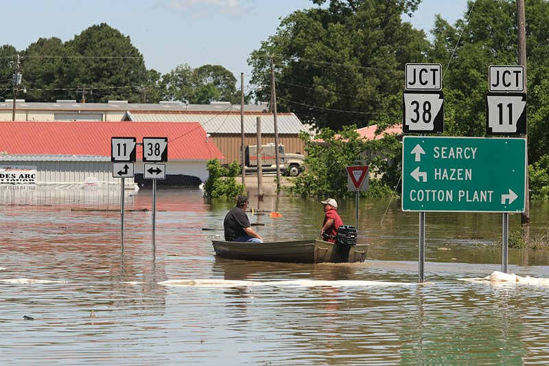
In nearby Prairie County - where 100 to 200 homes have been flooded - residents of Des Arc and DeValls Bluff continued to watch the White River inch higher.
The river level at Des Arc was at 39.29 feet and was expected to crest at 40 feet today.
Residents stacked sandbags around homes and businesses, said Davis Bell, spokesman for the Prairie County Office of Emergency Management.
Many of DeValls Bluff ’s 700 residents have left, but as in Des Arc, those who remained were volunteering in flood-relief efforts.
Meanwhile, the Lonoke County sheriff’s office found the body Friday of a man missing since Tuesday.
The body of Carl Hess, 55, was found about 150 feet from where authorities found his truck off Arkansas 236 on Tuesday afternoon, said sheriff’s office spokesman Lt. James Kulesa.
Still missing in Randolph County was Jana Chastain, 31, whose sport utility vehicle was found Thursday submerged in water behind a home in Shannon, south of Pocahontas, the AP reported.
Farther south in Desha County, McElroy had more community meetings planned.
“Right now, everything is fine,” he said. “I think we need to take a deep breath.”
To punctuate his point, McElroy said he jokingly showed up at the Arkansas City town hall meeting in a life jacket.
But he acknowledged that he was a little worried about what will happen over the next several days - and that there is little he can do about it.
“I tell people, ‘I’m the county judge. I didn’t part the Red Sea, and I can’t stop the Mississippi,’” he said. “But the man who parted the Red Sea can, so I suggest you pray.” Information for this article was contributed by Charlie Frago, Claudia Lauer, Kenneth Heard, Debra Hale-Shelton and Laurie Whalen of the Arkansas Democrat-Gazette; and Adrian Sainz and Cain Burdeau of The Associated Press.
Road closings The list below shows Arkansas roads closed because of high water or washouts as of Friday afternoon. Up-to-date listings can be found under “fl ood information” at www.arkansashighways.com Road Location ARKANSAS COUNTY Ark. 17 Mile 9.89 to 12.0 near Ethel Ark. 144 Mile 0.20 to 1.08 near Gillett Ark. 146 Section 1A west of Preston Ferry BENTON COUNTY Ark. 264 Section 1 east of Bethel Heights CARROLL COUNTY Ark. 187 Section 0A at Beaver CLAY COUNTY Ark. 211 Missouri line to Ark. 67 CONWAY COUNTY Ark. 95 Mile 8.20 at St. Vincent Ark. 95 Mile 2.85 north of Morrilton Ark. 113 Mile 7 near Blackwell Ark. 124 Mile 1.6 at Cleveland Ark. 247 Mile 0.25 at Devils Creek CRAIGHEAD COUNTY Ark. 91 Section 2A to the Lawrence Co. line near Egypt Ark. 158 Intersection of Ark. 139 to Mississippi Co.
Ark. 226 Between Cash and Ark. 67 Ark. 230 At Bono CRITTENDEN COUNTY Ark. 42 Mile 2 near Three Forks Ark. 118 Mile 12.4 at Earle Ark. 184 Mile 2.9 CROSS COUNTY Ark. 163 Two miles south of U.S. Ark. 64 at mile 0.15 near Levesque GREENE COUNTY Ark. 139 Ark. 412 to Mounds INDEPENDENCE COUNTY Ark. 14 Mile 1.2 to 5.81 east of Oil Trough Ark. 37 Ark. 122 to Jackson Co.
Ark. 69 Ark. 122 to Jackson Co.
JACKSON COUNTY Ark. 14 Mile 0 to 4.80 near Ingleside Ark. 18 Mile 4.9 spur to Poinsett Co.
Ark. 18 Mile 2.4 to 4.2 at Newport Ark. 37 Mile 5.5 to 6.48 Ark. 37 Mile 0 to 7.96 near Tuckerman Ark. 69 Mile 0 to 4.05 near Jacksonport Ark. 224 Mile 0 to 8.25 at Tuckerman Ark. 226 Ark. 17 to the end of state maintenance LAWRENCE COUNTY Ark. 25 Between Black Rock and Powhatan Ark. 228 Mile 0 to 4.50 at Clover Bend Ark. 412 Section 6A west of Walnut Ridge LEE COUNTY Ark. 78 Mile 0 to 4.30 near Aubrey Ark. 121 Mile 7.5 at Marianna Ark. 243 West of Ark. 121 near Rondo LONOKE COUNTY Ark. 13 5 miles north of Carlisle MISSISSIPPI COUNTY Ark. 118 Mile 0 to 2.75 at Joiner Ark. 120 Between Tuckertown and O’Donnell Bend Ark. 158 Mile 0 to 3.0 at Mandalay Ark. 198 From the Mississippi River levee to the end of state maintenance MONROE COUNTY Ark. 86 Section 3 east of Holly Grove Ark. 302 Mile 0 to 6.5 near Clarendon OUACHITA COUNTY Ark. 7 From Camden to Sparkman PHILLIPS COUNTY Ark. 20 Mile 13, east of Elaine Ark. 20 Mile 18 at Helena Ark. 318 Ark. 316 to Ark. 20 POINSETT COUNTY Ark. 214 Fisher to mile 3.14 PRAIRIE COUNTY I-40 Westbound at the 202 mile marker I-40 Eastbound at the 201 mile marker Ark. 11 From I-40 to Ark. 38 Ark. 33 South of Ark. 38 at Des Arc Ark. 38 Mile 16.96 to 20.35 at Des Arc Ark. 38 Jct Ark. 11 south of Searcy and north of Des Arc Ark. 38 Jct Ark. 11 at mile 3.99 Ark. 70 West from Ark. 33 to the White River bridge toward DeValls Bluff RANDOLPH COUNTY Ark. 67 Ark. 304 to Lawrence Co.
Ark. 90 Ark. 67 to Okean Ark. 166 Stokes to Ark. 67 Ark. 304 Between Ark. 67 and Ark. 231 ST. FRANCIS COUNTY Ark. 50 Mile 0.5 north of Madison Ark. 50 Mile 1.0 WHITE COUNTY Ark. 36 Mile 8.03 east of West Point WOODRUFF COUNTY Ark. 33 1.8 miles north of Augusta SOURCE: Arkansas Highway and Transportation Department Arkansas Democrat-Gazette
Front Section, Pages 1 on 05/07/2011