LITTLE ROCK — Arkansans dreaming of a White Christmas may be onto something this year.
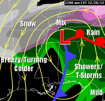
Snow won't be on the ground or even falling by Christmas morning, but various forecast models agree that a system could usher in wintry precipitation by the late afternoon or early evening, National Weather Service meteorologist Charles Dalton said.
"The likelihood of snow Tuesday evening somewhere in the state is pretty decent," said Dalton, who works in the agency's North Little Rock office. "It's hard to say it's 80 percent or anything that high. But the models have been pretty consistent showing snowfall in some part of the state."
The snow would start in the western part of Arkansas as the storm system approaches from that direction, Dalton said. And the latest model shows areas as far south as a line from Hot Springs to Little Rock getting at least a wintry mix and possibly accumulating snow.
Dalton said there's a "good chance for at least snow in the air if not snow on the ground" in at least parts of the northern half of the state.
A White Christmas is officially defined as more than an inch of snow on the ground at some point on Christmas Day.
Dalton said forecasters will keep a close eye on the impending system, noting it's a little too far out to know firm details on what will fall, when and where.
"It's going to change as we get closer," he said.
If the storm does drop accumulating snow in Little Rock on Christmas, it would be the first time in 86 years, the weather service said. Snow typically falls or dusts the area once every decade or so, but the last time it measured more than a trace was 1926. That year, sleet started early Christmas morning, changing into snow that lasted through the afternoon and totaled 2.5 inches (in addition to 1.7 inches of sleet).
Weather service forecasters have to stay objective in their work, though Dalton said some would welcome a historic Christmas Day snow.
"Some people detest snow and ice," he said. "And then there's people like me that love it. I'm going to be out of town next week. So it's killing me [to have] the potential for snowfall on Christmas and my being out of town in a place that's not going to see snow."