Heavy rains fell over much of the state Saturday as the first day of winter announced itself with a rather springlike storm.
The northwestern part of the state received wintry precipitation Friday night into Saturday morning, but temperatures in the 50s to low 70s meant much of the state had rain - and lots of it.
As of 7 p.m. Saturday, 24-hour rain totals ranged from a little more than an inch in Highfill and Harrison to 4 inches in El Dorado, 4.5 inches in Little Rock and North Little Rock, nearly 5 inches in Pine Bluff and 5.59 inches in Newport, according to the National Weather Service.
Along with the rain there were reports of possible tornadoes or straight-line winds.
The St. Francis County sheriff’s office said high winds or a possible tornado near Hughes on Saturday damaged three homes and injured three people. Hughes isless than 30 miles southwest of West Memphis, where Arkansas State Police responded to multiple crashes on Interstate 40.
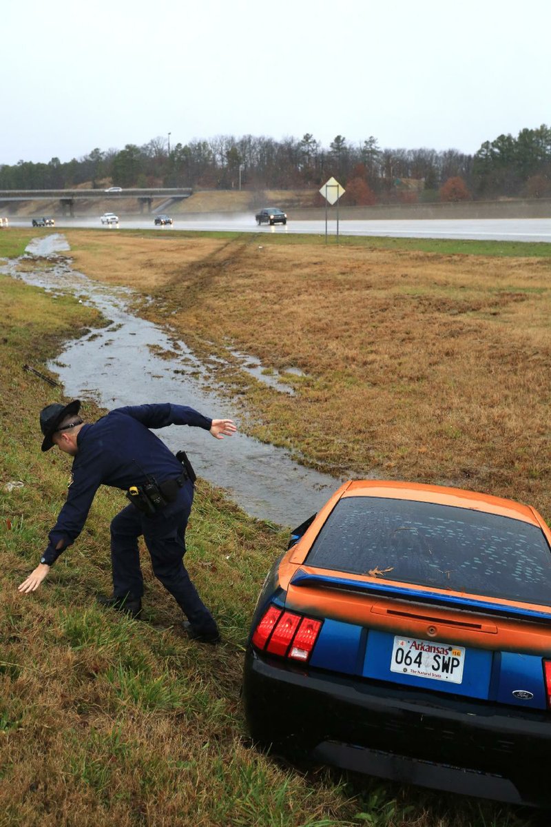
At 7 p.m., the crashes had stalled traffic for 10-12 miles in eastbound and westbound lanes, state police spokesman Bill Sadler said. It was unclear whether there were any injuries. Sadler said the cause of the crashes was unclear, but they could have been caused by straight-line winds.
Also Saturday, David Cox, a meteorologist with the National Weather Service who is based in Jackson, Miss., told The Associated Press that an apparent tornado struck near Dermott in Chicot County.Two people were injured and about 20 homes were damaged, he said.
On Friday evening, high winds damaged roofs and toppled trees and power lines in Redfield in northwest Jefferson County. National Weather Service warning coordinator John Robinson of North Little Rock said he expects to inspect the areatoday to see whether the damage was from a tornado.
Winds also knocked out power to thousands of Entergy Arkansas Inc. customers across the state. By 11 p.m. Saturday, fewer than 4,000 customers were without power, according to a map on the utility’s website. Customers can refer to both residences and businesses.
Other utilities around the state reported only a handful of power failures.
The storms formed after a cold front sagged into Arkansas from the northwest Friday and met warm, moist air. It stalled over the state, causing prolonged, heavy rainfall in some areas, which had law-enforcement officers across the state alert for flooding.
The most swollen river in the state by 5 p.m. Saturday was the Eleven Point River in Ravenden Springs, the National Weather Service reported. The river had reached 15.97 feet, its moderate flood stage, and was expected to rise another 4 feet in the next 24 hours, taking it within inches of its major flood stage.
“We have 123 low-water bridges in the county,” Randolph County Judge David Jansen said. “And every one has water over them.”
Jansen said melting snow from two weeks ago saturated the ground, so water can’t run off as easily. More than 6 inches of snow fell in Pocahontas on Dec. 5.
“There’s nowhere for water to go,” he said. “Our ditches are full. We’re going to have to wait until the water goes down to see how much damage there is.”
The sheriff’s office reported late Saturday that no roads inthe county had been closed, although one person suffered minor injuries after driving a vehicle through standing water on Arkansas 90.
Minor flooding was reported at seven other rivers, most in northeast Arkansas. The rivers were expected to crest in the next 24 hours and remain in their minor flood stages. The Cache River in Patterson was the closest to a higher flood stage, as its waters had risen to 10.79 feet, and was expected to crest within inches of its moderate flood stage, 11 feet.
The Arkansas Highway and Transportation Department tweeted Saturday evening that parts of Arkansas 18, 224 and 384 in Jackson County were closed because of high water, as were parts of Arkansas 91 and 226 in Craighead County and Arkansas 364 in Cross County near Wynne. A portion of U.S. 67 in White County was closed because of potholes, the department saidon Twitter, and traffic was being diverted.
In Little Rock, police said there were several reports of standing water on roadways. At 5 p.m., East Sixth Street at Pepper Avenue had been closed because of flooding, and low-water bridges at Kanis Park at 820 S. Rodney Parham Road and War Memorial Park at 5101 W. Markham St. had been closed. Police reported a downed tree at West 18th and South Arch streets. By late Saturday, there were no reports of serious crashes or injuries related to the weather.
North Little Rock police spokesman Sgt. Brian Dedrick reported that Baucam Pike at Campbell Road was closed because of flooding Saturday, but a vehicle became stranded in the water after apparently driving around police barricades. Crystal Hill Road near White Oak Drive also was closed temporarily. There were no reports late Saturday of serious injuries or damage because of weather, Dedrick said.
Freezing rain fell in Northwest Arkansas early Saturday before turning to rain. Bella Vista reported one-tenth of an inch of glazed ice on trees and power lines, said National Weather Service meteorologist Joe Sellers of Tulsa. Fayetteville’s temperature dropped from 63 degrees Friday to 33 degrees early Saturday. By afternoon, the temperature climbed back to 41 degrees, but forecasters said it will drop again, and snow and sleet could fall early this morning.
Farther west, freezing rain pelted eastern and central Oklahoma, coating trees and power lines with up to a half an inch of ice by Saturday afternoon, Sellers said.
In southeast Arkansas, the area saw several varieties of weather at the same time. At one point Saturday, the National Weather Service in North Little Rock issued a wind advisory, warnings for flash flooding and thunderstorms, and a tornado watch for the southeast corner of the state.
“We’re getting heavy rain,” Arkansas County Sheriff Allen Cheek said. “We hear the occasional rumble of thunder.”
He said a friend of his measured 6 inches of rainfall in a gauge early Saturday. The friend poured it out and measured another 3.5 inches by early afternoon.
“That’s nine-and-a-half inches,” Cheek said. “The water’s getting deep. Our secondary ditches are full, and water’s starting to come up on the roads.”
In Yell County, some county roads near Havana in the northwestern corner of the county were covered in water, a sheriff’s office dispatcher said.
Arkansas, Pages 15 on 12/22/2013