
Officials say one person was killed in Springdale on Monday night when a storm packing winds of nearly 70 mph threw a street sign into the victim's vehicle.
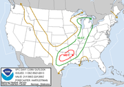
More chances for severe weather in Arkansas are possible Tuesday as a "potent" system capable of producing tornadoes, damaging winds and large hail moves in, the National Weather Service said.
Arkansas State Police say the deadly accident happened about 7:30 p.m. Monday as 19-year-old Austin Wayne Deere of Prairie Grove was driving a Honda Accord west on U.S. 412 near Robinson Road.
According to a preliminary report, high winds blew down a street sign and then sent it into Deere's car. He was pronounced dead at the scene.
The fatality is included in National Weather Service reports about the ongoing storm system. Winds in Springdale were measured at 69 mph about the same time the accident occurred.
The weather service says showers and thunderstorms are expected to redevelop later Tuesday morning and into the afternoon as a "potent storm system" moves in.
"Any thunderstorms that do develop will have the potential to become severe with high levels of instability and moisture in place," the agency said in a statement. "The main threats with the strongest storms will be damaging winds and destructive large hail."
Officials say there is also a risk for tornadoes, particularly in southwest Arkansas, because of the "combination of instability and low level shear."
Flash flooding is also a concern, with some places likely to see several inches of rainfall in a short time. Flash flood watches are in effect for much of the central and northern parts of Arkansas.
Elsewhere in Arkansas overnight, a camper and mobile home were blown over southeast of Steprock in White County, trees and power failures were reported near Blue Eye in Carroll County and power poles were down near Heber Springs. Trees were reported down near Sims in Montgomery County, London in Pope County, Vilonia in Faulkner County and at the airport in Little Rock.
Entergy on Tuesday morning reported more than 5,300 customers without electricity, including nearly 1,200 in Pope County, about 1,500 in White County and more than 700 each in Faulkner and Cleburne counties.
North Little Rock Electric said scattered power failures remained in the city after several thousand near downtown and in Levy lost electricity overnight. Power was restored early Tuesday for most of those customers.
Southwestern Electric Power Co. said about 500 combined customers were out in Benton and Carroll counties. Carroll Electrice Cooperative reported 1,807 customers without power, mostly in Benton and Carroll counties.
