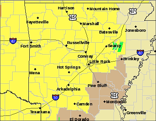
5 p.m.: Tornado watch extended for some Arkansas counties
The tornado watch issued Thursday morning for the majority of western and central Arkansas has been replaced with another watch that runs until midnight. Counties in the southwest corner of the state are under a tornado watch until 9 p.m., according to the National Weather Service.
A line of strong storms — which may produce gusty winds, large hail and isolated tornadoes — is expected to enter the state from the west in the early evening hours and should reach eastern Arkansas overnight, the weather service reports.
10:11 a.m.: 'At least a few tornadoes' expected by time storms move out; more watches likely
An official with the National Weather Service says Arkansas is expected to see additional tornado watches beyond the one already issued this morning.
John Robinson, warning coordination meteorologist with the weather service in North Little Rock, said the existing watch, which runs through 5 p.m., may not be the last. It covers more than 40 counties including most of northern, western and central Arkansas.
"It's very unlikely that this will be the only tornado watch for Arkansas today," he said in an email. "Storms have already entered western Arkansas. General movement will be to the east and northeast."
The earlier round of severe storms will be followed by another round in the afternoon or early evening, Robinson said, with the threat of storms moving out of the state overnight.
"I expect that we will see some reports of very large hail (golf ball size or larger), damaging winds, and at least a few tornadoes today and this evening," he said. "At least one or two tornadoes reaching EF2 or greater intensity could occur."
10 a.m.: Tornado watch issued; 'Dangerous storm' tracks through Scott County
A tornado watch has been issued ahead of severe storms expected to develop in Arkansas, particularly in the afternoon and evening, the National Weather Service warned Thursday.
The tornado watch runs through 5 p.m. for a large swath of the state.
Western Scott County was under a tornado warning after radar at 9:32 a.m. indicated a "dangerous storm" capable of producing a tornado 3 miles west of Morgan Springs, the weather service said. That warning was expired just before 10 a.m. Phone lines were reported down in Cauthron after the storm moved through, but there were no other immediate reports of damage.
The weather service said isolated storms would be possible through the first half of the day, but the threat for them to reach severe levels was low.
In the afternoon, a stronger system will move through the region and bring a cold front into Arkansas, the weather service said. Storms will then develop ahead of that front.
"Storms that become severe will be capable of producing large hail, damaging winds and tornadoes," the weather service said.
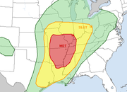
The Storm Prediction Center has most of Arkansas under a moderate risk for severe weather Thursday through Friday morning. The tornado threat is pegged at 10 percent to 15 percent for most of the state, while the chance of damaging hail is listed at 45 percent for much of Arkansas.
Up to an inch-and-a-half of rain is possible with the storms. Winds, meanwhile, may gust above 30 mph at times.
IN TODAY'S EDITIONS
- http://www.arkansas…">Weather prime for storming; forecasters say twisters possible
Districts cancel after-school activities
The Little Rock and Pulaski County Special school districts Thursday canceled their after-school sports and activities because of the threat of severe weather.
All bus routes for athletic practices were also canceled, the Little Rock district announced on its website.