UPDATE:
A winter storm moving into Arkansas may bring with it 4 inches of snow or possibly even more, the National Weather Service said Sunday.
John Robinson, warning coordination meteorologist with the National Weather Service in North Little Rock, said in an email some precipitation will begin late Sunday or early Monday, but the bulk of the event will take place Monday night into Tuesday morning.
"Indeed, if everything plays out as it looks now, there will likely be hazardous driving conditions over a large part of the state before this weather system gets through with us," he wrote.
Robinson said it's still unclear where the heaviest band of snow will fall, so it's too early to upgrade winter storm watches in effect for a large swath of the state to winter storm warnings.
"... [T]his heaviest band could very well be only two or three counties wide," Robinson wrote. "This is a good indication that there will be a sharp cut-off between areas that get quite a bit of snow and other places that get much less. It still looks as though 2 to 4 inches of snow will occur in the heaviest band, but it is not out of the question that there could be a narrow stripe of larger amounts."
Northern Arkansas will see mostly snow in this system while central Arkansas will likely get a mix of snow, sleet and freezing rain before transitioning to all snow Monday night, Robinson said. Southern Arkansas, meanwhile, is expected to see rain during the day Monday and a wintry mix that night into Tuesday.
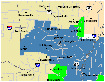
Bradley, Cleburne, Independence, Jackson, Newton, Searcy, Stone and Van Buren counties had been set to go under a winter storm watch Monday, but they were removed from the list Sunday afternoon.
Robinson said that means those areas aren't expected to require a winter storm warning, but they may still get wintry weather.
EARLIER:
Road conditions across Arkansas were much improved Sunday from a day earlier, when parts of the state were dealing with up to 3 inches of snow on the ground.
The Arkansas State Highway and Transportation Department reported clear conditions on most of the state's major highways. The only exception at 9:30 a.m. was Arkansas 10 west of Little Rock, which was said to be 95 percent clear but not free of ice patches.
Some slush and isolated slick spots remained on roadways in Little Rock's Stifft Station, Hillcrest and downtown neighborhoods Sunday morning, but traffic was moving through them without difficulty.
Any remaining slick areas are expected to melt Sunday when temperatures across the state surpass the freezing mark, hitting the 40s in central Arkansas and even the 50s in Camden and Monticello.
But the warm-up — and perhaps the clear roads — may be short-lived, the National Weather Service warned. Another system is moving into the region Monday, bringing with it the possibility of snow.
A winter weather watch set to go into effect at noon Monday was extended Sunday morning. It now includes more than 30 counties, including Pulaski, in a large swath of the state.
John Robinson, warning coordination meteorologist with the weather service in North Little Rock, said in an email that the counties under the watch can expect to see 2 to 4 inches of snow.
Light snow in the north and a light mixture of freezing rain, sleet and snow in central Arkansas will begin after midnight with minimal accumulation. The precipitation will increase as the day goes on before ending by around midnight Monday, Robinson wrote.