An agreement has been reached on a 14.7-mile extension of a trail that is being developed on an abandoned railway line in east Arkansas.
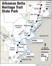
Much of the extension of the Delta Heritage Trail State Park from Rohwer to Arkansas City will run atop a Mississippi River levee that Richard Davies, the director of the Arkansas Parks and Tourism Department, said will afford trail users "a sweeping view of the Mississippi River flood plain, including numerous watchable wildlife opportunities, and views of the Arkansas Delta agricultural landscape."
Development of the state park has been a collaborative effort between Davies' agency and the Arkansas Highway and Transportation Department since 1992 when the Union Pacific Corp. donated the land on which the abandoned railroad line sits -- extending from a mile south of Lexa to Cypress Bend, which is about 5 miles north of McGehee. The line, before the extension was added, stretched more than 73 miles.
The park is being developed under the national "rails to trails" initiative in which abandoned railroad lines are converted to pedestrian and bicycle trails to foster healthy communities across the United States. More than 20,000 miles of rail-to-trail conversions have been completed, with 9,000 additional miles waiting to be completed, according to the Highway Department.
The extension required additional partners, including the Southeast Arkansas Levee Board, the U.S. Army Corps of Engineers and Desha County, said Robert Moore Jr. of Arkansas City, a member of the Arkansas Highway Commission.
"This is really going to be a great recreational attraction for southeast Arkansas," he said.
To date, about 20 miles of the trail has been completed, all of it a crushed-rock path on the north end of the route extending from Helena Junction, about a mile south of Lexa, to Elaine, all in Phillips County.
Work will now begin on the new extension to the south with construction of an "asphalt surface shared-use roadway atop the Mississippi River mainline levee" under two separate contracts, each covering about 7 miles, said Jeff King, chief park planner for the Parks and Tourism Department.
The first contract is expected to be awarded in August and the second early next year, department officials said. Together, they are estimated to cost about $5.6 million.
That cost will be covered by the sale of the 33 miles of tracks taken from Snow Lake to Cypress Bend. The state acquired the tracks for $700,000 and sold them for $5.7 million. The railroad took the remaining tracks.
"We actually made a good investment," said Greg Butts, the Arkansas State Parks director.
Once the section is completed next year, it will be designated Arkansas 600. Its maintenance, like all state park roads, will become the responsibility of the Highway Department. The Arkansas Highway Commission approved an order setting out that responsibility earlier this month.
The project on the south end also will include a trailhead that "will highlight area recreational and historical points of interest as well as restroom facilities for visitors and campers," Moore said.
Construction of the south extension to Arkansas City will provide a "link to a community with historical significance and heritage tourism opportunities," Davies said.
Development of the full trail is years and millions of dollars away, parks and tourism officials said. They expect it to be financed by a combination of proceeds from the one-eighth percent sales tax dedicated to conservation projects, grants and state highway money.
The most expensive parts of the trail will be converting the bridges over the Arkansas and White rivers to use for pedestrians and bicyclists. The Parks and Tourism Department estimates the cost of those projects at a collective $20 million, or a similar price tag for converting the Arkansas River crossing at the Clinton presidential library in Little Rock, Davies said.
Metro on 06/30/2014