Flooding from record-breaking rainfall damaged several rural roads and led one rural water supplier to issue a "boil water" notice, but otherwise much of Northwest Arkansas' infrastructure weathered the weekend's high water fairly well, officials said Tuesday.
RELATED ARTICLES
http://www.arkansas…">River gorged, floodwaters to stay awhilehttp://www.arkansas…">Winter hits New England at last http://www.arkansas…">Flooding recedes from War Eagle Mill http://www.arkansas…">Beaver Lake full; 7 gates open
Rivers began rising after more than 7 inches of rain fell on some areas in Northwest Arkansas during a 24-hour period ending Monday morning, and runoff from the deluge poured into the Arkansas River basin.
Reporting damage
Benton and Washington county emergency management officials asked residents to report property damage in order to have a total amount for any state or federal aid that becomes available. Northwest Arkansas governments and private property owners can be eligible for the assistance. To reach them, call:
• Benton County Emergency Management Agency: (479) 271-1004
• Washington County Department of Emergency Management: (479) 444-1722
Source: Staff report
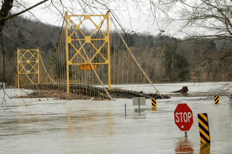
Crews were out in force from Bella Vista to Devil's Den State Park taking stock of damage and making the first repairs to county and city roads as runoff from the weekend's heavy rain continued subsiding. Only a dozen or so scattered roads remained under water or otherwise impassable by Tuesday afternoon, officials said.
"Everything's real soggy, obviously, and there was some, I would say, minor flooding," said Tim Scott, assistant superintendent at the state park in southern Washington County, where floodwater Sunday gushed over the Lee Creek dam. Tree limbs left on the dam will have to be cleaned up, he said, but the trails and roads criss-crossing the hilly park are largely intact. "I think we lucked out."
Around the state, the Arkansas River is expected to crest higher and flooding will last longer than anticipated because the river's tributaries are slow to move the water from the weekend's heavy rainfall.
A combination of flooding on the Mississippi River and releases from Oklahoma reservoirs could keep the glut of water in Arkansas for several days, said National Weather Service hydrologist Tabitha Clarke of North Little Rock.
The most serious damage in Northwest Arkansas appeared to be to a water main in western Washington County that supplies Washington Water Authority, which provides water to rural customers around the county. Many of the authority's customers remained under a precautionary alert Tuesday night from the Arkansas Department of Health to boil water for at least a minute before use.
The leak was repaired Monday, according to the authority, and officials Tuesday were in the process of testing the water to make sure it was safe again.
The notice didn't include the number of customers affected or the cause of the break, and director Josh Moore didn't return two phone messages Tuesday requesting more detail. The notice stated customers with account numbers starting with 02, 03, 12 or 20 weren't affected.
"It's pretty easy to imagine that with the type of rain that your area received, it could wash out water mains if they were in an area where the soil was vulnerable," said Jeff Stone, director of the Health Department's engineering section, adding he didn't know the situation's specific details. "A lot depends on the circumstances, but usually they can fix these mains fairly promptly."
Morrilton and Pendleton are predicted to see the third-highest Arkansas River stages recorded at their gauges, and Pine Bluff's river crest, expected Saturday, will be half a foot higher than June flooding, hydrologists with the National Weather Service said.
Clarke said Arkansas City in Desha County, near where the Arkansas River pours into the Mississippi River, will remain categorized as being in "major flood" through Jan. 13. The gauge there gives hydrologists an indication of how fast Arkansas River floodwater will move out of the state.
"It's less than 2011," Clarke said, referring to when the Mississippi River was so flooded it backed up water in the White and Arkansas rivers. "It's not that crazy, but it will be worse than in 2008. This will be a big flood."
As for Northwest Arkansas roads, many workers focused first on emergency repair to open all but 11 Benton County roads and a handful of Washington County roads, county officials said. Tontitown's Javello Road and Johnson's Ball Street remained closed Tuesday due to water and damage, according to Washington County Sheriff's Office social media posts.
Permanent repair will begin once the full extent of the damage is visible, said Jeff Clark, Benton County's public services administrator.
"I would not begin to want to put a number on it," Clark said of the amount of damage. "Our teams are still in the field gathering information."
The water washed away segments of the dirt Opal and Orchid roads in southwest Bentonville, and crews were busy clearing debris from both, said Tony Davis, the city's street manager. Opal was repaired enough by the afternoon for emergency personnel to pass through but was still closed to the public; the city won't move on to Orchid before Opal's ready to go, Davis said.
Rogers, Springdale and Fayetteville had fairly minor damage, if any, officials said. Some pumping stations and manholes in the sewer systems and manholes overflowed here and there, and some park trails were washed out. Otherwise city workers were mainly clearing out mud and tree debris that's fairly routine for creekside trails.
"It's just more inconvenience than anything," said Terry Gulley, Fayetteville's transportation services director. "Luckily it (the rain) wasn't an inch an hour."
Continual rain from Saturday through Monday dropped 8 inches in Fayetteville and 10 inches in Bentonville, according to the National Weather Service.
Gov. Asa Hutchinson declared 21 Arkansas counties disaster areas, including Benton and Washington. Both county judges declared emergencies as well. The declarations help free up federal assistance if it's needed.
One person died Monday near Dover in northern Pope County, authorities said. The Pope County Sheriff's Office identified the victim Tuesday as James Evan LaRue, 31, of Dover. Deputies found LaRue in a creek along Wallace Ridge Road. Deputies said it appeared LaRue tried to drive across a low-water bridge and his vehicle became stuck on a downed tree lodged in the road.
In Little Rock, where flood stage is 23 feet, the Arkansas River will reach 26 feet on Friday, more than 3 feet higher than the river crested at 22.89 feet during flooding in June. On Tuesday, the river measured 20.26 feet and portions of Burns Park in North Little Rock were already flooding, said North Little Rock spokesman Nathan Hamilton.
Kathleen Deluca, owner of Lewisburg Bay RV and Mobile Home Park in Morrilton, moved at least five campers from low-lying areas to ensure they would not be flooded.
"You can see the road going right into the river," she said of the rising water. "All we can do is wait for it to come through and take pictures."
Deluca bought the RV park a year ago and has endured three of the area's top 10 flood events, she said.
"This is definitely worse than the spring," she said.
The Arkansas River is expected to crest in Morrilton at 41 feet Thursday -- the third-highest mark reached there. The record of 42 feet was set April 19, 1927. Flood stage there is 30 feet. In June, the river rose to 38.64 feet.
Conway also will see flooding, where the river will reach 281 feet, said Faulkner County spokesman David Hogue.
Downstream at Pine Bluff, emergency shelters opened for those displaced by the rising water.
The river is expected to crest at 46.5 feet Saturday, about half a foot higher than its crest of 45.95 in June.
"This is going to be worse than the spring," said Wesley Hunt, an employee with the Jefferson County Office of Emergency Management.
Homes in the Harbor Island subdivision along the Arkansas River were evacuated in anticipation of flooding.
"Water is on the rise," said Karen Blevins, Jefferson County Office of Emergency Management coordinator. "The water is going over roads and they can't get out soon."
The Corps of Engineers kept four locks and dams closed Tuesday because of the rapid river, said spokesman Jay Townsend. Locks and dams remained closed to traffic at the Toad Suck Lock and Dam near Conway, along with those in Fort Smith, Ozark and Morrilton.
"We thought this was going to be a short-term event," Townsend said. "It's going to stay high for at least a day or two longer than expected."
He said the corps' releases of swollen Oklahoma reservoirs into the Arkansas River won't cause flooding to increase, but the combination of the slow flow of the river into the backed up Mississippi River and the additional water coming from downstream will keep levels above flood stage.
"As the crest passes, the tributaries still have to get rid of water," Townsend said.
NW News on 12/30/2015