5 P.M. UPDATE:
Gov. Asa Hutchinson named six more counties as disaster areas Thursday, bringing the statewide total to 38.
The counties added Thursday were: Boone, Izard, Lawrence, Monroe, Pike and Stone.
Read Friday's Arkansas Democrat-Gazette for full details.
2 P.M. UPDATE:
Arkansas Gov. Asa Hutchinson says multiple state agencies are involved in the response to flooding that's affecting parts of the state.
So far, Hutchinson has issued disaster declarations for 32 of the state's 75 counties after the severe storms and flooding. Hutchinson said in a statement Thursday that the Arkansas Department of Emergency Management is monitoring the flooding around-the-clock and holding daily conference calls with local leaders.
National Guard units have been staged to help place sand bags in some areas and help with high water transportation. Arkansas State Police troopers are providing additional patrols in evacuated areas, while state inmates are helping place sand bags as well.
The Arkansas Game and Fish Commission is helping with swift water rescues and the state's forestry department is helping with debris cleanup.
- The Associated Press
EARLIER:
At the close of 2015, the effects of heavy rain in Arkansas that began last week and continued through the Christmas weekend are set to continue through at least Sunday.
That storm, which saturated portions of the state and spawned two EF1 tornadoes in south Arkansas, is behind runoff still flowing as of Thursday morning into waterways throughout the state, causing them to swell.
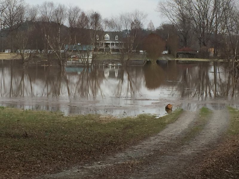
In certain areas, such as Toad Suck and Little Rock, the water is damaging homes, businesses and farmland.
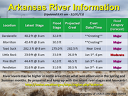
The National Weather Service on Thursday morning said the Arkansas River at Toad Suck is near its crest. Two other areas along the river at Dardanelle and Morrilton were in the process of cresting as of 9 a.m., the weather service said.
Across Arkansas, flood warnings remain in effect for waterways that have received excess runoff from holiday weekend rainfall.
"Moderate to major flooding [is] expected to persist for a while," the weather service said in a post to Facebook. "If you have property or other interest[s] along the river, continue to monitor as this flood event persists through the coming days."
LITTLE ROCK:
The Pulaski County sheriff's office said residents Thursday morning were pulled from a Little Rock home near Two Rivers Park on County Farm Road in an area southeast of Pinnacle Mountain State Park. The number of residents rescued was not immediately available.
A portion of Rebsamen Park Road from the roundabout at Riverfront Drive to Overlook Drive will be closed starting at 2 p.m. Thursday, the city of Little Rock said.
The city on Wednesday announced the temporary closure of a number of parks due to the ongoing flooding, including Boyle, Hindman, Kanis, Murray parks; and Rebsamen Park Golf Course.
Officials also advised that the residential area near Fourche Dam is of "particular concern" ahead of cresting in Little Rock.
By about 6 p.m. New Year's Day, the Arkansas River at Little Rock is forecast to crest at 26 feet, 3 feet above flood stage and in the top 10 for historic crests.
TOAD SUCK:
Julia Burgess, a homeowner in the Toad Suck community along the border of Faulkner and Perry counties, told the Arkansas Democrat-Gazette that she "barely" got out of home about 9 a.m. Wednesday before floodwaters rose in the area.
Burgess told the Democrat-Gazette that she was only able to leave with "just a suitcase full of clothes."
The river level in the area near Bigelow is set to reach 282.8 feet into New Year's Day at the time of cresting, according to the weather service. That level would make the river 1 inch below the record set May 7, 1990.
Officials in the area are advising residents to heed warnings about potential flooding and monitor water levels at their homes in the event that evacuating becomes necessary.
PINE BLUFF:
On Sunday, the Arkansas River at Pine Bluff is forecast to reach 46.5 feet, about 4.5 feet above flood stage. As of 11 a.m. Thursday, the river level was at 44.5 feet in the area. Into New Year's Day, the river is set to reach major flood stage, according to the weather service.
In a news release, the Jefferson County sheriff's office said shelters have been opened and deputies have begun preparations in advance of expected flooding.
Officials advised residents in the flood-prone areas of Swan Lake, Wright-Pastoria and Island Harbor to be prepared for evacuation.
ARKANSAS RIVER CRESTS
• Dardanelle — cresting as of Thursday morning in major flood stage; latest observed level was 40.16 at 9 a.m. Thursday, a decrease from highest observation of 40.83 feet recorded Monday night
• Morrilton — Cresting underway through Thursday evening at 40.6 feet in major flood stage; latest observed level was 40.41 feet at 9:15 a.m. Thursday
• Toad Suck — late Thursday into early Friday at 282.8 feet in major flood stage; latest observed level was 282.4 feet at 9 a.m. Thursday
• Little Rock — Friday evening at 26 feet in moderate flood stage; latest observed level was 23.87 feet at 8 a.m. Thursday
• Pine Bluff — Sunday morning at 46.5 feet in major flood stage; latest observed level was 44.43 feet at 9 a.m. Thursday
Source: National Weather Service in Little Rock