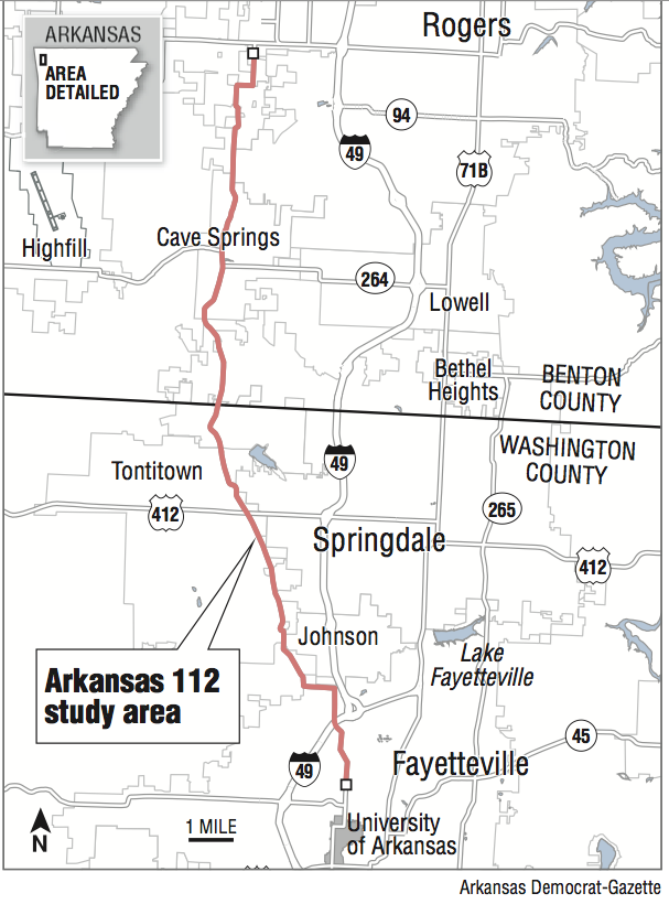
An Arkansas Highway and Transportation Department study of a segment of Arkansas 112 in Northwest Arkansas concluded it can be improved to handle future traffic volume better and preserve its role as an important north-south corridor.
The study found that with improvements, the 20-mile north-south route between Fayetteville and Bentonville could serve as an alternative to building a western beltway, which regional planning officials have discussed in the past.
"Highway 112 serves as the only major north-south route west of Interstate 49, making it crucial for regional mobility," according to the study. "Based on the traffic and safety analyses, improvements to Highway 112 are needed to better accommodate anticipated traffic growth and improve safety."
The state Highway Commission formally adopted the study at a meeting Wednesday in Little Rock. Adoption of the study allows the department to use it as a planning guide for future work on the highway.
The highway now has two 10-foot lanes and no shoulders, which was fine when the area was largely rural with little traffic. But like elsewhere in the region, development has grown up along the route.
"Development in the area is causing congestion at various locations that will continue to increase in future years," the study states.
The southern part of the route now has as many as 14,000 vehicles per day. And as many as 22,000 vehicles daily travel the highway at the I-49 interchange. The study attributes much of the peak traffic to the University of Arkansas.
Traffic on some parts of the highway could more than double by 2035, according to a traffic demand model and analysis that incorporates potential demographic land-use changes into the traffic forecasting.
As congested as the route is now, it operates at an acceptable level of service, which is a grade traffic planners and highway engineers use to measure traffic flow using speed, travel time, delay, freedom to maneuver, traffic interruptions and comfort.
There are six grades of traffic flow, with an A level of service representing the best and F the poorest. The route now has a D level of service, which the study said is acceptable for an urban two-lane highway. But the level of service will fall by 2035, according to the study.
"Widening Highway 112 to four travel lanes would improve the traffic operations to an acceptable [level of service] for current and future traffic volumes," the study concluded.
A crash analysis of the study area using data from 2010, 2011 and 2012 tallied 274 crashes, none of them fatal and seven of them resulting in serious injury. Of the total crashes, 105 were rear-end mishaps.
The study divided the route into 12 segments and found the crash rates were close to the statewide average for similar highways. But it found the crash rate notably higher than the statewide average for the southern-most segment, which runs from Janice Avenue to Truckers Drive in Fayetteville. More than half of the crashes in the corridor, or 146, occurred in that segment, according to the study.
The Highway Commission chairman, Dick Trammel of Rogers, said Wednesday that he believes the study shows that widening and making other improvements to Arkansas 112 would be a more cost-effective alternative to building a western bypass, as has been discussed in the region.
"In the past, I've heard talk about going out building a big western corridor," Trammel said."What I like about [Arkansas 112] is it's there, we won't have to go buy all new right of way and it's the least expensive and quickest way we can have another corridor on the west side. This study shows that."
Scott Bennett, the department's director, agreed.
"It appeared to us to be more feasible -- and likely much less costly -- to explore the option of improving the existing corridor -- with the possible exception of having to look at a bypass or two -- than moving even farther west and building something new," he said.
"That's why we initiated the study, which found that we can improve the existing corridor and serve traffic well into the future. Also, improvements to the existing route could be phased in and usable without having the entire corridor improved, unlike building a new location corridor. This makes sense since we know improvements will have to be completed in phases."
Still, the planning estimates included in the study found that widening the route would be costly, ranging from $108.8 million to $134 million, depending on which alternatives on some parts of the route are constructed.
The total costs includes construction, acquiring rights of way, utility relocation and preliminary and construction engineering. The costs likely would be higher because the study used 2015 dollars.
The route does have some environmental constraints, including historical structures, cemeteries, springs, and habitats for several federally listed endangered species, according to the study. The study area also crosses nine regulated flood plains. Repercussions for these features should be minimized, the study said.
The corridor also is near the environmentally sensitive Cave Springs Recharge Area. A U.S. Fish and Wildlife study is underway to determine what steps need to be taken to protect threatened and endangered species in the area. Any further studies or potential projects in the corridor should consider recommendations from the agency's study once it is complete, the corridor study said.
Metro on 07/23/2015