A tropical storm that hit the Texas Gulf Coast on Tuesday morning was tracking farther west than expected as it made its way inland, but it will still dump plenty of rain into the basins of the Arkansas and Red rivers, which are just now recovering from last month's flooding.
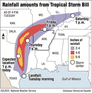


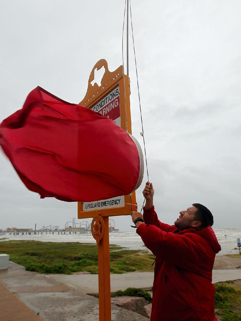
Tropical Storm Bill made landfall shortly before noon Tuesday at Matagorda Island northeast of Corpus Christi. The National Hurricane Center in Miami reported that the storm had maximum sustained winds of 60 mph and was expected to dump up to 11 inches of rain on areas near Dallas.
Flood preparation
Before:
• Make emergency kit for essentials and form a family emergency plan.
• Seal basement walls and form barriers around the building.
During:
• Be aware of nearby streams and listen to TV or radio for flood warnings.
• If flooding is imminent, unplug appliances and move furniture to higher level.
• Avoid moving floodwater.
After:
• Avoid moving and stationary floodwater and keep on solid ground.
• Clean and dry everything that got wet.
• Be aware flooded buildings can be dangerously damaged, even if damage isn’t visible.
Source: Federal Emergency Management Agency
Galveston County officials in Texas evacuated the low-lying Bolivar Peninsula, and school districts from Galveston to Houston canceled classes Tuesday.
Federal Emergency Management Agency personnel sent to Texas and Oklahoma after severe flooding over Memorial Day weekend that killed more than 30 people will remain in the region to assist in the aftermath of Tropical Storm Bill, White House spokesman Josh Earnest said Tuesday, according to The Associated Press.
The storm's path will take it through eastern Texas and south-central Oklahoma before making an eastern turn into Arkansas early Friday morning.
Northwest Arkansas could see 4 to 6 inches of rain in a line west from Mena to Clarksville, meteorologists at the National Weather Service in North Little Rock said.
Since the storm system is similar to a small hurricane, forecasters warned that up to 8 inches of rain could fall on localized areas where heavier rain bands move through.
"There will be several waves of moisture with this," National Weather Service hydrologist Tabitha Clarke of North Little Rock said of the western half of the state. "We'll see several rounds of rain."
But a ridge of high pressure in the southeastern United States could push the storm system farther west, in which case eastern Arkansas would likely see less than an inch of rain over the next few days.
The storm track's shift toward the west would be good news for those along the Arkansas and Red rivers.
Clarke said she expects the rainfall will still produce flooding, but it could be "minor compared to major."
In early May, heavy rains fell on Fort Smith and the Arkansas River Valley, pushing the Arkansas River above flood stage. Up to 15 inches of rain also fell in eastern Oklahoma and Texas, sending torrents of water into the basins of the Arkansas and Red rivers.
The Arkansas River reached 46 feet in Pine Bluff two weeks ago, 4 feet above the flood stage and the fifth highest level the river has risen in the Jefferson County town.
On Tuesday, the river measured at 12.8 feet in Little Rock, down from the 23-foot mark it reached June 3.
Still, the river is flowing at 150,000 cubic feet per second -- three times the normal rate -- and the U.S. Army Corps of Engineers has continued to issue a small-craft advisory for the entire river because of the rapid currents.
The Arkansas River will see a rise of a foot or so over the next few days as Corps officials release water from Oklahoma reservoirs into the Arkansas River system.
The releases are normal procedures and not because of the forecast for heavy rains, said Laurie Driver, a spokesman for the Corps in Little Rock.
"We are operating as we would normally," she said. "We cannot react on forecasts. How much water will fall? Where will it fall? Which watersheds will it fall into? We take those into consideration and create several plans in case, but we don't react until the water hits the ground."
She said in the spring of 2011, initial forecasts showed heavy rain was headed for Beaver Lake. Some criticized the Corps for not releasing water from the lake into Table Rock Lake in anticipation of the storm. But the storm's track then shifted slightly to the east, pouring the heaviest amount of rainfall into Table Rock Lake, she said.
Greg Estep, chief hydrologist at the Corps' Tulsa Division, said most of the division's reservoirs that drain into the Arkansas River are at about 50 percent to 55 percent full now.
"We cleared a bit over the last week for more storage," Estep said. "But depending upon the storm's track, the intensity of rainfall and if we have short storms or stalled out ones, we could have the potential for significant flooding.
"If we get 10 inches of rain, like some projections are showing, we are going to have some problems."
In southwest Arkansas, Millwood Lake released water at a rate of 38,000 cubic feet per second Tuesday after reaching a record high level Sunday.
The reservoir crested at 282.9 feet Sunday, topping its previous record of 282.0 feet set on May 22, 1968.
"We're starting to get rid of water, but there's more rain headed our way," said Steve Spicer, lake operations manager. "There's an amazing amount of water now. But Millwood is doing what it's supposed to do."
Kim Murphy, the office manager at Millwood State Park, said she can look out her office window and see the lake. Before the flooding, she would have to drive down a road toward the beach houses to see the water.
"We're 23 feet above normal," Murphy said. "The water is to the roofs of the beach houses, and our marina dock has buckled. There will be a lot of cleanup and repairs when the water goes down."
The park has been closed because of flooding since May 12 and will probably remain closed for several months, she said.
Millwood releases water into the Little River, which empties into the Red River at Fulton.
The river crested at Fulton on June 6 at 32.1 feet, more than 5 feet above its 27-foot flood stage.
The river slowly began dropping, and on Tuesday, it measured at 20.2 feet.
"A lot of the rain could possibly end up in the Red River," said National Weather Service meteorologist Matthew Duplantis of Shreveport. "We could see 8 to 9 inches of rain east of Dallas. That's going to end up in the Red River."
Lafayette County Office of Emergency Management coordinator Danny Ormand said the Red River had fallen "a lot."
"That gives a lot more room for the extra water," he said.
Ormand and Corps officials monitored the 40 miles of levees in Lafayette County in May, finding more than 30 leaks. Workers shored them up with gravel and sand, and no levees failed, he said.
"If we get 7 to 10 inches of rain, it'll cause us some additional concern," he said. "We'll take this on a day-to-day basis and see what the river does."
The northwestern quarter of the state is under a flash flood watch, and the Weather Service issued a flood warning for the Arkansas River at Van Buren, where the river climbed to 22.49 feet Tuesday afternoon. Flood stage there is 22 feet.
"We have several days ahead of us to see where all the rain goes," Clarke said. "We will at least see some minor flooding from this."
Information for this article was contributed by The Associated Press.
A Section on 06/17/2015