CROWLEY'S RIDGE STATE PARK -- Most of the Arkansas Delta ranks among the lesser scenic regions of the Natural State.
But the monotony of the flat landscapes inland from the Mississippi River is broken by the distinctive geological intrusion of Crowley's Ridge.
Varying from 1 to 12 miles wide, the ridge rises 250 feet above the flood plain. Along its crest runs a National Scenic Byway, so designated in 1998. Crowley's Ridge Parkway extends 218 miles north from Helena-West Helena, with the last 10 miles going into Missouri. It shifts among more than a dozen federal, state and county roads on its way through eight Arkansas counties.
The geological history of Crowley's Ridge, thought to have once been an island between the Mississippi and Ohio rivers, extends as far back as 12 million years.
The formation is capped by a layer of wind-deposited soils known as loess, created as glaciers advanced and receded across North America. Its distinctive forest vegetation is similar to trees found in the Appalachians, including oak, hickory, sugar maple, yellow poplar and American beech.
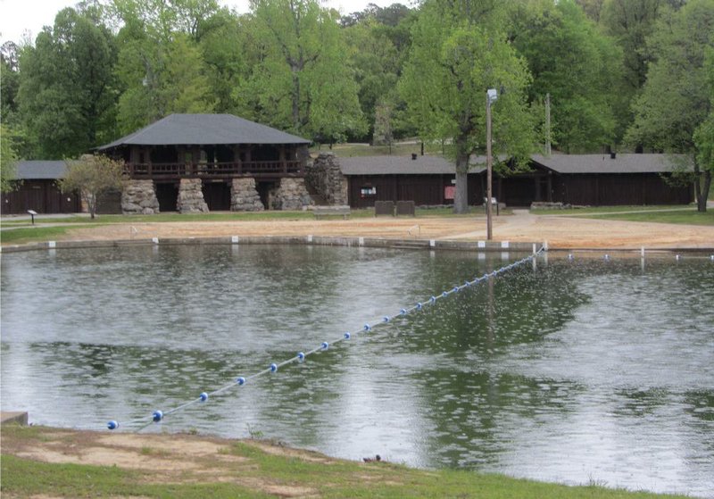
Six state parks are located along or near the ridge, among them namesake Crowley's Ridge State Park. Nine miles west of Paragould, it is the burial site of Benjamin F. Crowley, who settled in what became Greene County with his wife and eight children in 1821.
Locals probably began referring to the upland as Crowley's Ridge sometime before his death in 1842. He and his wife are buried in Shiloh Cemetery within the park, also the site of his imposing chimney-like memorial marker. The park is popular for fishing and swimming, its most impressive structure being the massive lakeside Civilian Conservation Corps Pavilion, built in the 1930s of log and stone.
Three other state parks along the parkway are primarily recreational. Village Creek State Park, southeast of Wynne, features 27 holes of golf along with two fishing and swimming lakes. Lake Poinsett State Park, east of Harrisburg, is prized for its bass, crappie and bream fishing. That's also the case at Lake Frierson State Park, north of Jonesboro.
History is the focus at Louisiana Purchase State Park, west of Marvell. A marker at this swamp location preserves the initial point from which surveys of the Louisiana Purchase territory were made. Prehistory comes to the fore east of Wynne at Parkin Archeological State Park, site of an American Indian settlement from the 11th to 16th centuries.
The parkway also leads to Civil War battlefields, black heritage sites and wildlife management areas. Decent dining can be found in towns along the way, including Marianna, Forrest City, Wynne, Jonesboro, Paragould and Piggott.
On the south edge of Jonesboro, flora and fauna are spotlighted at Forrest L. Wood Crowley's Ridge Nature Center, run by the Arkansas Game and Fish Commission. Its star attraction is a two-story diorama that demonstrates rainfall runoff and the resulting erosion that constantly reshapes the ridge. A 16-minute movie tells the story in two-dimensional fashion.
Information on Crowley's Ridge Parkway is available from Arkansas Delta Byways. Call (870) 972-2803 or visit deltabyways.com.
Crowley's Ridge State Park, just off U.S. 412 nine miles west of Paragould, offers a pair of duplex housekeeping cabins and 26 campsites. For more information, call (870) 573-6751 or visit arkansasstateparks.com.
Forrest L. Wood Crowley's Ridge Nature Center, 600 E. Lawson Road, Jonesboro, is open 8:30 a.m.-4:30 p.m. Tuesday-Saturday, 1-5 p.m. Sunday.
Admission is free. Call (870) 933-6787 or visit crowleysridge.org.
Weekend on 06/18/2015