Severe weather may arrive in Arkansas later than originally predicted Tuesday, according to the National Weather Service in North Little Rock.
Thunderstorms that will possibly bring super cells, large hail, damaging winds and tornadoes will now begin between 5 and 9 p.m. on Tuesday, National Weather Service Science and Operations Officer Chris Buonanno said in an email.
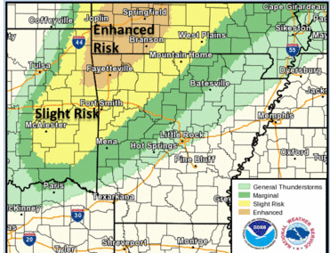
The hardest-hit areas appear to be in extreme Northwest Arkansas and the Storm Prediction Center has categorized this area as an enhanced risk, one category below moderate, the email states.
This area will be northwest of a line from Polk to Fulton counties and will include the towns of Waldron, Clarksville, Jasper, Marshall, Harrison and Mountain Home, Buonanno said.
Thunderstorms will also be possible in central Arkansas starting Tuesday night.
An additional risk for severe weather is possibly again on Wednesday afternoon, the email states.
Storms will move in behind a cold front, which limits the threat of severe weather that the National Weather Service predicts will start as large hail before transitioning into damaging winds, Buonanno said.
This cold front will bring considerably colder temperatures with a chance for frost across the state Saturday and Sunday, the email states.