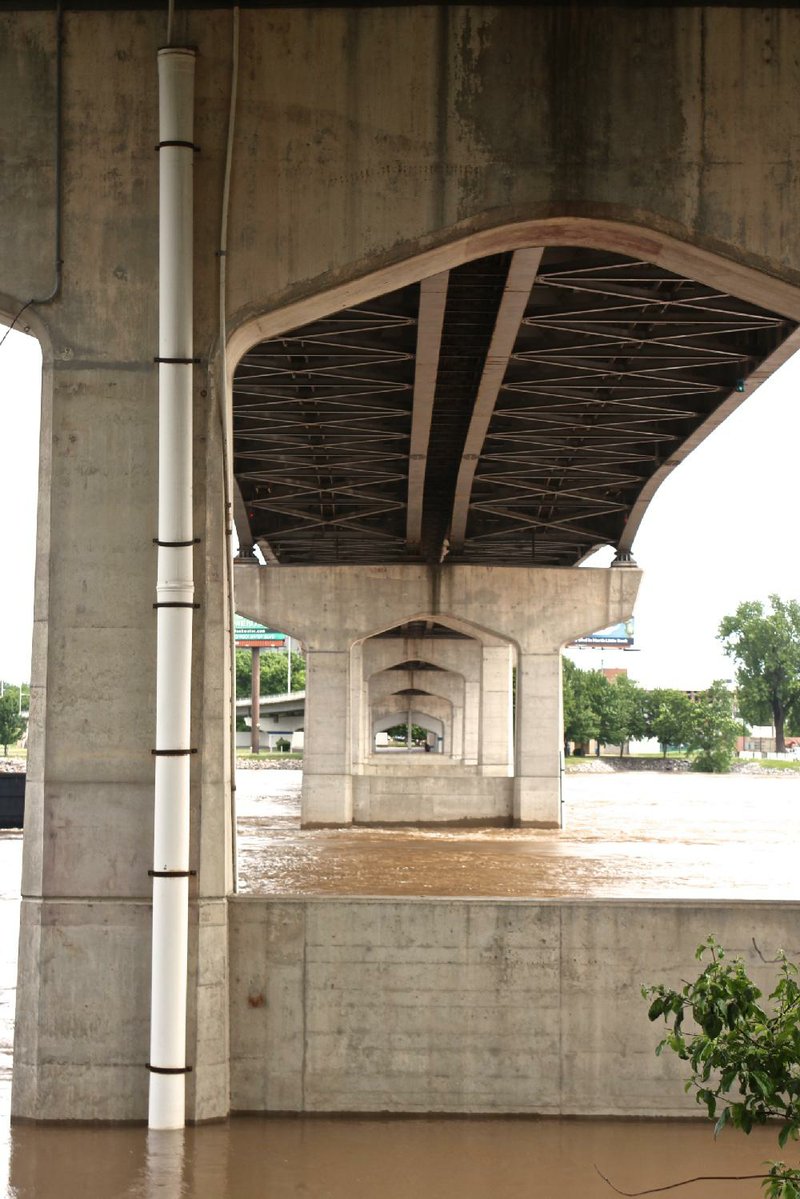
With much of North Little Rock's River Trail underwater and Little Rock's Bill Clark Wetlands more wet than land, it didn't take a meteorologist to know the Arkansas River was way up last week.
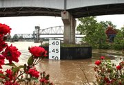
But National Weather Service meteorologists knew exactly how up it was, and they were able to forecast the day and hour at which the river would crest. Also, they knew it wouldn't top out higher than 21 feet at downtown Little Rock. In fact, the river reached 20.28 feet before beginning to drop -- as predicted Wednesday afternoon.
How did they know all that?
The short answer is river gauges -- devices that monitor rivers and streams in Arkansas and surrounding states.
The long answer involves those gauges and also the U.S. Geological Survey and the U.S. Army Corps of Engineers. But Tabitha Clarke, senior service hydrologist at the weather service's River Forecast Center in North Little Rock, said, "We forecast for the river levels off the river gauges."
So let's focus on the gauges.
Boaters, anglers and alert geography students know it's smart to get current gauge readings for any stream one plans to float, in case the water's too high or low for safety. Water levels matter so much to so many other people (land managers, farmers, park employees) that the Arkansas Democrat-Gazette lists them as part of its daily weather box on the back of the Business section.
The weather service has a website where one can see each day's gauge readings and predictions for the more than 50 gauges in Arkansas (srh.noaa.gov/abrfc).
The service's reports for Little Rock were based on readings from what's known as the Little Rock river gauge -- a tiny square on the website's map. Zooming in, one can ascertain that the gauge is on or near the southern end of the Main Street Bridge.
Can we see it from the shore?
Is it like a yardstick? A dipstick?
Does someone from the weather service go to the bridge every hour on the hour to take a reading?
Tactfully refusing to laugh, Clarke said, "Typically, I don't." Instead, weather service forecasters interpret river-level data that is relayed from the U.S. Geological Survey's computer system. There are different types of gauges, she said, and while some are basic staffs "just like rulers sticking out of the water," the Little Rock gauge is a modern-ish thing that automatically collects data and ships it to the Geological Survey via satellite.
"They've got a solar panel there that keeps the battery going," she said. "The [hourly reading] comes from the satellite into their system, and they do conversions, and then it gets into our system. It calculates it from the flow and converts it to a 'stage' so we can use it to help people understand what a flood stage is and levels."
The Geological Survey maintains this gauge for the Corps of Engineers. "Whenever the gauges go out, they're the ones we call," Clarke said.
She added that she doesn't know exactly what the Little Rock river gauge looks like, but -- for certain -- it is not the big white measuring sticks one sees affixed to a pier or on the huge round and black barge bumpers in front of the piers of the Main Street Bridge.
"That board is the navigation board that the Corps puts up for the barges. You'll see those around the state at the bridges," said Bill Baldwin, Little Rock field services unit chief for the Geological Survey. It indicates clearance below the span, and it's posted in case barge captains have any doubt whether their barges will fit.
He said the river gauge is not hard to spot, if you know to go to the Little Rock Sculpture Garden and walk toward the western edge of the Main Street Bridge. Find a sign reading "Native Plant Restoration Area" on the bank under the bridge. Look north.
"You go down there and it's on the first pier that's in the water," Baldwin said.
Just in case there's any confusion, "The pier is the thing that's holding the bridge up."
He continued, "You'll see two white pipes. They're not real small. They're probably 4-inch pipes, and they're running from the top of the pier cap down into the water. If you look real close, you'll see like an old structure on top of the pier cap. Years ago, I don't know how they did it, they built this thing on top of the pier cap, and that's our gauge.
"That gauge is pretty old."
Baldwin said the National Weather Service began measuring river levels in the same spot in 1873 and, no doubt, back then, planted a ruler in the riverbed. (Three bridges have stood on the same site, and the first, known as the Free Bridge, was completed in 1897 to carry foot and wagon traffic.)
Today the gauge doesn't measure the river from the bed up. Instead, it checks river stage relevant to a known point. At some gauges, the point is arbitrary, but "for this gauge it's the elevation of water above mean sea level."
The gauge runs on a solar-powered battery whose collection panel can be seen on the western side of the pier cap, next to a red rectangle painted on the concrete and under a long projecting arm. "The arm sticking out is just a little GPS antenna to correct the time on it for the satellite," Baldwin said.
The gauge "shoots a signal hourly," he said, but it's not a report on how fast the water is moving, or flow; it's just the river stage.
Geological Survey technicians measure the river flow at Murray Lock and Dam. "You'll see a pretty good-size boat and it should be the only boat out there" on days with small craft advisories because of dangerously high water. "What they're doing is measuring flow that's coming through the dam."
COMBINED DATA
Combined with the river stage reports from Little Rock and gauges west along the river into Oklahoma, the forecasters predict how much and when the river will change.
What if the Little Rock gauge malfunctions? Chances are, Baldwin gets a call from Clarke.
"The way we get into the gauge is we have to walk a catwalk" reached by climbing a ladder on a different pier. "We climb the ladder, walk the catwalk, and when you get down to the second pier you're out and walking toward the Main Street Bridge on that pier." They know they've found the gauge when they see something "odd, something odd up there compared to other piers."
Little Rock's backup system is "what we call a wire weight gauge. ... Our wire weight is on either a bridge rail or, in the case of Little Rock, it's on the pier cap. It's a box up there, and it's got a weight in this box, and you lower this weight, and it's got a counter on the side and when it hits the water, you take that number and you have your stage and you compare it to what the satellite is recording."
Don't call the U.S. Geological Survey to ask when the river will rise or fall.
"We save the forecasting and predicting for the weather service and the Corps," he said. "People call us asking those questions and I usually refer them to Tabitha."
ActiveStyle on 05/18/2015