Storms that produced two tornadoes in Yell County on Monday dumped more rain overnight in the western half of the state and caused the Arkansas River to rise above flood stage again Tuesday.
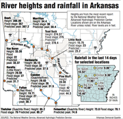
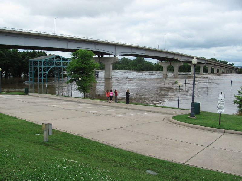
In Fort Smith, where more than 18 inches of rain has fallen this month, the river crested at 33.2 feet Tuesday -- 11 feet above flood stage -- and began receding slowly that afternoon.
Fort Smith City Administrator Ray Gosack said more than a foot of water was reported in a home in the Riverlyn area because Mill Creek and May Branch -- both drainage ways to the Arkansas River -- were flooded.
Farther downstream, the U.S. Army Corps of Engineers is preparing for river levels to rise several feet above flood stages.
No locks and dams were closed Tuesday, said Corps spokesman Laurie Driver, but a small-craft advisory for the river will continue for a few weeks because of the rapid currents. The river flowed at a rate of 310,000 cubic feet per second in Fort Smith on Tuesday afternoon. The average flow there is about 40,000 to 50,000 cubic feet per second.
Before Monday's storm, the river began to recede from heavy rainfall two weeks ago. More than 9 inches of rain deluged Fort Smith and eastern Oklahoma then, sending torrents of runoff into the Arkansas River Valley.
The river at Little Rock is expected to crest at 23.2 feet Thursday -- about 3 feet higher than its crest on May 13. Flood stage is 23 feet.
The heavy storms, which stretched from the Texas Gulf Coast to northern Oklahoma, blasted into western Arkansas on Monday afternoon with reported winds from 70 to 80 mph.
More than 50,000 Arkansans were without power at the peak of the storm.
Entergy Arkansas reported that 29,477 homes and businesses were without service at its peak at 9:45 p.m. Monday, spokesman Sally Graham said, with 8,000 power disruptions in Garland County alone. Graham said all customers should have power restored by this evening.
Southwestern Electric Power Co. had 11,500 service disruptions, spokesman Scott McCloud said.
Electric Cooperatives of Arkansas reported 6,500 homes and businesses without service mostly in Saline, Scott and Sevier counties, cooperative spokesman Rob Roedel said.
The storms downed trees and power lines across western and central Arkansas.
Two tornadoes briefly touched down southeast of Ola at about 7 p.m. Monday, damaging a home owned by Dusty Walker and destroying several of his chicken houses and vehicles, said Jeff Gilkey, Yell County Office of Emergency Management coordinator.
No one was injured.
"We got lucky," Gilkey said.
The National Weather Service in North Little Rock rated both tornadoes at EF1 after a survey team inspected damage there Tuesday morning.
One tornado with wind speeds of 90-95 mph traveled four-tenths of a mile about 3.5 miles southeast of Ola. The second twister cut a 250-yard wide path for about 1.9 miles about 3.1 miles southeast of the Yell County town with wind speeds of 105-110 mph.
Shannon Walker said she and her husband had just arrived home at the base of Ola Mountain and were putting a boat in their garage when she spotted the tornado.
"We heard it and then saw it coming over the mountain," she said. "It was so quick.
"It looked huge. It was so close."
She said she heard tornado sirens go off just as she saw the storm approach.
On Tuesday, Gilkey drove around looking at damage.
"We've got trees down throughout the county," he said.
In addition to storm damage, the county also received up to 2 inches of rain. Officials closed Arkansas 28 between Plainview and Rover in the southern half of the county after water from the full Nimrod Lake overflowed into the Fourche LaFave River.
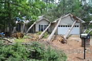
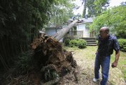
In Little Rock, high winds topped a large pine tree into a house at 6521 Kenwood Drive. Owner Jim Bell rents out the house and said residents of the home were not injured.
The tree crashed through the roof, into a bedroom and kitchen. Bell said he had removed several trees from the property earlier because they were "leaning" and he feared they may fall.
Public works departments in cities throughout the state removed down trees and tree limbs. Spokesmen for departments in Bryant, Mayflower, Maumelle, North Little Rock and Hot Springs all said damage did not exceed anything they had seen in previous storms, however.
"We missed another one," said Carl Rossini, chief of the Mayflower Volunteer Fire Department. "Thank goodness."
A lightning strike damaged a generator at the Ouachita Water Treatment plant, temporarily forcing a mandatory water conservation for Hot Springs Municipal Utilities customers in Hot Springs and Garland County, according to a news release from a Hot Springs spokesman.
Workers replaced the generator Tuesday morning, and plant officials asked that residents voluntarily conserve water until tanks reached normal levels, which was expected to occur Tuesday evening.
Weather service meteorologists were originally concerned that rainfall accumulations would be higher, especially in southwestern Arkansas, where the Red River is rising rapidly. However, the storm system "sped up" in developing and moved quickly toward the northeast.
"We traded heavy rainfall and a slow-moving system, with high winds in a fast system," said National Weather Service meteorologist Mario Valverde in Shreveport.
However, more rain is expected in the area for this weekend, he said.
"We've seen 20 inches of rain in the past 30 days in eastern Texas," Valverde said. "And we'll get more. That water has to go somewhere."
The Red River at Pecan Point in DeKalb, Texas, will crest at 34.1 feet Thursday, 9 feet above flood stage. At Index, a river gauge along the Texas and Arkansas border in Miller County, the river is expected to crest at 30 feet on Monday. Further downstream in Fulton, it is predicted to climb to 30.7 feet by Saturday.
"If we get another four to five inches of rain over the next several days, we're going to see problems," Valverde said.
A Section on 05/27/2015