U.S. Army Corps of Engineers officials closed two locks and dams on the Arkansas River on Wednesday as water released upstream from Oklahoma flowed into the already-flooded waterway.
The facilities at Morrilton and Toad Suck closed to barge traffic because of the high water and current.
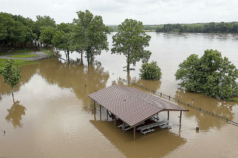
"It's on the rise again," said a worker at the Toad Suck Ferry Lock and Dam No. 8. "It's coming back up."
The Arkansas River first flooded nearly three weeks ago when storms dumped up to 9 inches of rain on Fort Smith and the river valley. Additional storms in Arkansas and Oklahoma have kept the river fluctuating since.
On Monday, heavy storms that spawned two tornadoes in Yell County added 2 to 3 inches of rain in the Arkansas River Valley.
Water is now beginning to gradually recede upstream. The river dropped 2 feet in Van Buren on Wednesday, going from 33.2 feet to 31.1 feet. The river crested there at 33.4 feet Tuesday evening. Flood stage in Van Buren is 22 feet.
National Weather Service hydrologists in North Little Rock expect that the river will crest at 5 feet above flood stage this morning in Dardanelle and 8 feet above flood stage this afternoon in Morrilton.
Little Rock's crest of 23.2 feet Saturday will be above the flood stage of 23 feet.
The Corps has issued a small-craft advisory for the river since May 8 because of the rapid flow.
At Ozark in Franklin County, the river raged at 370,000 cubic feet per second Wednesday, said Jay Woods, a spokesman for the Corps. The normal rate of the river there is about 40,000 cubic feet per second.
The river flowed at 261,000 cubic feet per second in Little Rock on Wednesday afternoon, Woods said.
"The water is working its way down here," he said. "We're going to see higher flows coming."
Jeff Caplinger, the projects coordinator for the North Little Rock Parks and Recreation Department, said floodwaters have forced the closure of parts of the Arkansas River Trail between Burns Park and the Big Dam Bridge. Soccer fields at Burns Park also are submerged, he said.
Workers had just cleaned the trail and the park of silt and debris left from flooding earlier this month.
"I've never seen it like this before," said Caplinger, who has worked at the parks department for 11 years. "In the past, it would come up, flood and then go down.
"This time it stays," he said. "This is the highest I've seen it."
Officials forecast that the Arkansas River will crest Friday in Pine Bluff at 44.3 feet, more than a foot higher than the previous crest of 43.1 feet on May 14. Then, water lapped against homes along the river and forced the closure of the Pine Bluff Regional Park.
Friday's crest will be the sixth-highest mark the river has reached in the Jefferson County town. Flood stage there is 42 feet.
Conway County flood plain manager Randy Stires spent Wednesday inspecting levees along the Arkansas River, checking for any leaks or weaknesses.
He said the levees were withstanding the water's pressure so far.
"They are holding up well, considering all the water we've had this month," Stires said. "There's been so much water, but there's no indication of any problems that I can see now.
"When we inspect them again later when the water goes down, though, I expect we'll find some damage," he said.
The rhythm to the changes in the river level may be helping the levee system hold up, he added.
"We get rains, the river goes up and then we get a few days to get the river out," he said. "If we got something like quick, heavy rains from here to Oklahoma, we'd see some problems."
Because of all the rain falling lately, moisture-laden soil is adding to the buildup that's producing storms, said National Weather Service meteorologist Julie Lesko of North Little Rock.
"These storms have produced a lot of rain," she said. "There's a lot of moisture to work with. Water on the ground evaporates and helps produce more storms."
She said the recent storms have been slow-moving, which adds more rain to already soaked ground.
In Brookland on Wednesday afternoon, 3 inches of rain fell in about 30 minutes, said Mayor Kenneth Jones. The heavy downpour flooded neighborhoods in the small Craighead County town, and water lapped over U.S. 49B near Brookland High School.
"I had never seen it rain so hard," Jones said. "It opened up right over us. It was a real gully washer."
At least six houses had water pouring into carports, and several driveways were washed out, he said.
Meanwhile, workers in Garland County continued cleaning up trees toppled by Monday's heavy storms.
Winds topped 70 mph near Hot Springs Village on Monday evening, said Bo Robertson, coordinator of the Garland County Office of Emergency Management. Trees weakened by the rain-soaked ground fell, taking down power lines, too.
"I rode the storm out in my truck in a parking lot," Robertson said. "The winds shook my truck badly."
Cleanup crews had to wait until Entergy Arkansas utility workers ensured that electricity was off on downed power lines before clearing storm debris.
"We're still clearing things, but we're very lucky with this round of storms that no one was hurt," Robertson said.
More rain is expected later this weekend and next week, with "pop-up showers" -- quick, short-lived storms fueled by abundant moisture and high temperatures -- throughout the state, Lesko said. A cold front also will make its way into the state Friday.
"We are in an unsettled condition," she said. "We have moisture from the Gulf, southeast winds and plenty of ground water. It all adds up for thunderstorm activity to be high."
There is a benefit to the rain, she noted. The heavy moisture now could keep temperatures down this summer, Lesko said.
In 2009, when spring rains soaked the state, the mercury didn't break 100 degrees all summer.
"I'm not saying that will definitely happen this year, but the amount of rain we have had could put us on track for a summer similar to 2009. It's a possibility."
A Section on 05/28/2015