The rising Red River prompted scores of Garland residents to evacuate the small Miller County town Thursday, and officials kept a close watch on levees along the river.
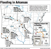
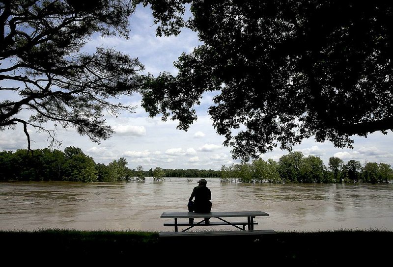
The Arkansas River also is likely to swell to flood stage in Little Rock and reach more than 2 feet above flood stage in Pine Bluff by this evening.
Hydrologists forecast the Red River to rise through the weekend, topping 30 feet Sunday evening in Fulton
— the closest river gauge to Garland. Flood stage there is 27 feet. The river is now predicted to crest at 32 feet Wednesday, provided more heavy rain doesn’t fall to the west and flow downstream.
“We aren’t ordering people to leave, but we are encouraging them,” Garland Mayor Tyeshekka Antwine said Thursday morning. “It’s not looking good.”
She said some residents chose to stay with relatives or at hotels in Texarkana, some 22 miles away.
“We’re planning for the worst but hoping for the best,” Antwine said. “I’m letting everyone know it’s best to get out of town.”
Volunteers began placing sandbags Thursday at the Red River levee around Garland in anticipation of the rising waters. The town of 250 is perched on the western shore of the river.
To the north, Hempstead County Judge Haskell Morse received more than 100 cubic yards of sand from the Arkansas Highway and Transportation Department, and volunteers began filling 3,000 sandbags to stack along the Red River levees there.
Crews also drove along the levees, inspecting for any “boils,” or leaks, and set up two pumps with 8-inch-wide hoses to help remove water if the river tops the levee.
“It’s supposed to reach 32 feet,” Morse said. “If it continues raining, we may see it rise more.”
Nearby, Lafayette County Office of Emergency Management coordinator Danny Ormand also checked levees.
“We’re identifying a few sites that may be dangerous if the river gets too high,” he said. “We want to stay ahead of the game.”
He said several residents who live on land inside the Red River levee system already have moved out.
“There’s no mandatory evacuation, but people who live inside the levees know the river,” Ormand said. “We’re going to get a lot of water. We hope to hold it inside the levees.”
Upstream at DeKalb, Texas, the Red River crested at 34.7 feet Thursday afternoon
— a foot shy of the record level set there on Feb. 15, 1938. Hydrologists say the river will gradually begin receding.
Highway officials closed 5 miles of Arkansas 41 in Little River County on Thursday morning because of the rising Red River. The road is closed from the Arkansas and Texas state line to Mud Line Road near Foreman.
Jeff Whatley, a spokesman for the Arkansas Highway and Transportation Department, said officials are watching water levels at the U.S. 71 Red River bridge near Texarkana and will close that road if the river reaches the bridge.
In Horatio, the Little River — which merges downstream with the Red River — began receding. By nightfall, the river dropped more than a foot from its crest of 31.4 feet Wednesday evening.
“It’s rolling,” Horatio city water clerk Anita Billingsley said of the churning river.
Meanwhile, National Weather Service meteorologists are calling for more rain from tonight through Tuesday.
Rain fell in much of the state Thursday as a system of storms that formed in Oklahoma slowly pushed across Arkansas. Many areas measured only a quarter of an inch. Little Rock saw at least three-tenths of an inch by Thursday evening.
“They didn’t dump buckets of rain,” said weather service meteorologist Julie Lesko of North Little Rock of the day’s storms. “It shouldn’t have affected the river levels. We’re more concerned with the rain coming this weekend.”
She said much of the state will get up to an inch and a half of rain today through Sunday.
“The ground is already saturated,” she said. “We are in a pattern where the rivers crest and then begin falling below flood stage when the next system comes and turns the river around.”
The Arkansas River first flooded nearly three weeks ago, when up to 9 inches of rain fell in western Arkansas. More rain fell Memorial Day, sending another surge of water into the river.
U.S. Army Corps of Engineers officials also are releasing torrents from reservoirs along the Arkansas River in Oklahoma, adding to the already flooding waters in Arkansas.
At Murray Lock and Dam in Little Rock, the river raged at 300,000 cubic feet per second — up from 261,000 Wednesday, said Corps spokesman Jay Woods. It is expected to increase to 315,000 cubic feet per second today.
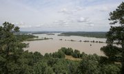
Water levels farther upstream crested Thursday. Dardanelle’s mark of 37.71 feet was the third-highest recorded measurement.
Leah Marruffo, an employee of the Petit Jean State Park visitor center, could see the Arkansas River from her spot atop Petit Jean Mountain on Thursday afternoon.
“You can see that it’s high, but you don’t get the full impact until you cross the [Arkansas 9] river bridge at Morrilton,” she said. “There are complete hayfields that are underwater now. When you go across it, it hits you. It’s, ‘whoa.’”
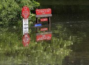
Kathleen Deluca watched the river continue to rise at her Lewisburg Bay RV park in Morrilton on Thursday afternoon. The rising waters forced five RVs to evacuate earlier this month.
“Those spots are underwater,” she said. “We’ve got water up to mailboxes now, and we’ve got 3 to 4 feet covering our main road.”
The river crested at 38.3 feet in Morrilton early Thursday, the eighth-highest mark recorded there. Flood stage in Morrilton is 30 feet.
The river is predicted to dip below flood stage by Tuesday.
The North Little Rock section of the Arkansas River Trail remained closed Thursday between the Big Rock Quarry and the Big Dam Bridge. Jeff Caplinger, project coordinator for the North Little Rock Parks and Recreation Department, said he expects the trail to reopen Wednesday.
The Big Dam Bridge will be accessible only from the Little Rock side of the Arkansas River, he said.
In Little Rock, the river walk at the Witt Stephens Jr. Central Arkansas Nature Center was underwater Thursday, said Chris Bills, a volunteer who works at the center.
“Animals are all going to high ground, and more water’s coming,” he said.
Downstream, Eric Maynard planned to deliver food to animals at the Delta Rivers Nature Center in Pine Bluff by boat. Floodwaters have covered roads leading to the center and Pine Bluff Regional Park, forcing the closure of both.
“Water is not in the center, but it’s high on the grounds,” Maynard said.
Officials forecast that the Arkansas River will crest today in Pine Bluff at 44.3 feet.
Maynard said he saw hundreds of earthworms inch to higher ground as the river began rising.
“I’ve seen more snakes in the past two weeks than I’ve seen in the last two years,” he said.
Maynard and other Arkansas Game and Fish Commission workers will transport food by boat to the nature center’s eagles, owls, hawks and other birds of prey, along with snakes, lizards and other animals in its aquarium until the roads clear and the workers can drive in.
Jefferson County deputies have resumed patrolling flooded areas along Riverside Drive and Island Harbor in Pine Bluff, said Karen Blevins, coordinator for the Jefferson County Office of Emergency Management.
“Most of those who live there know the river levels,” Blevins said. “They knew to move their stuff to higher ground, and they’ve already gotten out.
“We will have several more homes affected this time by the flooding than last.”
BEFORE AND AFTER: Arkansas River flooding
- http://www.arkansas…">See the river levels this week versus normal levels