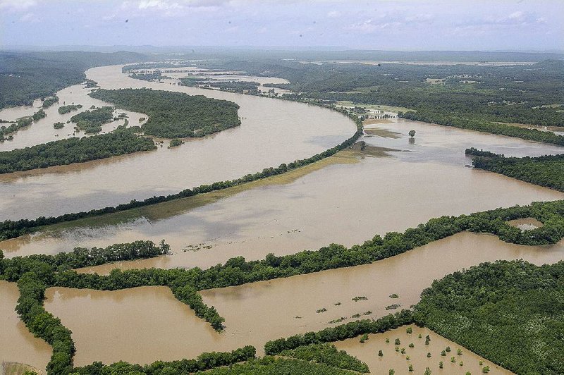
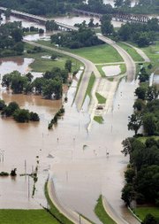
Gov. Asa Hutchinson declared state disaster areas in five counties Friday because of flooding, including Faulkner County, after he flew over the swollen Arkansas River between Morrilton and Toad Suck.
Hutchinson was forced to cancel an earlier flight Friday over the rising Red River because of fog and rain.
"It was an impressive tour," said J.R. Davis, Hutchinson's spokesman. "Obviously, the governor wanted to see the extent of the flooding. I think it was a bit of a surprise to see how widespread the flooding is."
The governor included Crawford and Logan counties because of flash flooding in western Arkansas earlier in the week, and Lafayette and Miller counties in southwestern Arkansas in anticipation of near-record flooding.
The Red River rose more than 2 feet Thursday evening in Garland, prompting officials to plan an evacuation of elderly residents and those with medical problems, said Carla Jenkins, a spokesman for Miller County.
"The water is coming," she said. "Garland city is our worst area. We are expecting it to get bad.
"Everyone is trying to get to higher ground," she said.
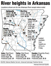
On Friday evening, the Red River measured at 24.8 feet at Fulton, the nearest gauge site to Garland. National Weather Service hydrologists expect it to climb to 32.6 feet by Wednesday. Flood stage there is 27 feet.
Upstream at Index, the river measured 27.5 feet Friday evening and was expected to crest at 31 feet Tuesday, the third-highest mark recorded and about 3 feet below the record set Feb. 23, 1938.
"We're expecting a significant flood," said Larry Pritchett of the Miller County Office of Emergency Management. "It's bad. The ground is saturated, and the rain keeps falling. The water has nowhere to go but up."
Meteorologists are calling for rain today and Sunday. Up to 2 inches is expected to fall in western Arkansas and in eastern Oklahoma and Tennessee, said National Weather Service meteorologist Dave Scheibe of North Little Rock.
That water will run off the saturated ground and quickly into river basins.
"There's a chance the Red River will go higher than expected," said National Weather Service meteorologist Cynthia Palmer of Shreveport. "It all depends upon how much falls further west."
Palmer said 15 to 20 inches of rain has fallen in Texas and Oklahoma in May, filling reservoirs to the brim and pouring into streams and creeks and eventually the Red River system.
The deluge has helped drought conditions in Texas. In March, 44 percent of the state was considered in some form of drought. On Thursday, the National Drought Mitigation Center -- a University of Nebraska-Lincoln-based organization that evaluates drought conditions in the United States -- said only 5.4 percent of Texas now remains in drought.
In Texas, the U.S. Army Corps of Engineers released water into the Red River basin from Wright Patman Lake on Friday at a rate of 100,000 to 120,000 cubic feet per second, Palmer said.
"That water has to go somewhere," she said.
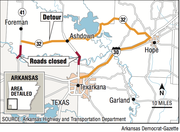
Meanwhile Friday, the Arkansas Highway and Transportation Department closed 2.5 miles of U.S. 71 in Little River County after water from the Red River flooded both the southbound and northbound lanes.
Officials also closed 5 miles of Arkansas 41 from the Arkansas and Texas state line to Mud Line Road near Foreman in Little River County on Thursday.
Highway Department Director Scott Bennett said his staff was making preparations in case the Red River covers Interstate 30 just west of the Hempstead County community of Fulton.
"We don't think the water is going to get over I-30," Bennett said during a special meeting Friday of the Arkansas Highway Commission. "But we will be ready if it does."
Preparations include installing work stations with telephones and laptops in the Arkansas Highway Police training room at the department's Little Rock headquarters to handle high volumes of calls from the public should the interstate be closed, Highway Department spokesman Danny Straessle said.
A similar plan was established in 2011, when the flooded White River forced the closure of Interstate 40 near DeValls Bluff for several days.
On Friday, emergency officials toured Red River levees from Fulton south to ensure their safety, Pritchett said.
"We know where the weaker spots are, so we're checking them," he said.
He said he feared more rain would raise the river above the flood stage of 1990 -- a level he described as devastating.
"For the next 48 hours, we will be working to get everyone out of Garland."
Corps officials closed four locks and dams on the Arkansas River because of the flooding. Locks are closed at Fort Smith, Morrilton, Toad Suck and Pine Bluff.
Periodic releases of water from flooded Oklahoma reservoirs upstream have kept the Arkansas River levels fluctuating.
"The lakes and reservoirs are getting full in Oklahoma," Corps spokesman Laurie Driver said. "We are waiting for the crests to subside before we release more if we can.
"If rain falls below the areas with reservoirs, it will just come down the river uncontrolled."
At Fort Smith, the river's flow measured at 300,000 cubic feet per second Friday afternoon. In Dardanelle, it roared at 360,000 cubic feet per second, and in Little Rock, the Arkansas River measured at 320,000 cubic feet per second.
The rate of flow on the river is usually between 40,000 and 50,000 cubic feet per second.
At Toad Suck Lock and Dam, the Arkansas River climbed Friday to 280 feet, its third-highest peak, before beginning to recede.
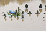
Water cut off access to several homes on Jones Road, Faulkner County spokesman Tom Anderson said. No homes were damaged, but officials were considering boating in food and supplies if the water remained above the road during the weekend.
"It's going to take a long while before the water goes down," Anderson said.
In Little Rock, up to 3 feet of water covering the Arkansas River Trail forced its closure from the Two Rivers Park Bridge westward through a wooded trail to the restrooms, city spokesman Luis Gonzalez said.
The Rebsamen Golf Course in Little Rock also closed because of flooding, Gonzalez said.
The Arkansas River Trail in North Little Rock also remained closed between the Big Rock Quarry and the Big Dam Bridge.
Storm damage also prompted Ouachita National Forest officials to close the day-use area at Albert Pike Recreation Area in Montgomery County and the nearby Winding Stair trailhead on the Little Missouri River north of Langley until further notice.
High winds knocked out power at Albert Pike and made other areas of the forest impassable because of toppled trees.
The area was the site of a flash flood June 11, 2010, that swept the Little Missouri River through campsites and killed 20 people.
In Jefferson County, rising waters entered homes in Pine Bluff's Island Harbor Estates and in Raydell, said Karen Blevins of the Office of Emergency Management. Sightseeing boaters were causing wakes that washed the river water into homes.
She said Jefferson County deputies are patrolling and stopping any sightseers from getting too close.
"There's quite a bit of water," she said. "We're ready to send it on down to the Mississippi River."
However, high waters are likely to remain for quite some time, meteorologists said.
This month's heavy rains have soaked the ground and provided more moisture for recurring storms to develop. Another round of storms formed Friday evening in west Arkansas, resulting in a tornado warning for Washington County after weather service radar detected rotating winds.
The development of El Nino, the warming of Pacific Ocean waters near the equator, also is likely to deliver more rain to Arkansas this summer. The weather phenomenon alters the jet stream, a strong upper-level current of cold air, and causes it to dip farther south. That movement combined with warm, moist air from the Gulf of Mexico can create a cycle of storms.
"We're going to see a better chance of wetter weather for June, July and August," Palmer said at the weather service in Shreveport. "There will be continuous formations of upper level lows in our area that bring rain.
"The Red River could be above flood stage through July 4," she said. "We could be in for a long, wet summer."
Information for this article was contributed by Noel Oman of the Arkansas Democrat-Gazette.
A Section on 05/30/2015