As Arkansans continued to evacuate along the flooding Red and Arkansas rivers this weekend, meteorologists predicted slightly higher water levels for the rivers Wednesday and Thursday.
Heavy rains across the south-central United States and most of Arkansas this spring have led to flooding all month long. Nearly all of Arkansas has experienced well over 100 percent of its average precipitation for this time of year, according to National Weather Service data.
In Little Rock, flooding has closed portions of Two Rivers Park, Rebsamen Park Golf Course and portions of the Arkansas River Trail.
In Texas, floodwaters have submerged interstates, and in Oklahoma, waters have overfilled lakes.
Rain remained in the weekend's forecast for much of south and central Arkansas, but the National Weather Service is anticipating a few dry days at the beginning of the week, meteorologist Charles Dayton said.
That won't be the end of the flooding, however.
Rain in Oklahoma has led the U.S. Army Corps of Engineers to release water into the Arkansas River and the Red River from lakes that are too full.
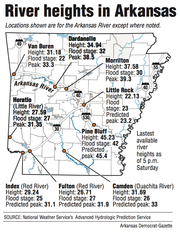
Eric Maynard and other employees are taking boats just to feed the animals at the Delta Rivers Nature Center in Pine Bluff, where the river crested Saturday evening at just over 45 feet. Flood stage is 42 feet.
"It looks like an island," Maynard said Saturday. "There's water in our parking lot. There are fish swimming up above the road on the bus turnaround area."
Small parts of the pathways along the nature center stick up and stand out in what is now an extension of the Arkansas River and Caney Bayou.
The water's so deep, Maynard wore hip-high boots Friday on the trail and had to stop only a short way in because the water was already reaching the top of the boots.
In Dardanelle, where the Arkansas River crested at 37.73 feet Thursday, the river is anticipated to rise again to 38.3 feet Monday, according to the National Weather Service in North Little Rock. Flood stage is 32 feet in Dardanelle.
In Morrilton, the river is set to rise to 39.2 feet early Tuesday, higher than the 38.49 feet it reached Thursday. That higher level would move the river up from moderate flood stage to major.
At Toad Suck, officials can no longer see the gauge, which is now submerged. The level there Saturday was unknown.
The Arkansas River in Little Rock will reach 23.2 feet early Wednesday, higher than the more than 22 feet it was expected to reach Saturday. The flood stage is 23 feet for that portion of the river.
In Pine Bluff, the river will reach 45.3 feet Wednesday afternoon after being expected to crest just below that Saturday evening. Higher than 45 feet is major flood stage for that area of the river.
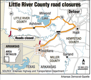
In south Arkansas along the Red River, residents of Garland, a town of 242 on the western banks of the river, have started to leave.
"The water's rising rapidly," said Larry Pritchett, Miller County Office of Emergency Management coordinator. "It doesn't look good."
"We're poised to get people out of this city right now," he added.
Evacuation isn't mandatory, but the river has reached the top of the levee in some areas, Pritchett said. Some people are waiting until the last minute to leave their homes, he said, and some might choose not to go at all.
Pritchett said he isn't sure if the water will top the levee anywhere but said it did in the 1990s.
"The Corps of Engineers said it would be as bad or worse than 1990s," he said. "We're preparing for the worst and hoping for the best."
The National Weather Service in Shreveport has predicted Red River levels well above flood stage in Arkansas, Texas and Louisiana.
The Red River is likely to crest at even higher levels by the end of the week.
Many of the projections are slightly lower than the levels experienced during the May 1990 Red River flood.
In Fulton, the nearest gauge to Garland, the river is likely to rise to nearly 32 feet by Thursday. During the May 1990 flood, the river reached 34.3 feet. Flood stage there is 27 feet, and the river was at 26.1 feet Saturday morning.
Flooding will continue to be a problem into the summer.
"After the Red River crests ... very high water stages will continue on the Red River through at least the end of July due to very high flood control reservoir pool stages across much of the Red River Basin," according to the National Weather Service's website.
On the other side of the Red River in Lafayette County, the river hasn't reached the levees yet, but farmers who live between the river and the levee have packed up and moved out, said Danny Ormand, Lafayette County Office of Emergency Management coordinator.
"It hasn't reached the levee system yet, but it is approaching that," Ormand said. "If it reaches the levels they say, we'll have some water out against the levees by first of the week."
In Mayflower in central Arkansas, neighbors in 11 homes are waiting out the floodwaters on Jones Lane, which lies just north of the Arkansas River. Their only road to the outside remains under 4 feet of water.
They haven't evacuated but have been in contact with Faulkner County officials about supplies, Faulkner County spokesman Tom Anderson said. They're riding boats to visit one another and reach the edge of the road where they can speak with county officials who are on a road grader.
"They're a close-knit group of families out there," Anderson said, estimating that about 35 people live on the street. "They're taking care of each other."
Many farmers along the river also have lost their crops in the flooding, Anderson said.
In Pine Bluff, Maynard said the Delta River Nature Center will cancel school trips this week and send employees to work in other offices across the state.
Others, like Maynard, will take the boats out every other day to feed the animals, which he said weren't in danger because the exhibits have high ground.
With river levels projected not to be too much higher than they are this weekend, Maynard is optimistic about the coming week.
"I've looked at the water levels, the projections -- the water may get into the eagle pens a little bit, but they've got some high ground in their exhibit. It doesn't look like it'll get to them," he said. "The animals are all safe and being taken care of."
Metro on 05/31/2015