6:17 P.M. UPDATE
More than 15,000 customers across Arkansas were without power as of 6:15 p.m. Tuesday, according to Entergy's website.
Garland County had the most people without power at just more than 7,000 affected, and about 1,000 customers in Pulaski County were affected.
Read Wednesday's Arkansas Democrat-Gazette for full details on today's storms.
5:31 P.M. UPDATE
A tornado warning covering parts of Phillips County has ended, according to the National Weather Service.
The warning expired at 5:25 p.m. It was originally set to last until 5:45 p.m.
5:12 P.M. UPDATE
A tornado warning covering parts of Phillips County, including Helena-West Helena, is in effect until 5:45 p.m.
The National Weather Service said a severe thunderstorm capable of producing a tornado was located near Elaine at 5:01 p.m. It was moving northeast at 45 mph.
4:51 P.M. UPDATE
North Little Rock set a daily rainfall record for Nov. 17 about 3:57 p.m. Tuesday, according to the National Weather Service in Little Rock.
Tuesday's record of 2.21 inches broke the previous record of .85 inches set Nov. 17, 1996.
4:47 P.M. UPDATE
Both northbound lanes of U.S. 67/167 are back open in Jacksonville, though one of the highway's southbound lanes remains closed between Main Street and Redmond Road, according to highway officials.
Visit ArkansasOnline's live traffic map for information on traffic in the area.
3:54 P.M. UPDATE
A tornado warning covering parts of Lonoke, Monroe and Prairie counties has ended.
The National Weather Service expired the warning at 3:52 p.m. It had originally been set to go until 4 p.m.
3:33 P.M. UPDATE
A tornado warning covering parts of Lonoke, Monroe and Prairie counties is in effect until 4 p.m.
The National Weather Service said a storm capable of producing a tornado was located about 10 miles northwest of Stuttgart at 3:24 p.m. It was moving northeast at 40 mph.
Meanwhile, officials said a single lane of U.S. 67/167 is now open in both directions in Jacksonville. High water had previously caused all lanes to be shut.
The ArkansasOnline live traffic map showed extremely slow conditions in the area.
2:58 P.M. UPDATE
U.S. 67/167 is closed in Jacksonville because of high water.
The Arkansas State Highway and Transportation Department said the highway was closed in both directions between Main Street and Redmond Road.
There was no word on when the highway was expected to reopen.
See Wednesday's Arkansas Democrat-Gazette for full coverage.
2:48 P.M. UPDATE
A tornado watch now covers a smaller portion of the state.
The National Weather Service said shortly before 3 p.m. that the watch was cancelled early for Calhoun, Cleveland, Dallas, Faulkner, Grant, Ouachita, Pulaski, Saline and Van Buren counties.
The watch remained in effect through 6 p.m. for Arkansas, Bradley, Cleburne, Desha, Drew, Jefferson, Lincoln, Lonoke, Monroe, Prairie, White and Woodruff counties.
2:48 P.M. UPDATE
A local fire department told the National Weather Service that the roof on an outdoor stage at the Perry County Fairgrounds was torn off and blown about 40 yards away. Tree damage was also reported.
One tornado warning for the Perryville and Morrilton area was allowed to expire as a storm moved eastward. It wasn't known immediately whether a tornado touched down. The region was eventually dropped from a tornado watch that covered much of the state.
— The Associated Press
2:35 P.M. UPDATE
More than 18,000 people were without power after strong storms moved through the state Tuesday.
Entergy reported more than 10,000 of its customers in Garland County lost power while more than 1,600 each were in the dark in Pulaski and Union counties.
1:40 P.M. UPDATE
The Little Rock School District has cancelled all of its after-school activities and athletic events Tuesday because of the weather.
The Little Rock School District CARE Program, which offers after-school child care, will remain open, but "parents are requested to pick up their students ... as soon as possible," district spokesman Pam Smith said in a statement.
1:21 P.M. UPDATE
Hot Springs Interim City Manager Bill Burrough told the Arkansas Democrat -Gazette a strong gust of wind shattered a large window in his City Hall office.
Burrough said he had just walked out to warn his assistant of the strong winds bending the window when it broke, sending glass "everywhere."
City Hall did not lose power, Burrough said, adding he set up a temporary office in an annex building nearby.
1:15 P.M. UPDATE
A tornado warning that had been in effect for Conway County was allowed to expire at 1:15 p.m.
There were no preliminary reports of any tornadoes touching down during the warning period, which at times covered parts of Conway, Faulkner and Perry counties.
1:02 P.M. UPDATE
The National Weather Service has canceled its tornado warning for Faulkner and Perry counties, though it is still in effect for Conway County through 1:15 p.m.
There were no preliminary reports of a tornado touching down during the warning.
1 P.M. UPDATE
Storm damage is being reported in Hot Springs.
Video posted by the Hot Springs Sentinel-Record on Facebook shows a pile of bricks scattered along the sidewalk at the corner of Orange Street and Ouachita Avenue. They appear to have been knocked off a building in the area by the storm.
The National Weather Service also reported damage to cabins on Lake Hamilton Drive in Hot Springs. Trees and power lines were also down in area.
The Hot Springs School District, meanwhile, said it was dismissing students early because of power failures on multiple campuses. Dismissal was set to begin at 1:30 p.m.
The Garland County Courthouse is also closing early for the day.
12:45 P.M. UPDATE
The National Weather Service issued a tornado warning for three counties in central Arkansas.
Parts of west central Faulkner County, northeast Perry County and southeast Conway County are under a tornado warning 1:15 p.m.
12:30 P.M. UPDATE:
Nearly 15,000 Entergy customers were without power across Arkansas as strong thunderstorms moved toward the central part of the state.
More than 11,000 customers were without power in Garland County and more than 1,000 were in the dark in Hot Spring County.
11:45 A.M. UPDATE:
The National Weather Service issued tornado watches through early Tuesday evening for 36 Arkansas counties.
Among the counties included in the watch were Pulaski, Conway, Hot Spring and Saline.
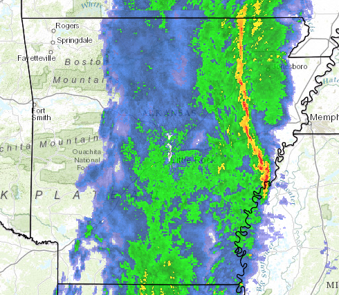
Weather service radar showed an intense band of weather known as a squall line west of Hot Springs and moving east.
A weather service meteorologist said early Tuesday the most intense weather and likelihood for tornadoes would be in southeast Arkansas later Tuesday.
10 A.M. UPDATE:
All of Arkansas is at risk for severe weather Tuesday with strong winds and possible tornadoes more likely in central, southern and eastern parts of the state, forecasters said Tuesday.
The greatest threat is in an area of "enhanced" risk covering a large swath of the state roughly south of Batesville and east of Hot Springs. There is a higher likelihood of warming temperatures ahead of the storm in that area, which includes Little Rock, the National Weather Service said.
The areas under enhanced risk may get between 4 and 5 inches of rain with wind gusts up to 40 mph Tuesday, officials said.
A squall line that will bring torrential rain as it moves east across the state was moving over the western border near Fayetteville and Texarkana around 9:45 a.m. Tuesday, according to meteorologist Charles Dalton, who works in the National Weather Service office in North Little Rock.
Dalton said the storm was showing "nothing of great concern" early in the day, but cautioned that it still had several hours to go before reaching areas in the south and east where it has the highest likelihood of producing damaging winds or tornadoes.

Video of the Swearingen Building by Richard Rasmussen of The Sentinel-Record. Officials at the scene said there were no injuries, but the building was evacuated.
Posted by The Sentinel-Record on Tuesday, November 17, 2015