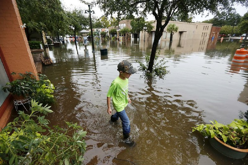
COLUMBIA, S.C. -- A dangerous rainstorm drenching the East Coast brought more misery Sunday to South Carolina -- cutting power to thousands, forcing hundreds of water rescues and closing scores of roads because of floodwaters.
Emergency management officials sent a statewide alert telling people to stay off roads and remain indoors unless their homes were in danger of flooding. Interstate highways were closed because of flooding -- including a 75-mile stretch of Interstate 95 in the eastern part of the state that is a key route connecting Miami to Washington, D.C., and New York.
"This is different than a hurricane because it is water, it is slow moving and it is sitting. We can't just move the water out," Gov. Nikki Haley said in a news conference at the headquarters of the state's Emergency Management Division.
An overnight curfew was issued for Columbia and across two adjacent counties.
Additionally, the capital city told all 375,000 of its water customers to boil water before drinking because of waterline breaks and the threat of rising water to a treatment plant. Emergency officials said later Sunday that many in Columbia were without potable water because of water main breaks, and customers may have to go without drinking water for three or four days.
At one point, nearly 30,000 customers were without power.
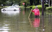
State officials said 100 people had been rescued by midmorning from vehicles after trying to cross flooded roads, while state officials reported a total of 200 swift-water rescues around the state. Columbia police said that another 200 rescue calls were pending as of midmorning.
One of the hardest-hit areas in Columbia was near Gills Creek, where a weather station recorded more than 18 inches of rain, nearly all of it in 24 hours. The creek was 10 feet above flood stage, spilling floodwaters that almost reached the stoplights at a four-lane intersection.
Hundreds of businesses, homes and apartments flooded, and dozens of boats fanned out to rescue trapped people.
The Columbia Fire Department had 140 firefighters working around the county. Fire Chief Aubrey Jenkins said he's lost count of how many rescues have been performed.
"We're just trying to get to everyone," Jenkins said. "But there are places we just haven't gotten to."
Columbia Police Chief William Holbrook said door-to-door search-and-rescue operations by police, firefighters and other emergency responders would continue today. Military vehicles were being lined up to take people to safety.
"The operation will also include overall welfare checks," he said of the "concentrated" operation, adding that crews will mark the front doors of homes with a fluorescent orange "X" once they have been searched.
State Rep. Kirkman Finlay begged for help for his district, praising first responders, but saying the state planned poorly when it knew flooding was likely.
"We have property destroyed and lives crushed," Finlay said.
Emergency shelters were being opened around the state for displaced residents, and President Barack Obama declared a state of emergency in South Carolina.
The Columbia area received the most rain overnight, with up to 14 inches reported in some places since Saturday, forecasters said. To the southeast, meanwhile, rainfall had exceeded two feet since Friday in some areas around Charleston, though conditions had improved enough that residents and business owners were allowed downtown on a limited basis.
Charleston Mayor Joe Riley said he's never seen such flooding in his 40 years as mayor.
"This was a record storm," he said. "You know the amount of rainfall that we have experienced is unprecedented. I feel very fortunate that we were able to get through this as well as we have."
At least seven weather-related deaths have been reported since rains began spreading over the Eastern Seaboard, which dodged the full fury of Hurricane Joaquin, which is veering out to sea.
One driver died on a rain-slickened road after his car crossed the centerline on a state road in western North Carolina on Saturday, according to the State Highway Patrol.
The latest death reported was that of a woman killed when her SUV was swept into floodwaters in Columbia. Richland County Coroner Gary Watts said the woman's body was found Sunday afternoon, about 12 hours after she disappeared in floodwaters near downtown Columbia.
Meanwhile, Bermuda was lashed Sunday by gusting winds and pelting rains from a weakening Hurricane Joaquin.
Residents mostly hunkered down at home after securing patio furniture and stocking up on gas and batteries as the Category 2 hurricane whipped the mid-Atlantic British territory. All flights to L.F. Wade International Airport were canceled and ferry service was closed due to rough seas. Emergency service agencies were placed on alert.
After roaring across parts of the Bahamas as a major Category 4 hurricane, Joaquin lost steam as it headed north. By late Sunday afternoon, U.S. forecasters said sustained winds had dropped to 100 mph and described the storm's eye as "ragged." Still, it was expected to bring hurricane conditions and a life-threatening storm surge to Bermuda on Sunday evening when the storm's eye passed closest to the island. The National Hurricane Center in Miami said isolated tornadoes were also possible.
As the hurricane's eye moves past Bermuda, swells kicked up by the storm will continue to affect the Bahamas and the eastern coast of the U.S. about 600 miles away.
The National Hurricane Center said that elevated water levels and big waves from Joaquin will affect the U.S. mid-Atlantic region, "causing significant beach and dune erosion with moderate coastal flooding likely."
Information for this article was contributed by Bruce Smith, Mitch Weiss, Jonathan Drew, Susanne Schafer, Josh Bell and David McFadden of The Associated Press.
A Section on 10/05/2015