Although the summer months have drawn to a close, the Arkansas Forestry Commission is stressing fire safety to the public.
The commission strongly discourages burning outdoors statewide because of a number of factors. The cooler fall temperatures tempt people to begin burning bonfires and campfires, but the risk for wildfires is still high at this time of year. Weather conditions throughout the state are what Director of Communications for the Arkansas Agriculture Department Adriane Barnes calls “a perfect storm” for wildfire risk.
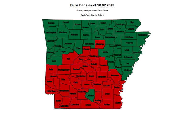
Thirty-five Arkansas counties are under burn bans as of the writing of this article. Furthermore, the state is roughly bisected into a northern area of moderate wildfire danger and a southern area of high wildfire danger, as classified by the Arkansas Forestry Commission.
Counties in the Three Rivers Edition coverage area with burn bans in effect are Pulaski, Lonoke and Cleburne.
Lack of rain, low humidity, wind and heat all contribute to fire risk in an area. These criteria, coupled with dry vegetation in the autumn months, make it so the slightest catalyst can start a blaze. Discarded cigarette butts, sparks from machinery and any open flame could lead to an out-of-hand fire in minutes.
“The reason [some counties] were moved to high fire danger is a combination of extremely dry conditions; there are some near-drought conditions in southwest Arkansas, in fact,” Barnes said. “The dryness is being coupled with gusty winds and low humidity. We have a really good formula in place for possible fire frequency.”
October and even early November are still times to be vigilant about fire safety. This time is the cusp of what Barnes calls “the second season of historic Arkansas wildfire activity.” The periods that see the highest instance of wildfires are February through April and August through October, and of course, these periods are weather dependent. So the periods can last longer or be shorter based on the weather.
“We really tell everybody, ‘Don’t burn outdoors.’ Just don’t do it until we get more rain or the conditions change,” Barnes said.
Even if someone has no official indication of the humidity level, there are signs to look for that will tell you that fire danger is particularly high. Individuals with sensitive hair can often detect changes in humidity easily, and dry skin often accompanies low humidity because moisture is sapped from the skin by low concentrations of water vapor in the air.
“You’ve got to have dry conditions and gusty winds and low humidity in order to have high fire frequency,” Barnes said. “[This week], the humidity went back above 40 percent. So our stats look like this: We had a little over 200 acres burn [last weekend]. On Monday, we had 45 acres, Tuesday, we had 38 acres. On Monday, that was five fires; on Tuesday, it was 10 fires. Relatively small fires are less frequent because we have humidity coming in and saving our bacon.”
A mobile phone is a great tool to use to determine whether or not it is safe to burn in an area. The Arkansas Forestry Commission has a handy mobile site, arkfireinfo.org/m/, that can check, either by current location or ZIP code, the fire risks in your area. Arkfireinfo.org has maps that indicate the severity of fire risk, location of prescribed burns and counties under burn bans.
It is also important to keep an eye out for fires that may be out of hand or that occur in the wilderness. The commission has a hotline set up for reporting wildfires, (800) 468-8834, and a hotline for reporting prescribed burns, (800) 830-8015. An online form is also available for reporting a prescribed burn so that forestry officials can approve and be aware of a such an event. Contact information for local AFC crews can be found by visiting forestry.arkansas.gov and choosing the “Contact Us” icon at the top right of the homepage.
Single-engine air tankers are contracted in periods of elevated wildfire danger to provide air support to the men and women working on the ground to fight fires.
Staff writer Morgan Acuff can be reached at (501) 244-4314 or macuff@arkansasonline.com.