2:15 P.M. UPDATE
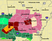
The National Weather Service has issued a tornado watch for 16 counties in southwest Arkansas.
The watch will be in effect until 10 p.m.
Forecasters issued the watch for the following counties: Union, Columbia, Lafayette, Miller, Hempstead, Nevada, Ouachita, Calhoun, Bradley, Cleveland, Dallas, Clark, Pike, Howard, Sevier and Little River.
— Jaime Dunaway
1 P.M. UPDATE
Rock Region Metro resumed its streetcar service after it was suspended for nearly an hour because of flooding in Little Rock, officials said.
The suspension, which began around noon, was the second time the streetcar service had to alter its availability Friday. Service was also delayed at 6 a.m. for an hour until lightning and storms had subsided.
Flooding in the metro area has caused many drivers to find alternate routes.
Campus Drive East and Campus Drive West on the University of Arkansas at Little Rock campus were closed for about 20 minutes Friday because of flooding.
The roads were reopened, but police recommended that students move their cars from Lot 13 East because of the possibility of flooding.
— Jaime Dunaway
Video by Larry Deno
11 A.M. UPDATE
Forecasters said to expect wet weather for the next 24 hours as a break in the rain is unlikely.
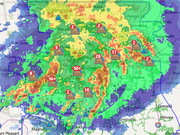
Storms moving across the state Friday morning were dropping 1 to 2 inches of rain an hour and causing flash flooding in several central and south Arkansas counties, National Weather Service meteorologist Julie Lesko said.
The storm weakened in the mid-morning hours, but the next round of heavy rainfall is expected to return before noon, she said.
"It’s been raining,but not as heavily," Lesko said. "It's going to be a very rainy period for the next 24 hours."
Forecasters said the rain will last throughout most of the afternoon, and any lull in the storm will likely be brief.
Another round of storms brewing over eastern Oklahoma will move into Arkansas overnight, according to the weather service. Those storm will bring additional precipitation until they taper off Saturday afternoon.
— Jaime Dunaway
10 A.M. UPDATE
Thousands of Arkansans were without power as of 10 a.m. Friday as hail, lightning and strong winds caused power failures across the state, according to Entergy.
At that time, Entergy reported 13,547 outages, with 8,848 in Pulaski County and another 2,124 in Saline County.
— Jaime Dunaway
9:30 A.M. UPDATE
The National Weather Service has issued a flash flood warning for several counties throughout central and southern Arkansas as thunderstorms continue to drop heavy rainfall across the state.
As more than 2 inches of rain fell in the metro area Friday morning, meteorologists placed Pulaski and Saline counties under a flash flood warning until noon.
In western Arkansas, a flash flood warning in effect until 11:45 a.m. was issued for portions of Little River, Howard and Sevier counties.
A warning is also in effect until 11 a.m. for Pike, Polk and Montgomery counties, where 3 inches of rain has fallen in the past 3 hours, according to the weather service.
— Jaime Dunaway
EARLIER:
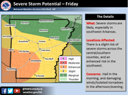
Thunderstorms capable of producing large hail and damaging winds were being tracked through central and western Arkansas Friday morning, prompting the National Weather Service to issue advisories for those areas.
A severe thunderstorm watch was in effect early Friday for more than 20 counties in parts of those regions.
The weather service said shortly before 6:30 a.m. that forecasters were tracking a thunderstorm 7 miles southeast of Mount Ida. It was said to be capable of producing 1.5-inch diameter hail and winds of up to 50 mph.
Throughout Friday, the weather service said hail and high winds will continue to be the primary threats as the storms move across the state. Tornadoes are possible as well, the agency said.
A map produced by the weather service to indicate the severity of potential storms Friday said there was an enhanced threat for the state's southwestern corner stretching to Hot Springs and Arkadelphia, while most of the central region was labeled under a slight threat.
Showers and potentially severe thunderstorms were also in the forecast for Saturday, the weather service said.
— John Moritz