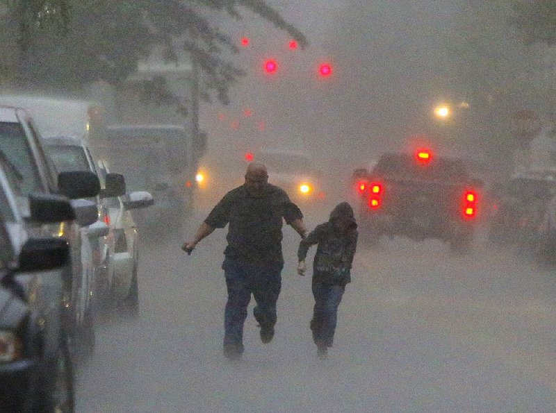
Several rounds of storms raked the state Friday, flooding roads with heavy rains and knocking down power lines, and more inclement weather is expected today, National Weather Service meteorologists said.
More than 5 inches of rain soaked the southern border of Arkansas on Friday, causing concern for overnight flash flooding as more rain was expected.
Golf ball-size hail pelted Fort Smith and Alma on Friday afternoon as a strong thunderstorm moved through west-central Arkansas, said National Weather Service meteorologist Jeff Hood of North Little Rock.
"Fort Smith has seen an abundance of hail," Hood said. "It's caused some issues for people there."
The system also dumped 1 to 2 inches of rainfall an hour during outbreaks in central Arkansas, said National Weather Service meteorologist Dennis Cavanaugh of North Little Rock.
The Weather Service issued a tornado watch -- meaning conditions were favorable for tornadoes -- for 17 southwestern Arkansas counties Friday.
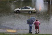
Flash flooding forced the suspension of the Rock Region Metro streetcar service in Little Rock on Friday morning and three roads in Pulaski County were barricaded because of high water, said Jarrod Johnson, a spokesman for the county. Several roads in the Little Rock metro area were briefly closed because of flash flooding.
A fallen tree blocked a county road but workers removed it quickly, Johnson said.
Saline County Office of Emergency Management Director Robert McGowen said his office measured 21/8 inches of rain in a gauge Friday morning. He said several roads had water over them.
"It's very common to have water on the roads," he said. "We had a large amount of water in a short amount of time."
McGowen spent Friday afternoon looking at a weather radar and anticipated more heavy rain.
"I'm watching for what's coming ahead," he said. "I know we will have additional road closures ahead."
The rain slowed workers setting up for the Toad Suck Daze festival in Conway, but the event wasn't postponed, Conway Chamber of Commerce President Brad Lacy said.
"We were a little behind in getting things set up," he said. "But the rain itself doesn't necessarily stop people from coming."
He said chamber officials monitored weather reports to ensure heavier storms with lightning, dangerous winds and hail were not approaching. The festival will continue over the weekend.
Entergy Arkansas reported electrical service was disrupted to 13,547 customers at the storm's peak Friday morning, with most of the disruptions in Saline, Pulaski and Faulkner counties. By Friday afternoon, power was restored to all but 4,800 customers.
The storms developed over Oklahoma early Friday as an upper level system met warm, moist air south of Arkansas. As the warm front moved from the south and bisected Arkansas, storms popped up, Hood said.
"We had the colder air in Fort Smith that was elevated and caused the hail," Hood said. "We had warmer air to the west and southwest that created additional thunderstorms."
Some areas, mostly in northern Arkansas, were expected to see a break in the rainfall this morning as the system "kicks" to the northeast, Cavanaugh said. The storms are expected to redevelop during the day before leaving the state by nightfall, he said.
At least one tornado was spotted briefly in the Sherman-Denison area of Texas just across the Red River from southern Oklahoma. There were no immediate reports of damage or injuries.
The Oklahoma Highway Patrol shut down a nearly 20-mile stretch of Interstate 35 between the cities of Purcell and Norman late Friday afternoon. I-35 connects Dallas and Oklahoma City.
Capt. Paul Timmons of the highway patrol said the main north-south interstate was shut down after reports of tornadoes and heavy hail in the area. The closure stretched from mile marker 98 near Purcell to Tecumseh Road in north Norman.
The closure came at the height of the Oklahoma City-area rush hour as a powerful storm pushed through the state, spawning reports of at least one tornado and hail the size of tennis balls in some areas.
Information for this article was contributed by The Associated Press.
State Desk on 04/30/2016