A contractor is about to break ground on a project to control flooding on a section of Interstate 30 in Little Rock that has bedeviled motorists for years, a problem that state highway officials say will only worsen as development in that part of Pulaski and Saline counties continues.
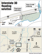
For $1.3 million, Nick Ruffin Excavating Inc. of Mayflower will build a 3-foot-high, 1,900-foot-long berm; re-channel a 100-foot section of Crooked Creek; create a nearly 19-acre flood plain; and install a pipe floodgate. But that doesn't begin to cover the entire cost of the project.
The Arkansas Highway and Transportation Department has already spent another nearly $2.5 million on the project and counting. That includes more than $1.5 million to acquire property for the flood plain and nearly $900,000 to relocate four businesses -- including $695,000 to Douglas Metals -- that once sat on the property, according to Perry Johnston, head of the agency's right-of-way division. The final bill likely will be higher as condemnation lawsuits are pending against two property owners who objected to the purchase offers from the department, he said.
Few projects have seen higher bills for relocation expenses, he said.
"I would say this would rank as a very high cost for relocation on a project," Johnston said. "This is significant to spend this kind of money to move these businesses because of the nature of the businesses."
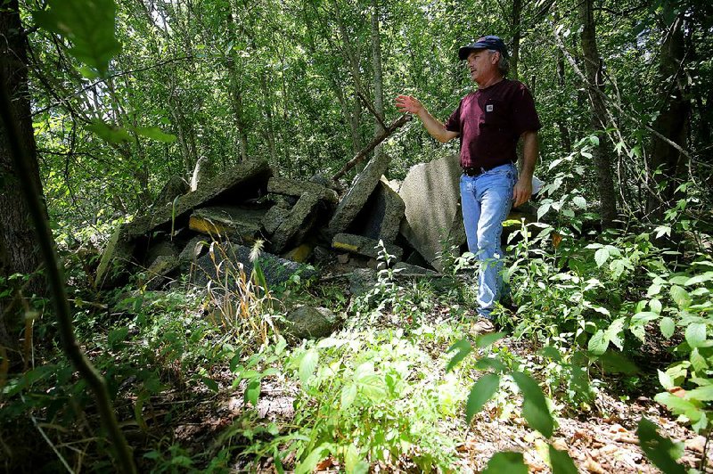
Moving Bennett Brothers Stone, for instance, involved moving more than 850 pallets of stone, as well as several individual large pieces. Johnston said the company moved the stones for the lowest competitively bid price the department received from commercial movers invited to submit bids. Bennett's relocation expenses total $102,500 so far.
But state highway officials say that the relocation expenses and the rest of the $3.8 million is money well spent when weighed against the cost to motorists every time water rises over the 2.7-mile long section in the vicinity of Crooked Creek and not far from the Saline County line. It lies about 1.7 miles west of Interstate 430 and is part of a major travel and freight corridor between Little Rock and Dallas. Nearly 90,000 vehicles travel through the section daily.
An environmental assessment of the project calculated a road-user cost of $2.4 million for an eight-hour delay during peak afternoon traffic and if 20 percent of the affected traffic could divert around the flooded section. That is what it cost motorists in lost time and added expenses when the highway is shut down.
Seven known closures since 1978 are estimated to have closed the section at least two hours each, according to the document.
The section, about a mile west of the Otter Creek exit, flooded most recently on Nov. 21, 2011, closing all six lanes for about three hours. It also was closed for more than 10 hours on Christmas Eve 2009 because of high water. A study noted the section has flooded at least one other time since it was rebuilt in 2005.
The project aims to improve the hydraulics on Crooked Creek to a 50-year flood design, which is a level of design that would ensure the interstate pavement remains dry during a 50-year flood event, which has a 2 percent chance of occurring every year. The flood-prone area now lies in a 5-year flood plain that has a 20 percent chance of flooding the interstate every year.
All interstates are supposed to be built to the specifications of 50-year flood design.
But the surrounding Crooked Creek watershed, which totals about 7,300 acres, has changed dramatically in recent decades, according to a review of aerial photography of the area between 1973 and 2009 undertaken for the environmental assessment.
"Most notably, a considerable percentage of the open space existing in 1973 was converted to urban use by 2009 indicating an increase in impermeable land surface, often associated with increased velocity and volume of runoff during rain events, which can lead to flooding," the document said.
And, say state highway officials, the project also is less expensive than any alternative.
"It's not going to fix itself," said John Fleming, head of the department's environmental division. "It only was going to get worse.
"The water is coming to you faster. Where it gets to the flood plain we're losing storage. We just can't up and change the grade of the interstate."
Creating the 18-acre flood plain required buying the property and relocating the four businesses. In addition to Bennett and Douglas, Little Rock Fence Co. and Wildman Arms and Outfitters were relocated to make way for the project.
To create the flood plain, the property will be dug out -- plans call for excavation of 76,465 cubic yards -- and then "reforested," said Trinity Smith, head of the department's road design division.
The department had proposed a more extensive channelization of the creek, but the U.S. Army Corps of Engineers, the federal agency responsible for issuing permits for the project under the Clean Water Act, preferred limiting the channelization of the creek to the vicinity of the interstate bridge.
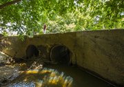
One property owner, Paul Covert, said that while he is among those who support finding a solution, he wonders why a less expensive fix wasn't looked at first. His property is on the eastbound side of the interstate and is reached via a road over Crooked Creek, which runs between the interstate and a Union Pacific Railroad line before turning to cross under the interstate.
In heavy rain events, he often sees the water build up on the west side of the bridge that carries his road over the creek because debris frequently clogs the culvert under his bridge. But the water eventually runs across the road to his property in the other direction.
A simpler fix would involve cleaning out the creek channel under the interstate as well as the ditches that run alongside the frontage roads, said Covert, who has extensive experience in construction management.
The problem, department officials say, is that the rain and flood events he describes aren't as severe as the one the department is addressing. The more severe event changes the way the water flows through the area compared with the event Covert is describing, they said.
Smith said Covert's suggestion to limit improvements to clearing the channel and ditches to see if that was enough to stem the flooding wasn't an option.
"You're kind of rolling the dice," he said. "We can't do that."
Metro on 08/08/2016