SEARCY COUNTY -- Add another gem to the crown jewels of hiking in the Ozark Mountains.
In January, a 28.5-mile extension to the Buffalo River Trail was completed, thanks to 12 years of effort by hundreds of volunteers. Beginning at Tyler Bend S̶t̶a̶t̶e̶ ̶P̶a̶r̶k̶, a U.S. National Park Service facility* and the trail's former eastern terminus, the extension shadows the river downstream to Dillard's Ferry on Arkansas 14.
For more information
Frequently intersected by gravel roads, the new Buffalo River Trail extension is convenient for day hikes and shorter out-and-back overnight trips, in addition to extended hikes.
The National Park Service plans to add access information and updated maps to its Buffalo National River park pages at nps.gov. See bit.ly/2oyZlpW
In the meantime, Michael Reed's website, compulsivehiker.com, is also a good source for maps and trail reports.
The Buffalo National River's Tyler Bend Visitor Center is at 402 N. Walnut St. in Harrison; (870) 439-2502.
-- Bob Robinson
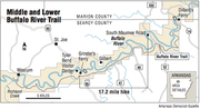
The new miles bring the trail's total length to 80 miles, but that's divided into two disconnected sections: a 37-mile western path (aka the upper section) from Boxley to Pruitt; and the newly combined middle and lower sections from Richland Creek near the Woolum ford to Arkansas 14 and Dillard's Ferry near Buffalo Point, about 43 miles.
The Buffalo River Trail project was allowed for in the 1987 National Park Service's "Trail Plan: Buffalo National River, Arkansas" (which was an update to the agency's Final Master Plan from 1975 -- written three years after Congress established the Buffalo National River). The trail plan stated in part that "trails will be constructed to provide opportunities for hiking the entire length of the river ...." But the wording that really gets credit for helping the trail happen was the provision that "as funding becomes available, or when volunteer groups come forward ...."
The park service intentions were clear and from time to time, as money was available, seasonal park service trail crews were hired. But the bulk of construction was by volunteers working under the supervision of Kenneth L. Smith of Fayetteville.
A civil engineer and former planner for the park service, Smith began working on the trail in the late 1980s. Along with Duane and Judy Woltjen, also of Fayetteville, he was exploring possible routes for the trail extension as far back as 1995.
Smith became an authority on the river and its history, writing the Buffalo River Handbook (Ozark Society, 2004) and The Buffalo River Country in the Ozarks of Arkansas (Ozark Society, 1967).
As a reward for the countless hours he contributed to making Natural State beauty more accessible, on March 13 the Arkansas Department of Parks and Tourism inducted Smith into the Arkansas Tourism Hall of Fame, along with the department's former chief photographer, Chuck Haralson.
THE PLAN
I consider the Buffalo River Trail one of the nation's most scenic hiking paths, and so I
was eager to try the newer part. Wanting to share this adventure, I posted plans for an overnight trip with the NWA Hiking Meetup Group and the Ozark Highlands Trails Association. When the number of hikers that signed up surpassed my goal in only two days, it was obvious I was not alone in the excitement of having mild weather and a new path to explore.
With information from fellow Ozark Highlands Trail Association member Michael Reed (compulsivehiker.com), Jim Liles, former deputy superintendent of the Buffalo National River, and other sources, I decided to hike the new 17.2-mile section from South Maumee Road to the Grinder's Ferry trailhead beside the U.S. 65 Buffalo River Bridge.
But as the date for our trip grew near, Mother Nature delivered a final blast of winter. On the eve of the hike, with forecasts calling for rain, freezing rain and 1 to 3 inches of snow, and a low of 22 degrees, one-by-one hikers dropped from the ranks.
On the morning of the hike, only two adventurous souls greeted me at the Grinder's Ferry trailhead: Chuck Gibson of Dermott and Scott Branyan of Rogers.
I was elated to see them, for I was beginning to worry that no one would show up, leaving me without the needed second vehicle to operate a shuttle.
THE SIGHTS
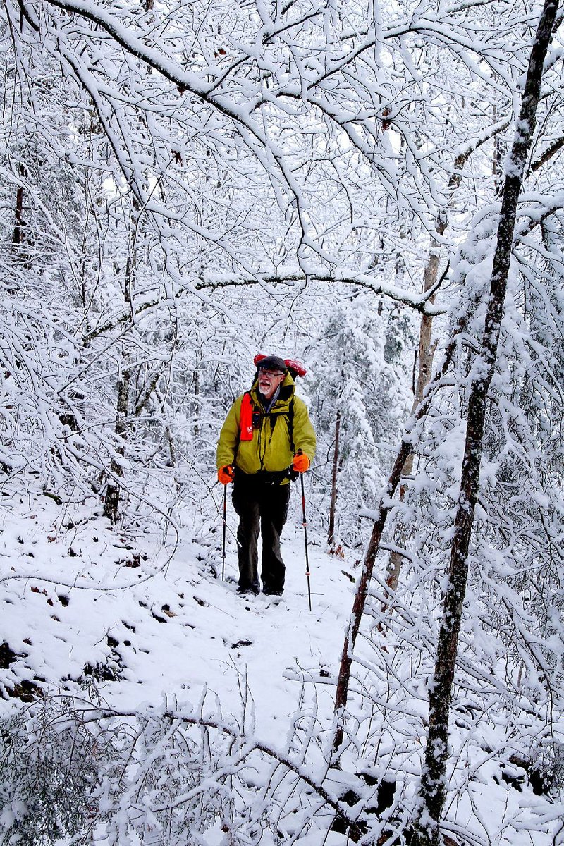
After a 20-minute drive to the trailhead on South Maumee Road, we began our walk in the woods in a light sprinkling of rain.
Within a half mile, we found ourselves standing on a rock outcropping atop a 300-foot bluff, with an unobstructed view of a sweeping, 180-degree bend in the Buffalo River.
Shortly afterward, as we cautiously worked our way along a narrow trail hand-cut into the hillside, we passed a St. Peter Sandstone cliff streaked by a small pour-off from recent rain.
During one of Smith's trail-building outings, he told me that trail construction is "both a skill and an art." I felt reassured, even in the early miles of this outing, that the skillful art I had appreciated on the original Buffalo River Trail had also been applied on the extension.
After dropping down into Hoot Owl Hollow and beginning our trek up another mountainside, the trail appeared to be routing us head-on into the face of a sheer, 20-foot rock wall. But as we reached the apparent dead-end, the trail veered right to snake into an opening just wide enough for one hiker at a time.
While making my way through this crevice I pondered how long Smith had scouted the area to find the passage hiding between the slabs of rock. Its opening was not visible beyond 10 feet away.
We rambled at a leisurely pace through more tree-filled hollows and up steep mountainsides, and the precipitation ended, encouraging wishful thoughts that perhaps this would be one of those occasions when the forecast had missed its mark.
Liles says this area lies over the Tomahawk Fault System, one of the major earthquake zones along the Buffalo River. According to him we were actually walking in a "graben," a down-thrown block between two faults.
At the mouth of Rocky Creek, the trail passed the remaining cinder-block foundation of the Bond homesite. In the following unnamed drainage, on the northwest side of the draw, there is reportedly a pre-Civil-War headstone for one A.B. Still. We were unable to find the stone, but that's a reason for a return hike.
After dropping into the next hollow, we decided to scout a place where Branyan and I could pitch our tents and Gibson could hang his hammock. We bushwhacked through thick cane and tangled driftwood to reach a pleasantly sandy beach on the banks of the Buffalo and called it home for the night.
This turned out to be a timely decision, for just as I was planting my final tent stake in the soft sand, frozen rain began bouncing off the rainfly. I crawled in and zipped up the no-see-um-mesh door. With the vestibule door open, I slipped into my down-filled sleeping bag and watched big, fluffy snowflakes powder-coat the woods.
Realizing there would be no socializing around a campfire tonight, I broke out the stove without leaving the warmth of my sleeping bag and prepared dinner under the half-open vestibule. I then feasted while watching the full moon's reflections off tiny crystals gently floating past my tent door.
DAY TWO
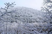
Unzipping the vestibule the next morning, I was greeted by 3 inches of snow delicately stacked on tree limbs. My world had become a black-and-white Ansel Adams nature print -- not a bad scene in which to fire up my stove for hot cocoa and breakfast.
After breaking camp, we hiked into a fairy tale setting.
Cresting the first hill, we were treated to a view that words cannot do justice. Snow-rounded mountaintops as far as the eye could see -- to our right and our left -- were crowned by clear blue skies, while at the base of the bluff, the emerald green Buffalo appeared nearly fluorescent, framed by the pure white snow.
Under the bright morning sun, our winter wonderland trek lasted barely an hour before the branches began to shed their snowy blanket.
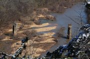
As the trail followed the banks of Brush Creek we came across two concrete piers standing upright in the drainage. These are the remains of the bridge over which the Missouri & North Arkansas Railroad traveled in 1910 on its scheduled route from the Mississippi River to southern Missouri.
I followed the rail bed north for about 100 yards to view a massive set of concrete piers evenly spaced across the Buffalo River bed. They towered some 60 feet above the river, and it was difficult to imagine that in December 1982 flood waters covered the tops of the piers.
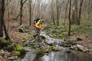
Following a cold, wet crossing on Brush Creek, we climbed another ridge to reach Horton Cemetery. We dropped our packs and explored until we found the single legible headstone of Thomas Treat, 1848-1923.
Our trail then followed an older path flanked by moss-covered cairns that marked the way for generations of visitors to the cemetery.
UNCERTAIN CROSSING
After crossing Zack Ridge Road the trail dropped down another hillside to Bear Creek. This is the Buffalo River's fourth largest tributary, accounting for 6 percent of the watershed.
When planning your trip, be sure to check water levels at the U.S. Geological Survey website (waterdata.usgs.gov) for Bear Creek at Silver Hill gauge station 07056515. As the Buffalo River Trail extension is new, my sources didn't indicate what level would be safe for crossing Bear Creek. Based on my experience, I would not plan a crossing with said gauge anywhere near 2 feet.
When in doubt, drop your shuttle vehicle at the Zack Ridge Road trailhead. Please report your own experiences with the crossing to the National Park Service to help it advise future hikers.
ONCE UPON A TIME
Once across Bear Creek, the trail climbed a steep mountainside for a view of the Gilbert community on the opposite bank of the river.
Gilbert originated in 1902 as a construction camp for the Missouri and North Arkansas Railroad and became a shipping point for cotton, timber and zinc ore. At one time it even operated a saloon, but that floated away with the flood of 1915.
During its remaining miles, the Buffalo River Trail offers more expansive views from bluff tops before dropping down and through a final hollow.
As the trail follows an overgrown roadbed it passes the remains of a relatively modern homestead. With its remaining concrete foundation and earthen embankments, it was built to withstand the frequent flooding that accompanied life on the Buffalo.
This may have been the home of one of the descendants of Samuel Grinder, who began ferrying people across the Buffalo in 1853. Josh and George Grinder continued the operation into the 1870s. Ferry service ended in 1929 with the construction of the first U.S. 65 bridge.
Those who have hiked parts of the original Buffalo River Trail and enjoyed the unspoiled beauty of the first National River will be pleased with this extension of that experience.
Note: The extension fills yet another gap in the proposed Trans-Ozark Trail, a 700-mile footpath envisioned as stretching from Lake Fort Smith State Park to St. Louis. Given existing trails within Arkansas such as the Ozark Highlands Trail and its Sylamore section, Buffalo River Trail, Norfork Trail and David's Trail, only selected short gaps remain to be filled for a route that reaches the state line. At that point it could join the mostly complete Ozark Trail, which extends all the way to St. Louis.
It will happen.
ActiveStyle on 04/03/2017
*CORRECTION: The Buffalo National River Visitor Center at Tyler Bend is a U.S. National Park Service facility. A previous version of this article incorrectly described the park.