A storm system with heavy rain and strong winds pushed through the state Wednesday, knocking out power to thousands, flooding streets and downing trees.
Emergency officials reported no injuries, but rescue teams conducted at least six swift-water rescues in Washington County on Wednesday morning, and a team located one canoeist trapped by rapidly rising waters on the Buffalo National River and were still searching for another as of 6 p.m.
At least 11,000 Entergy of Arkansas customers were without electricity Wednesday afternoon with a majority of those customers in Pope County. Another 3,000 customers of the Carroll County Electric Cooperative in Booneville were without electrical service, said Rob Roedel, a spokesman for the Electric Cooperatives of Arkansas.
The National Weather Service issued tornado warnings for Arkansas, Conway, Faulkner, Johnson, Perry, Pope, Prairie, Van Buren and Yell counties during the day, but there were no reports of twisters touching down.
A storm spotter reported seeing rotating winds over Arkansas Tech University in Russellville on Wednesday morning, the National Weather Service said.
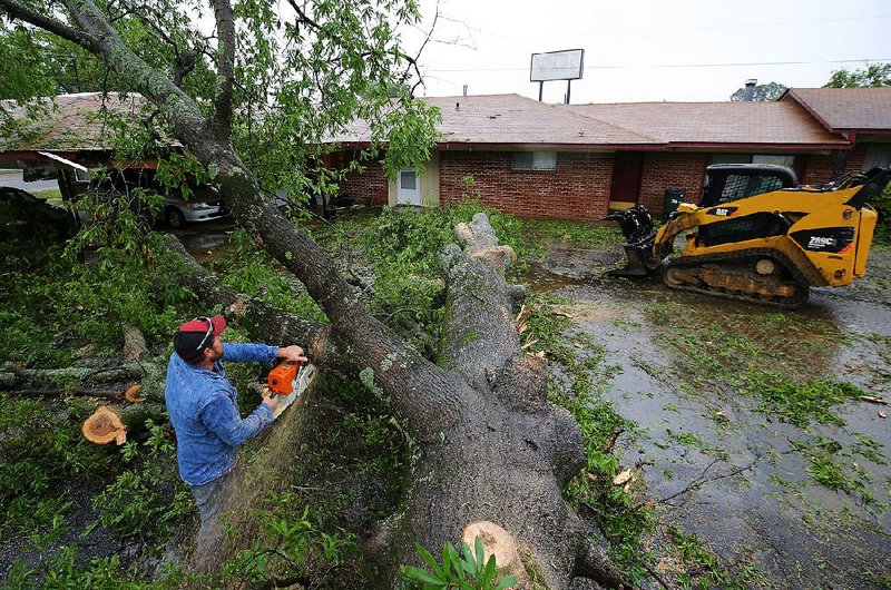
In Yell County, straight-line winds tore off the roof and blew down the front of a vacant building used for storage in Plainview, said Jeff Gilkey, the Yell County Office of Emergency Management coordinator.


"There are a lot trees down, and we've had reports of trees on houses," Gilkey said. "There's going to be a lot of cleanup."
He said the brunt of the storm was in southern Yell County.
Neighboring Logan County saw tennis-ball-sized hail in the Ratcliff community west of Paris.
"We had a lot of customers telling us about it," said Matilda Lofkahr, an employee of the N Mart on West Walnut Street in Ratcliff. "I was inside the store and didn't see it, but the storm that came through was bad.
"Some were concerned about damage to their houses," she said. "They hadn't seen hail that size in a long while."
Two people apparently were swept away by rapid water when their canoes capsized, Buffalo National River park spokesman Caven Clark said in a news release.
Four men in four canoes decided to tackle the floodwaters Wednesday morning above Kyles Landing in Newton County, according to the news release. Two of the men managed to navigate the distance safely, but the canoes of two others overturned.
Rescuers found one of the men trapped on an upstream island near Kyles Landing about 3 p.m. Wednesday. The search for the second man continued until about 6 p.m. and will resume this morning, according to a news release.
The Buffalo National River will close Tyler Bend campground Friday, and park officials have begun shutting off utilities at campsites in anticipation of a "significant flood event," Clark said.
The Steel Creek concert featuring National Park Radio, rescheduled to Saturday after last week's inclement weather, has been postponed because of the weather.
Clark asked park visitors to avoid water crossings at Rush, Webb Branch, Erbie and other areas because they will likely become unusable as the water rises.
"A possible break between storms on Thursday [and Saturday] should not lull visitors into hazardous situations," Clark said in a news release. "Float trips are not recommended as the Buffalo River is already running at high stages and will very likely be in flood stage soon."
The Buffalo River gauge at St. Joe indicated that the river was at 8 feet at 7 a.m. Wednesday and was expected to rise to 22 feet this morning. Flood stage there is 27 feet.
Washington County Office of Emergency Management director Rick Johnson said teams conducted six swift-water rescues Wednesday morning as 2-3 inches of rain fell on the area in less than two hours.
A lot of streets were closed because of flash flooding, he said.
"It came hard and really fast," he said of the rainfall. "The ground was already saturated so it didn't soak in. What was hitting the ground was running."
The storm moved across the state, entering central and northern Arkansas by midafternoon.
In Lawrence County in northern Arkansas, water began encroaching on Arkansas 25 between Black Rock and Powhatan. The Black River is expected to crest at 23 feet in Black Rock. Flood stage there is 14 feet.
Floodwaters covered Black Rock's baseball field on the northeastern edge of town by midmorning, Mayor Bonnie Ragsdale said.
"If we get all the predicted rain, we'll probably see water over Arkansas 25," she said. "It's already out of the banks.
"A lot of people don't realize that even if we get only a small amount of rain in Black Rock, all the water comes from the Spring, the Eleven Point and the Current rivers down to Black Rock," Ragsdale said.
Meteorologist Michael Brown of the National Weather Service in North Little Rock said the storm system left the state late Wednesday evening. He said several areas across the state reported 2-3 inches of rainfall during the day.
A second front is expected to enter the state Friday afternoon and mix with Gulf Coast moisture already over Arkansas, Brown said. Forecasters are concerned that the system will be more volatile than Wednesday's.
"It won't be as widespread as this one," Brown said, referring to Wednesday's storms. "But it has a good potential for tornadoes."
The National Weather Service predicts up to 6 inches of rain for central and northern Arkansas on Saturday, which would cause flash flooding.
State Desk on 04/27/2017
RELATED ARTICLE
http://www.arkansas…">Northwest Arkansas inundated, floods sweep away homeless camp