Rescue teams continued their search Thursday for a missing man on the Buffalo National River, and emergency officials assessed the damage from Wednesday's storms that raked much of the state with high winds, large hail and torrential rains.
Now, National Weather Service meteorologists are watching a new storm system that is expected to dump as much as 8 inches or more of rain on the northern half of Arkansas tonight and Saturday.
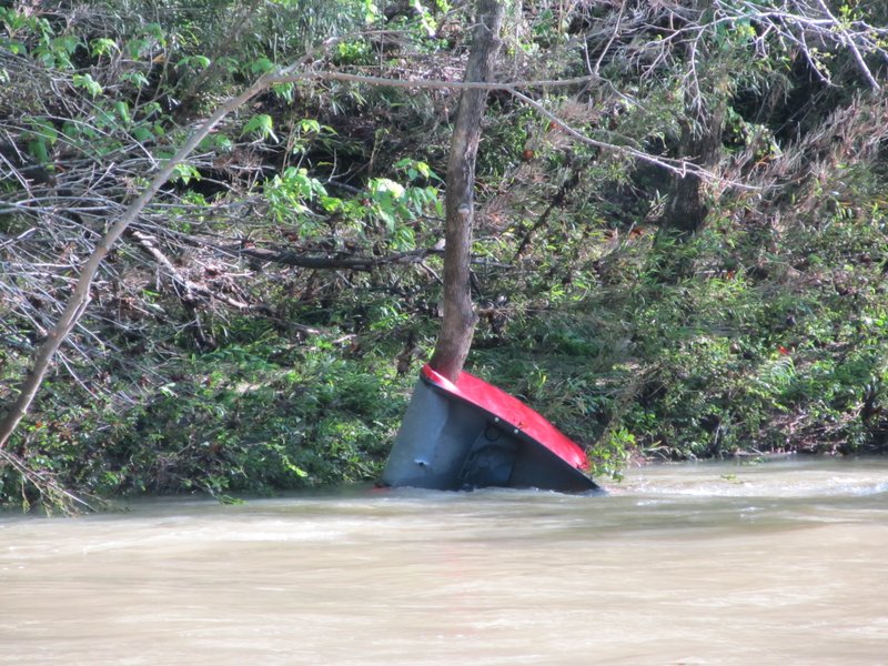
"We are already saturated," said Newton County Deputy Glenn Wheeler, who is overseeing the search for a man who fell from an overturned canoe into the flooded Buffalo National River on Wednesday morning.
"Any more rain will cause a major problem," he said Thursday afternoon. "We are doing as much of a push today as we can."
Buffalo National Park spokesman Caven Clark said four men entered the river in canoes at Kyles Landing in Newton County. Two made it out safely, but two of the other canoes overturned.
Clark said rescue teams found one canoeist on a small island upstream from Kyles Landing about 3 p.m. Wednesday.
"Apart from being cold, he was in good condition," Clark said.
Wheeler said teams searched the river and along the riverbank for the missing man Thursday. Deputies also used tracking dogs.
"We are still in search-and-rescue mode," he said.
The Buffalo National River near St. Joe rose to 23.4 feet early Thursday morning after 2-3 inches of rain fell on the area. The river dropped to 12.9 feet by early evening.
In Washington County, road crews closed Blue Springs Road near Goshen after about 30 feet of roadway washed away, said Rick Johnson, the county's Office of Emergency Management coordinator.
Several other roads were closed until workers could remove fallen trees, gravel and other debris left on the roadways from flash flooding.
Wednesday's storms knocked out power to more than 14,000 customers as a cold front crossed the state and merged with warm, Gulf Coast moisture. The National Weather Service issued tornado warnings for at least 10 Arkansas counties during the day, but no twisters were confirmed.
A National Weather Service survey team from North Little Rock inspected damage near Brinkley on Thursday and determined that it was caused by straight-line winds of up to 75 mph, said meteorologist Tabitha Clarke of the service's office in North Little Rock.
Forecasters are calling for more severe storms for the state today and Saturday as a warm front is expected to move north across Arkansas.
The Storm Prediction Center in Norman, Okla., said the northern half of Arkansas is at an "enhanced" risk for severe weather today, with high chances of damaging winds and hail. The formation of tornadoes is also a possibility, Clarke said.
"We'll see storms Friday attached to the front as it comes through," she said. "There will be super-cells that can form tornadoes."
Storms are forecast to "train," or stall and re-form, over isolated areas and dump heavy amounts of rain Saturday.
Clarke compared Saturday's weather with that of a May 31, 2013, storm that deluged western Arkansas with up to 10 inches of rain and caused flash flooding. Scott County Sheriff Cody Carpenter was killed while trying to rescue people caught in rapidly rising water.
"It's going to be a mixed bag of weather this weekend," Clarke said.
The northern three-fourths of the state is under flash flood watches that were issued Thursday by the National Weather Service.
The state has seen plenty of rainfall during the past 30 days. The U.S. Drought Monitor, an organization based at the University of Nebraska at Lincoln that issues weekly drought reports for the nation, said Arkansas' drought situation has lessened greatly.
On Thursday, the monitor indicated that 44.5 percent of the state was in some form of drought. A month ago, on March 21, 86 percent of Arkansas was considered to be in drought.
The National Weather Service calls for 6-8 inches of rain, mostly across the Ozark Mountains in Northwest Arkansas. Some weather-forecasting models have indicated that up to 12 inches of rain could fall locally near Yell County from today through Sunday.
"There will be heavy rain along a band from Fayetteville to Fort Smith," said meteorologist Mark Plate of the National Weather Service in Tulsa. "Flooding will be the biggest issue."
"Our swift-water rescue teams are getting ready," Yell County Office of Emergency Management coordinator Jeff Gilkey said. "The sheriff's office is preparing for this, too."
Emergency officials spent Thursday posting weather advisories on social media, Gilkey said
"If we get that much rain, our roads and bridges will be devastated," he said. "We're setting up for a unique situation. This is going to be tough. We want to make sure everyone is safe."
State Desk on 04/28/2017