4:10 P.M. UPDATE:
Portions of eastern Arkansas are forecast to receive the highest rainfall totals from Tropical Storm Harvey, though uncertainty remains about where the system will enter the state and how much precipitation will fall.
Between 1 to 5 inches from Little Rock eastward to the Mississippi River is now expected by Friday afternoon, said Thomas Jones, a meteorologist with the National Weather Service’s North Little Rock office. The western half of the state is likely to see minimal precipitation.
Harvey continued to shift eastward Tuesday afternoon, reducing the amount of rainfall forecast for portions of the state’s east, including Brinkley and Pine Bluff.
[LATEST ON HARVEY: Find all storm updates here]
Forecasters had said earlier in the day that up to 8 inches could fall in portions of eastern and central Arkansas.
“There’s going to be a really drastic line,” Jones said of where the bulk of precipitation will fall in Arkansas.
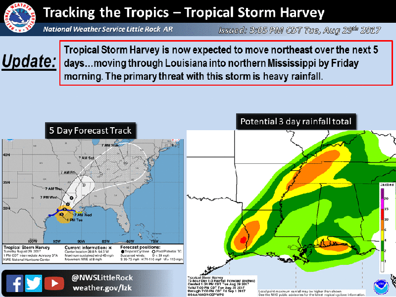
The outer bands of Harvey will begin to affect south Arkansas by late Tuesday or early Wednesday, according to the weather service.
The latest track has the system drifting north and east though central Arkansas and into the state’s eastern half before leaving by Friday evening.
Those planning to attend the Arkansas game against Florida A&M on Thursday night can expect to see at least light rain as the season opener unfolds at War Memorial Stadium in Little Rock, Jones said.
Isolated tornadoes and thunderstorms may be spawned from the system, meteorologists said.
Despite the latest outlook, Jones stressed that forecasting Harvey’s impact is “still pretty fluid” and noted that the system has little consistency.
Read Wednesday's Arkansas Democrat-Gazette for latest information on Harvey.
EARLIER STORY:
Tropical Storm Harvey will careen inland into Arkansas in the coming days, bringing with it threats of heavy rain, flash floods and isolated tornadoes, forecasters predicted Tuesday.
Hurricane Harvey walloped the coast of southern Texas over the weekend and continues to drop buckets of rain in the area after the system transitioned into a tropical storm. It’s forecast to make a second landfall on the upper Texas coast early Wednesday before slowly drifting north and east, according to a Tuesday morning statement from the National Weather Service of Little Rock.
Most of Harvey is predicted to pass into southeast Arkansas on Thursday night and curve into northern Mississippi on Friday morning, forecasters said early Tuesday.
Before the entire system enters Arkansas, the outer bands of Harvey will reach the state and bring rain, starting Wednesday morning, the statement said. The heaviest rainfall is predicted for Thursday and Friday.
Rainfall totaling 4 to 8 inches is possible in the eastern and central portion of the state along Harvey’s direct path whereas the northwest corner of Arkansas can expect less than an inch, officials said.
As for Little Rock, the forecast shows anywhere from 3 to 5 inches of rainfall with the possibility of thunder, though that’s subject to change. Meteorologist Michael Brown said the Little Rock office thinks Harvey is moving further east than originally predicted.
If it does move to the east, Little Rock and the surrounding area could see lower precipitation, around 1 to 2 inches, Brown said. He cautioned that forecasters will know more when the tropical storm starts migrating into the state.
Heavy rain can bring flash flooding, the National Weather Service warned in its release. White, Black, Ouachita and Saline basins as well as the lower Arkansas south of Pine Bluff are all at risk of river flooding.
Isolated tornadoes could also be spawned from the tropical storm, though they tend to be “weak and short-lived" but still dangerous, the release said. They generally move south to north or southeast to northwest, the release said.
The greatest tornado threat comes Wednesday afternoon and evening as well as Thursday afternoon and night across southeast Arkansas below Pine Bluff, the release said.