11:17 P.M. UPDATE
The National Weather Service has extended a flash flood warning for several parts of central Arkansas.
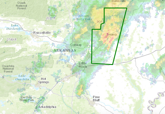
The warning, issued for northwestern Prairie County, northern Lonoke County and White County, extends until 1:15 a.m.
Forecasters say storms brought by remnants of Tropical Depression Cindy brought several inches of rain to the area in hours, and flash flooding has already been reported.
A flash flood watch, which extends until Friday afternoon, was issued for these counties: Grant, Lonoke, Prairie, Monroe, Woodruff, Arkansas, Bradley, Cleveland, Desha, Drew, Jefferson, Lincoln, Calhoun, Dallas and Ouachita.
— Jillian Kremer
7:36 P.M. UPDATE
A tornado warning that had been in effect for part of central Arkansas has been canceled, but a flash flood warning has been issued for several counties.
The tornado warning, which had covered part of White County, was expired about 10 minutes early. No tornado warnings were active in the state as of 7:35 p.m.
The flash flood warning, however, covered southwestern Independence County, northwestern Prairie County, southwestern Jackson County, northern Lonoke County and White County. It runs through 10:30 p.m.
The warning noted that additional heavy rainfall is expected in those areas, which have already seen up to 3 inches of rain.
— Gavin Lesnick
7:14 P.M. UPDATE
A tornado warning issued for part of central Arkansas has been extended until 7:45 p.m.
The weather service set the warning for southeastern White County after a severe thunderstorm capable of producing a twister was spotted at 7:12 p.m.
The storm was located 7 miles southeast of McRae, about 12 miles south of Searcy, and was moving north at 20 mph.
The area under the warning includes the cities of Searcy, Bald Knob and Judsonia as well as part of U.S. Highway 67, between mile markers 36 and 51.
A warning issued for northwestern Prairie County expired at 7:19 p.m.
— Jillian Kremer
7:01 P.M. UPDATE
A tornado warning remains in effect over parts of Arkansas as storms connected to Tropical Depression Cindy move further inland.
The National Weather Service extended a warning that covers parts of Prairie and White counties until 7:15 p.m. Forecasters said a tornado-capable storm was located near Thurman, about 11 miles west of Des Arc, and was moving north at 25 mph at 7:01 p.m.
The warned area includes the cities of McCrae and Higginson.
Warninga issued for parts of Jefferson and Grant counties and part of Lonoke County was allowed to expire around 7 p.m.
— Jillian Kremer
6:15 P.M. UPDATE
A tornado warning has been issued for Lonoke, Prairie and White counties in central Arkansas.
The warning is in effect until 6:45 p.m. for the counties, according to the National Weather Service.
At around 6:20 p.m., a storm capable of producing a tornado was near Lonoke, moving north at 25 mph.
Cities included in the tornado-warned area include Lonoke, Ward, Beebe and Carlisle.
A tornado warning previously in effect for a portion of Lonoke County expired at 6:15 p.m.
— Brandon Riddle
6 P.M. UPDATE:
A tornado warning has been issued for Lonoke County, in effect until 6:15 p.m., according to the National Weather Service.
The agency’s North Little Rock office said the tornado-warned storm was near Parkers Corner, or about 10 miles southeast of Lonoke around 5:50 p.m.
It was moving northwest at 20 mph, officials said.
The weather service said tree damage is likely. Damage will also be possible to roofs, windows and vehicles.
— Brandon Riddle
1:25 P.M. UPDATE:
Forecasters issued a tornado watch for two counties in southeast Arkansas as well as parts of Alabama, Louisiana and Mississippi through Thursday night as thunderstorms spawned from Tropical Depression Cindy push inland.
Both Ashley and Chicot counties were placed on tornado watch by the National Weather Service through 10 p.m. The watch was issued at 1:05 p.m. from the storm prediction center in Norman, Okla.
Hail up to a marble in size, isolated gusts up to 70 mph and a few tornados are all possible during that time, forecasters said.
The eastern border of Louisiana as well as the southern two-thirds of Mississippi and the western-central portion of Alabama were placed on a tornado watch as well. The entire area encompasses almost 7.3 million people, 2,183 schools and 246 hospitals, according to the weather service.
Read Friday's Arkansas Democrat-Gazette for full details.
— Emma Pettit
EARLIER:
Forecasters predict thunderstorms spawned from former Tropical Storm Cindy will move into southern Arkansas Thursday night and begin to spread, bringing heavy rain south and east of Little Rock into Friday.
Heavy rain and thunderstorms are expected to arrive in southern Arkansas late Thursday, according to a forecast released by the National Weather Service of Little Rock. Those storms will then spread across the southern half of the state with the southeast region predicted to get the most rain.
A flash flood watch was issued through Friday afternoon for the southern and eastern half of the state. The watch is for all counties east of a diagonal line that stretches from Lafayette County to Lonoke County to Randolph and Lawrence counties. Little Rock sits just west of that line.
The capital city and surrounding area can expect between 2 to 3 inches of rainfall from late Thursday into early Saturday, meteorologist Chris Buonanno said. As the system gets closer, rain will fall at a steady rate, he said. The National Weather Service will be monitoring areas with the heaviest precipitation.
A flood warning was also issued Wednesday for the portion of the White River at Clarendon in Monroe County. The warning continues through Saturday.
The southeast corner of the state from El Dorado to south of Pine Bluff through Helena West-Helena is under a slight risk for severe weather and could see severe storms as early as Thursday afternoon and evening. A weak tornado or two is also possible, meteorologists said.
The central portion of the state is under a marginal risk of severe storms on Thursday, forecasters said.
The heaviest rainfall is predicted for overnight Thursday into early Friday morning.
Rain will continue through Friday, with 2 to 5 inches possible in southern and eastern counties, the forecast said. Due to the high levels of moisture in the atmosphere, more than 5 inches of precipitation could fall in isolated spots, meteorologists predicted.
The system is expected to exit the state toward the Tennessee Valley on Friday afternoon as a cold front pushes into Arkansas from the Great Plains.
The system is forecast to then sweep across the vast majority of Tennessee and the lower half of Kentucky, reaching the western tip of Virginia by 1 a.m. Saturday.
Cindy, which was previously a tropical storm, has since been downgraded to a depression.
— Emma Pettit