6:10 P.M. UPDATE:
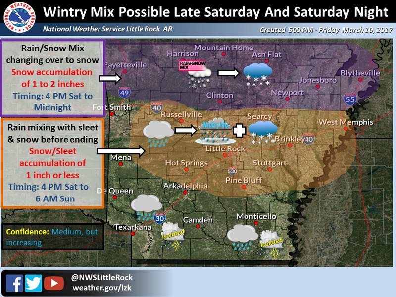
Up to 2 inches of snow is now forecast this weekend for north Arkansas, with lesser amounts possible in the state's central region, according to the National Weather Service.
In its latest outlook Friday evening, the agency's North Little Rock office said "a bout of winter weather is becoming more likely" during the afternoon and evening hours Saturday.
"Winter is not over just yet," the weather service said on Twitter.
Rain is expected to switch over to a wintry mix of sleet and snow around 9 p.m. Saturday before changing over to only snow across the northern third of Arkansas around midnight, forecasters said.
Between 1 to 2 inches of sleet and snow will be possible across the state's north. Areas of central Arkansas, including Little Rock, could see up to 1 inch of the precipitation.
The weather service said the accumulation will mainly fall on grassy surfaces and elevated roads.
"Significant travel impacts are not anticipated at this time but bridges and other elevated roadways may become slick especially across the northern three rows of counties," according to the outlook.
Read Saturday's Arkansas Democrat-Gazette for full details.
EARLIER:
Freezing temperatures in northern Arkansas are expected to crystallize rain into snow Saturday afternoon and bring a light dusting to the region, according to the National Weather Service’s latest forecast.
A cold front sweeping through the state will bring a chill after temperatures expected Friday in the 50s and 60s, said Heather Cross, a meteorologist with the Little Rock weather service office.
A cluster of northern counties can expect temperatures to drop to the low-to-mid 30s Friday night and then continue to fall to the low-to-mid 20s on Saturday, Cross said. The swath of Arkansas expecting those cold temperatures stretches east from the southern corner of Carroll County along the northern border.
Precipitation in the air Saturday morning will lead to rainfall in those areas, Cross said. Around noon, that rainfall will freeze into snowfall — a transition that will be “pretty quick,” she said. The best chance of seeing flakes is around 6 p.m., Cross said, and the dustings will continue into early Sunday morning.
A pocket of land from west of Blytheville to east of Mountain Home and from Jonesboro up to the northern border can expect about a half inch of snow, according to Friday morning’s forecast. Areas on the outskirts of that pocket from Blytheville to Newport to Harrison will see between a tenth and three-tenths of an inch, the forecast said.
Another light round of snow in northern Arkansas is expected overnight on Sunday, though meteorologists are “not expecting accumulations to be very much at all,” Cross said.
Central Arkansas will likely just experience rain this weekend, Cross said, though there could be “a flurry or two.” Temperatures will be in the high 30s to low 40s Friday night and hover around freezing on Saturday, she said.
The National Weather Service also issued a freeze warning Friday night in these counties: Boone, Newton, Marion, Searcy, Stone, Baxter, Izard, Fulton and Sharp.
Arkansans in those areas should cover their plants or try to protect their crops, Cross said.