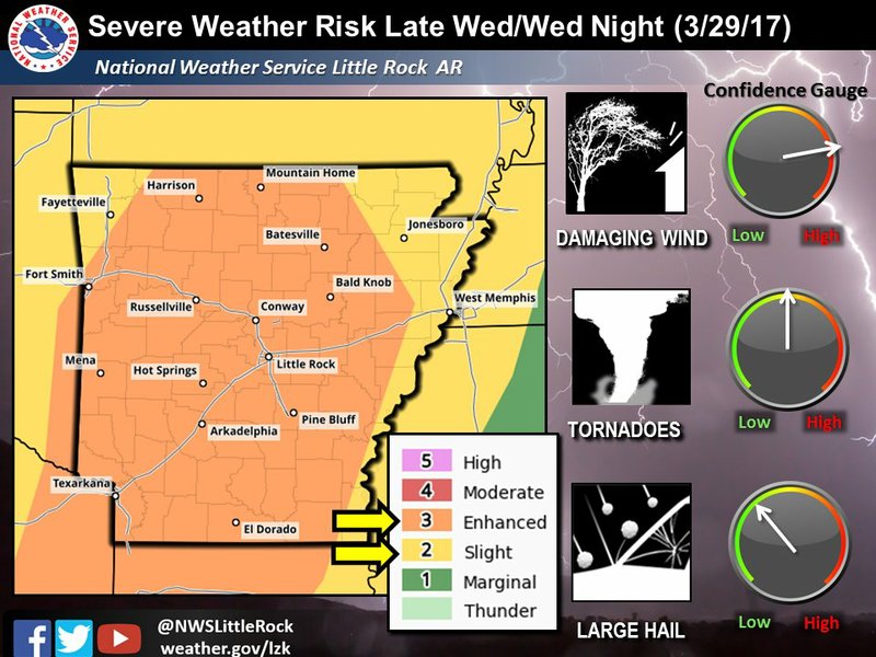
A line of thunderstorms predicted to sweep across Arkansas on Wednesday evening brings the risk for damaging winds, tornadoes and hail, weather officials say.
The National Weather Service of Little Rock has placed most of Arkansas under an enhanced risk for severe weather Wednesday evening into early Thursday morning, according to the Tuesday morning forecast. That was an upgrade for a large part of the state that had previously been under a slight risk and the agency said parts of Arkansas may be further escalated later Tuesday to a moderate risk for severe weather, which is the second-highest category.
A cold front will reach western Arkansas as early as Wednesday afternoon and the rest of the state Wednesday evening, meteorologist Sean Clarke said. A “big line of storms” will form out in front of the cold air and sweep across the state, eventually crossing the Mississippi River around 6 a.m. Thursday, he said.
A few tornadoes may be "embedded" in the line of storms, and the system and will be similar to the severe weather that descended on Arkansas Friday night, Clarke said. At least six tornadoes have been confirmed from that storm system.
Gusts blowing west to east Wednesday into Thursday could reach 60 mph and do some extensive damage, Clarke said. Those "straight line" winds can be just as destructive as tornadoes, he noted.
High temperatures across the state will hover in the low 80s Wednesday and drop to the upper 60s around sunset, Clarke added.
In addition to the severe storms, meteorologists say there is a chance for damaging hail up to 2 inches in diameter and heavy rainfall. Most of the state will see 1 to 2 inches and higher amounts are possible in parts of western Arkansas, Clarke said.
Strong thunderstorms are able to produce a lot of rain in a very short period of time, so the water doesn’t have time to run off and can pool in roadways, Clarke said. Western Arkansas has the highest chance of localized flash flooding, though people should be ready to seek higher ground anywhere there’s significant rainfall, Clarke said.
The very northwest corner of the state near Fayetteville and the northeast corner stretching down the eastern border are at lesser risk for severe weather, though isolated and intense storms are still possible there, forecasters said.
Read Wednesday's Arkansas Democrat-Gazette for full details.