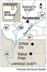
POCAHONTAS -- The roiling Black River spilled over a levee system east of Pocahontas on Tuesday afternoon, and officials feared imminent collapses of the earthen structure will send a "wall of water" cascading toward neighboring Lawrence County.
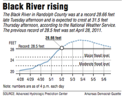
The river surpassed its previous high mark of 28.47 feet at 2 p.m. Tuesday at the Randolph County town, and it continued to rise during the day. At 7 p.m., the river level was 29.1 feet.
The National Weather Service expects the Black River to crest in Pocahontas at 31.5 feet Thursday afternoon.
Gov. Asa Hutchinson flew over Randolph and Sharp counties Tuesday, inspecting damage left by last weekend's storms that killed at least seven people across the state. The governor declared a state of emergency and said he will soon ask for federal disaster aid.
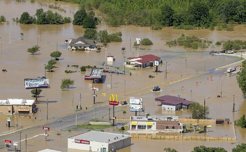
"This is the most extensive flooding in an urban area that I've ever seen as governor," said Hutchinson, who held a brief news conference at a Pocahontas Fire Department station after his tour. "As we flew over Pocahontas, we couldn't even see the flow of the river. It's totally flooded all over."
City officials ordered on Monday the evacuation of eastern Pocahontas, including about 150 homes, an assisted-living apartment complex and dozens of businesses. Much of the Robel Addition had been vacated by Tuesday, but a few people opted to remain in their homes rather than evacuate.
"The levee could breach any minute," Pocahontas Mayor Kary Story told residents who chose to stay. "You need to get out of there while you still can."
County Judge David Jansen of Randolph County said a mile of the levee near the confluence of the Black and Current rivers was topped by rising water Tuesday afternoon.
"We're going to have breaches in the levee," Jansen said. "This is a historical crest. The levees weren't designed for overtopping. When they go, we're going to have a wall of water pouring out."
Arkansas Highway and Transportation Department officials closed U.S. 67 just south of the Black River bridge Tuesday morning when water covered the roadway. By midafternoon, U.S. 67 was closed at the border for Randolph and Lawrence counties.
On Monday, officials also closed a section of U.S. 62 east of Pocahontas toward Corning.
"We've secluded Biggers and Reyno from us," Randolph County Sheriff Gary Tribble said.
"We can't get to that side of the county."
Tribble said one deputy lives in that area and will patrol there. Clay County Sheriff Terry Miller said he also would send deputies to eastern Randolph County to assist Tribble if needed.
Tribble moved 12 prisoners from his county jail in Pocahontas to the Craighead County jail in Jonesboro on Monday in anticipation of the flood.
On Tuesday, he moved all personnel from the sheriff's office, which sits on the southern banks of the Black River, to a command center in north Pocahontas.
"I never had to leave my building before," the sheriff said. "I had to do it this time. The river is coming up quickly and it'll stay here for a while."
Jansen said the river had been rising at a rate of 2 to 3 inches an hour. At 10 a.m. Tuesday, the county judge stood atop the levee and saw the river had reached within 6 inches of flowing over it.
"We realized it was time to get out," he said.
Jansen said he saw several deer and other animals swimming in search of higher ground. On Monday, a lone deer galloped down U.S. 67 by Pocahontas Municipal Airport while cars, slowed by evacuating traffic and construction, lined the road for about 3 miles.
"All kinds of critters are out there trying to save their lives," Jansen said. "It's really sad."
Hutchinson said he flew over Pocahontas and Ash Flat on Tuesday morning and later drove through flooded areas.
"We saw the extraordinary risk the citizens of northeast Arkansas are placed in because of flooding," he said. "We saw houses under water and multiple businesses with water in them."
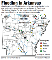
The National Weather Service is forecasting more rain for tonight and Thursday, said meteorologist Heather Cross of the National Weather Service in North Little Rock.
Most of the state will get some rainfall. Western Arkansas will receive between 1 and 2 inches and the eastern quarter of the state, including Pocahontas, will have between 1 and 1.5 inches.
"The rain is going to hit where we don't need it," Cross said.
Hydrologist Tabitha Clarke of the weather service in North Little Rock said the Black River is expected to crest at 31.5 feet at 1 p.m. Thursday, although it may be less if levees break and water pours out before reaching the river gauge in Pocahontas.
Downstream at Black Rock, the Black River crested at 30 feet Monday and is gradually receding.
Although Pocahontas and Black Rock are only about 25 miles apart, the river levels vary greatly between them.
The Black River at Black Rock receives water from the Spring and Eleven Point rivers, which both crested Sunday and receded quickly.
The river at Pocahontas is fed by the Current River, which set records for high levels in Doniphan and Van Buren, Mo., earlier this week when as much as 10 inches of rain deluged the area.
"Missouri kept getting whacked by rain," Clarke said. "There's no way to capture all that rain up there. It's all coming down [to Pocahontas]."
Hutchinson said he will ask officials to study why the Black River has seen three major floods -- referred to as "100-year floods," meaning the chance for such a flood is once every 100 years -- in nine years.
East Pocahontas was flooded in 2008 and 2011 when heavy rains fell in Missouri. Levees broke in both previous floods, sending water down the Running Water Ditch south of Pocahontas and toward Portia in Lawrence County.
"There's speculation for why there have been these floods," Hutchinson said. "The Black River hasn't been dredged, so water doesn't move as fast. The levees contain the water more. There is a lot of speculation.
"We need the [U.S. Army] Corps of Engineers to work with levee boards and do a comprehensive review of this."
Barbara Clark, a retired high school teacher who lives in Portia, watched the Black River flood fields behind her house Tuesday and wondered if water escaping from the levee would reach her home like it did in 2011.
"The weather radio came on with a flood alert this morning," she said. "It startled me. I don't think it will be as bad as 2011, but you never really know. This has been a strange year for weather already."
Several homes near Portia Bay had water lapping against them Tuesday, and officials closed one road that ran adjacent to the bay because of flooding.
In Black Rock, Roy Waggoner picked up debris from his yard left by a tributary of the Black River. He lives in a mobile home high enough on an embankment that water would not reach it, but his neighbor below had water up to the front door of her home.
The river, which crested at 30 feet at noon Monday, dropped to 28.7 feet by 7 p.m. Tuesday.
"I'm not nervous. I live up on a hill," said Waggoner, who has lived in his home on West Main Street for 20 years. "But there's always a first for everything. There's always a chance for the water to get up higher than it's ever been."
State Desk on 05/03/2017
RELATED ARTICLES
http://www.arkansas…">Eureka Springs police ID woman who died in tubing accident http://www.arkansas…">High water wipes out swinging footbridge