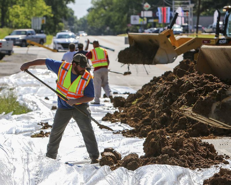
Floodwaters from the overflowing Black River continued to recede in Lawrence and Randolph counties Friday, and highway officials reopened a section of U.S. 63 near Portia.
RELATED ARTICLE
http://www.arkansas…">Greenbrier rushes to aid flood victims


The route had been closed after breaks in a levee system in Pocahontas sent a rush of water over the highway earlier this week.
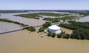
But residents farther south in Des Arc and Clarendon are bracing for rising waters of their own as the "flood wave" makes its way down the Black River and into the White River.
Heavy storms Saturday and Sunday dumped 4 to 6 inches of rain across much of northern Arkansas, causing flash flooding, disrupting power and spawning tornadoes. Seven people died because of the storms, and officials in western and northwestern Arkansas are searching for two people swept away in rapid waters.
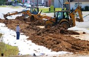
In preparation for flooding from the White River, workers built a 5-foot-high earthen levee near Arkansas 323 in northern Des Arc on Friday to protect houses in low-lying areas in the Prairie County town.
Davis Bell, a spokesman for the Prairie County Office of Emergency Management, said emergency officials learned how to better deal with flooding after the rising White River encroached on the town in 2011.
"People are ready to make quick decisions this time," Bell said. "We've seen flooding before."
The National Weather Service expects the White River to crest at 36.5 feet in Des Arc on Wednesday. Flood stage there is 24 feet.
If the river reaches the expected height, it will be the third-highest recorded in its history, only bested by the 39.4-foot mark set on May 7, 2011, and the 37.3-foot reading measured on Feb. 2, 1949.
Once the White River crests in Des Arc, it will remain at that level for several days before beginning a very slow decline, said meteorologist Dennis Cavanaugh of the National Weather Service in North Little Rock.
Because the Mississippi River is rising, he said, drainage from the Arkansas River into the Mississippi River will be slow. The White River runs into the A̶r̶k̶a̶n̶s̶a̶s̶ ̶R̶i̶v̶e̶r̶ Mississippi River*.
For area officials, it creates concern.
"Will the levee hold with all that pressure for so long?" Bell asked. "I hate to use a cliche, but God only knows."
Emergency officials have already evacuated residents from homes in some areas prone to flooding.
"We've already seen 12 inches of rain over the last seven days," Bell said. "There is water everywhere."
More than 10 inches of rain fell in southern Missouri last weekend, sending torrents of rainwater runoff into the Current River in the Missouri towns of Van Buren and Doniphan. Both of those towns saw record levels on the Current River, and all that water eventually made its way in a "flood wave," or slowly moving mass of water, down to its confluence with the Black River, Cavanaugh said.
The Black River in Pocahontas reached a record-high level of 28.95 feet Tuesday evening before nine sections of the levee that runs along the southern edge of the river and protects homes and businesses in eastern Pocahontas collapsed.
Water rushed southward toward Portia in Lawrence County, crossing U.S. 67 near the Lawrence and Randolph county border and then over U.S. 63 east of Portia.
John Thomison, county judge of Lawrence County, suggested that residents of the town of 437 evacuate Wednesday as a precaution, but water never reached Portia.
"We're seeing the levels drop today," Thomison said Friday.
Near Portia, where officials from the Arkansas Highway and Transportation Department opened two lanes of U.S. 63 on Friday afternoon, crews cleared debris off the roadway. The remaining lanes should reopen soon.
Thomison said he can't assess damage because some county roads remain underwater.
"Once you get past Walnut Ridge, it's all water," Thomison said.
Nearly 950,000 acres of cropland have been flooded and losses could reach $64.5 million, according to the University of Arkansas System's Division of Agriculture. Rice, the row crop most planted at the time the rains and floods began, was especially hit hard.
The Agriculture Division's estimates are based on the cost of seed and herbicides already applied, as well as equipment and labor. They do not include damage to poultry facilities in northeast Arkansas and farm structures such as grain bins.
Jarrod Hardke, a UA rice agronomist, estimated 156,000 acres of rice lost, 83,200 acres of soybeans damaged, 47,900 acres of corn flooded and 9,300 acres of cotton destroyed.
David Jansen, county judge of Randolph County, was able to go to his home east of Pocahontas on Thursday evening for the first time since flooding began Monday. Highway officials had closed U.S. 67 between Corning and Pocahontas when the Current River overflowed and covered the road.
He said some residents were allowed back into an east Pocahontas subdivision where officials had ordered an evacuation Monday. About 50 homes were destroyed by floodwaters and another 100 were damaged.
Jansen said deputies spent Friday rescuing people who were sightseeing on county roads.
"They think they can drive out there now that the water is going down," Jansen said. "But they don't know what they are seeing. Some of our roads are washed out."
He said 40 people remained in the county's former nursing home, which has been converted into a shelter.
The receding water allowed Rick Walker, owner of R&M RV Park on U.S. 67 just south of Pocahontas, access to his business.
Six people who live there fled the park as waters began rising Tuesday. About a foot of water inundated Walker's park at the flood's peak.
"I knew it was going to happen," Walker said of the flooding. "I was here in 2011."
The Black River levee also broke during flooding in April 2011, sending a similar wave of water across thousands of acres of farm fields.
Walker said his campers weren't damaged, but flooding had blocked access to the park until the water receded.
"There's debris in the road now," he said. "And I saw a lot of fish lying on the highway."
Farther south, Jackson County Sheriff David Lucas said residents of some towns along the White River were beginning to leave as the river began to rise.
Deputies spent much of Friday rescuing motorists who drove around highway barricades to see flooding and then became trapped in deep water.
"It never ceases to amaze me," he said.
Arkansas 69, 14, 37 and 224 in Jackson County are closed because of high water.
Monroe County Office of Emergency Management coordinator Philip Norman said he is making residents aware of the impending flooding, but he has not ordered any evacuations along the White River.
The river is expected to crest at Clarendon at 35.5 feet next Friday. Flood stage there is 26 feet.
"Folks have been through a lot of floods here," he said. "They know how to make preparations."
Officials brought in large pumps to help remove water in low-lying areas of Clarendon, and some residents have placed sandbags around their homes in anticipation of the rising water.
"Some houses will be affected," Norman said. "They always are."
Information for this article was contributed by Stephen Steed of the Arkansas Democrat-Gazette.
*CORRECTION: The White River empties into the Mississippi River in southeastern Arkansas. The last 10 miles of the river serves as the final segment of the McClellan-Kerr Arkansas River Navigation System. The Arkansas River meets the Mississippi River about 8 miles south of the confluence of the White and Mississippi rivers. A previous version of this article incorrectly stated the White River’s path.
A Section on 05/06/2017