
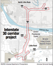
Interstate 30 through downtown Little Rock and North Little Rock will be built as a 10-lane corridor rather than eight lanes, according to Arkansas Department of Transportation plans for the $631.7 million project.
The agency on Wednesday released its latest analysis from the data amassed so far for the project at a meeting of the Metroplan board of directors.
Ben Browning, a top Transportation Department official, told the board that computer traffic modeling conducted on all of the project's alternatives showed that the eight-lane alternatives didn't eliminate bottlenecks in the corridor as initially anticipated.
The department had eliminated the eight-lane alternatives earlier in its planning process, which began in 2014, but after receiving criticism for it, the Federal Highway Administration told the agency to continue to include those alternatives.
Browning insisted the latest decision was driven by information, not opinion.
"The highway department doesn't have a preference," he said. "The data determines the preferences."
A Federal Highway Administration representative at the meeting, Amy Heflin, said her agency will review the information the department used to reach its decision before deciding what alternative will be used.
Officials familiar with the design say the 10-lane plan features four lanes that will be more like city streets, with ramps to lower speeds, narrower lanes, traffic signals and other features to allow traffic moving on or off I-30 to safely interact with pedestrians and other noninterstate traffic.
"It's not going to be 10 lanes of pure interstate," Metroplan Executive Director Tab Townsell said at the monthly board meeting for the long-range transportation agency for central Arkansas.
The 10-lane alternative has been recently referred to as six main lanes with four collector-distributor lanes. The latter are separated by a wall from the main lanes, have slower speeds and allow traffic traveling between Little Rock and North Little Rock to cross the bridge without entering the main interstate lanes.
In response to changes sought by Little Rock, the department has refined the 10-lane design.
"The reason why they are particularly calling it a six-lane CD is ... although it is still part of the interstate system, those [collector-distributor] lanes become city streets in function," Townsell said. "They will still be part of the interstate system, but they become and function like city streets.
"So what looks like an interstate pretty much through that section is going to be roughly the same size as what is there today."
Still to be determined is how traffic will get into and out of downtown Little Rock at the interstate. The department has designed two options: the split-diamond interchange and the single-point urban interchange.
A split-diamond interchange is a variation of the diamond interchange, which separates intersecting roads at congested urban and suburban intersections. The single-point interchange is used to improve traffic capacity and operations while requiring less right of way than a traditional diamond interchange.
The Metroplan board voted Wednesday on a resolution endorsing the split-diamond, which is what is preferred by Little Rock Mayor Mark Stodola because of the 18 acres of park space that will be created by eliminating the interchange at Cantrell Road.
Department officials said that choice also would allow drivers several options to travel into or out of downtown compared with what exists now at the Cantrell Road interchange or even an improved version of it, which is a single-point urban interchange.
The split-diamond has been reconfigured. It no longer will funnel traffic down Sixth Street. It also will avoid funneling traffic on and off at Ninth Street. Sixth Street is lined with historic homes, and Ninth Street is part of the MacArthur Park Historic District. Instead, it will distribute traffic throughout the downtown street grid system.
"You're going to have multiple ways to access downtown Little Rock," Browning said.
"One of the things they were particularly concerned with was the split-diamond's likelihood of getting through the environmental [review] process," Townsell said. "Because if it did negatively impact in a significant way the historic district, the federal rules require not mitigation, but avoidance. So you immediately eliminate the split-diamond and go to the [single-point urban interchange].
"That's not what the cities and counties prefer."
Only one of the 21 voting board members present voted against the resolution.
Wanda Crawford, acting executive director of Rock Region Metro, the Pulaski County transit agency, said she opposes any action that isn't in keeping with the vision of the region set out in Metroplan's long-range transportation plan, called Imagine Central Arkansas.
"The Metroplan board of directors originally voted for the Imagine Central Arkansas plan with unanimous approval following two years of planning and outreach," she said. "A central tenet of that plan was to maintain a balanced approach to mobility within our region by limiting freeways and expressways to six lanes and meet additional travel demand through transportation alternatives."
By widening the interstate, Crawford said, it "creates even more disparity among transportation options, tipping our region to invest more heavily in cars and highways rather than sustainable choices, including public transportation."
She also expressed concern over the latest changes to the split-diamond interchange alternative, which she said would increase traffic on East Capitol Avenue. Her agency's main bus station, Rock Cities Travel Center, is between East Capitol Avenue and East Fourth Street, where 436 buses enter the bus bays and are used by 3,000 passengers each weekday.
Coupled with nearby private development that includes apartments and a bowling alley, the new design will add to what already is a "congested situation," Crawford said.
"The area is already generating much more pedestrian traffic," she said. "We are very concerned about impacts on safety and traffic congestion in a key corridor."
Patricia Blick, executive director of the Quapaw Quarter Association, which promotes preservation in downtown Little Rock, said some of the changes are welcome, but she worries about the impact of the project on historic parts of downtown.
"We are pleased with some of the modifications we have seen, but obviously we have very serious concerns," she said. "The mission of the QQA is preservation of Little Rock historic places. So far, our initial concerns are that the split-diamond was pushing too much traffic into the MacArthur Historic District and also immediately adjacent to a National Historic Landmark, the Tower Building at MacArthur Park.
"We have not had an opportunity to evaluate this modification, so we look forward to continuing conversations."
Whatever interchange design is incorporated into the project, Blick added, still leaves worries about the pressure the project will put on Interstate 630, "which obviously was devastating to historic resources when it was constructed many years ago."
Passage of the resolution, officials say, should help ease approval of a fix involving the project that is threatening to hold up $232 million in road projects in central Arkansas. At issue is the description of the project.
The region's transportation improvement plan document describes it as "operational improvements," but the state Transportation Department says it needs to be described the same way as the region's long-range transportation planning document, which calls the work "capacity improvements."
The state Transportation Department said federal regulations don't permit it to fund highway projects in the region unless the wording in the documents match. But Metroplan needs approval for the new language from the three local officials whose jurisdictions are affected by the project, including Stodola.
"That they've tweaked the split-diamond to make it more palatable seemingly, right now, gives them more comfort," Townsell said. "Maybe they will move toward signing the letter authorizing Metroplan to proceed with consideration of the TIP amendment, and the impasse will go away."
"The resolution passed today goes a long way toward giving me greater comfort on the alternative to be selected," Stodola said. "I've heard the disagreement. Making this amendment to the [transportation improvement plan] is consistent with what the Metroplan board did previously."
Metro on 11/30/2017