NEW ORLEANS -- Hurricane Nate crashed ashore Saturday evening at the mouth of the Mississippi River, threatening homes and businesses in low-lying areas along the Louisiana coast, and steamed toward the Mississippi coast, where it was expected to make another landfall.
The fast-moving storm was expected to pass to the east of New Orleans, sparing the city its most ferocious winds and storm surge. And its 20 mph speed decreased the likelihood of prolonged rain that would tax the city's weakened drainage pump system.
The city famous for all-night partying had been placed under a curfew, effective at 7 p.m., but the mayor lifted it when it appeared that the storm would pass by and cause little problems for the city. Still, the streets were not nearly as crowded as they typically are on a Saturday night, and Mayor Mitch Landrieu asked people to shelter in place.
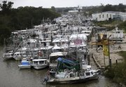
Cities along the Mississippi coast, such as Gulfport and Biloxi, were on high alert. Some beachfront hotels and casinos were evacuated. Rain began falling on the region during the day Saturday, and forecasters called for 3-6 inches, with as much as 10 inches in some isolated places.
[HURRICANE TRACKER: Follow Maria’s projected path]
Nate weakened slightly and was a Category 1 storm with maximum winds of 85 mph when it made landfall in a sparsely populated area of Plaquemines Parish in Louisiana. Earlier, forecasters had said the storm could strengthen to a Category 2, but that seemed less likely as the night wore on.
Storm surge threatened low-lying communities in southeast Louisiana and eastward to the Alabama fishing village of Bayou la Batre.
Southeast of New Orleans, storm-weary people in the Braithwaite community of the vulnerable Plaquemines Parish prepared to evacuate Saturday afternoon ahead of the storm.
"If it floods again, this will be it. I can't live on promises," said Larry Bertron as he and his wife packed to leave the home they rebuilt after Hurricane Isaac in 2012. They also lost their home to Hurricane Katrina in 2005.
Governors in Louisiana, Mississippi and Alabama -- mostly spared so far during this year's active hurricane season -- declared states of emergency as Nate neared.
"This is the worst hurricane that has impacted Mississippi since Hurricane Katrina," Mississippi Emergency Management Director Lee Smithson warned Saturday. "Everyone needs to understand that, that this is a significantly dangerous situation."
Officials rescued five people from two sailboats in choppy waters before the storm made landfall. One 41-foot sailboat lost its engine in Lake Pontchartrain, and the two sailors aboard were rescued. Another boat hit rocks in the Mississippi Sound, and three people had to be pulled from the water.
Louisiana Gov. John Bel Edwards urged residents to make their storm preparations quickly and stressed that Nate could produce a storm surge of up to 11 feet in some coastal areas.
"It's going to hit and move through our area at a relatively fast rate, limiting the amount of time it's going to drop rain," Edwards said. "But this is a very dangerous storm nonetheless."
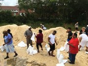
Streets in low-lying areas of Louisiana were already flooded Saturday. Places outside of levee protections were under mandatory evacuation orders, and shelters opened there.
Landrieu warned residents and the 40,000 visitors to stay indoors.
"This storm should not bring us anything we are not prepared to handle, presuming we all cooperate," he said Saturday morning from a new hurricane-fortified fire station in the rural eastern portion of the city.
Landrieu urged people to avoid the shores of Lake Pontchartrain, which sometimes draw daredevil surfers after a storm. He earlier ordered an evacuation from three neighborhoods that are outside the levees that protect the rest of the city.
"This is one of the most vulnerable areas of the city," he told those residents under glowering skies. "You are at high risk if you are on this side of the flood wall ... and you've got an acute risk tonight," he warned.
But Nancy Bell, president of the Venetian Isles homeowners association, said about half of the people in 275 homes in that area were preparing to stay and ride out the hurricane.
"In Katrina, we had an 18-foot storm surge here, and water didn't get into my main living area," said the 25-year resident who elevated her house after Katrina, put up hurricane shutters and has a generator with extra fuel. "From what they're saying, this is likely to be a hit-and-run storm. It would take you longer to get away," she said.
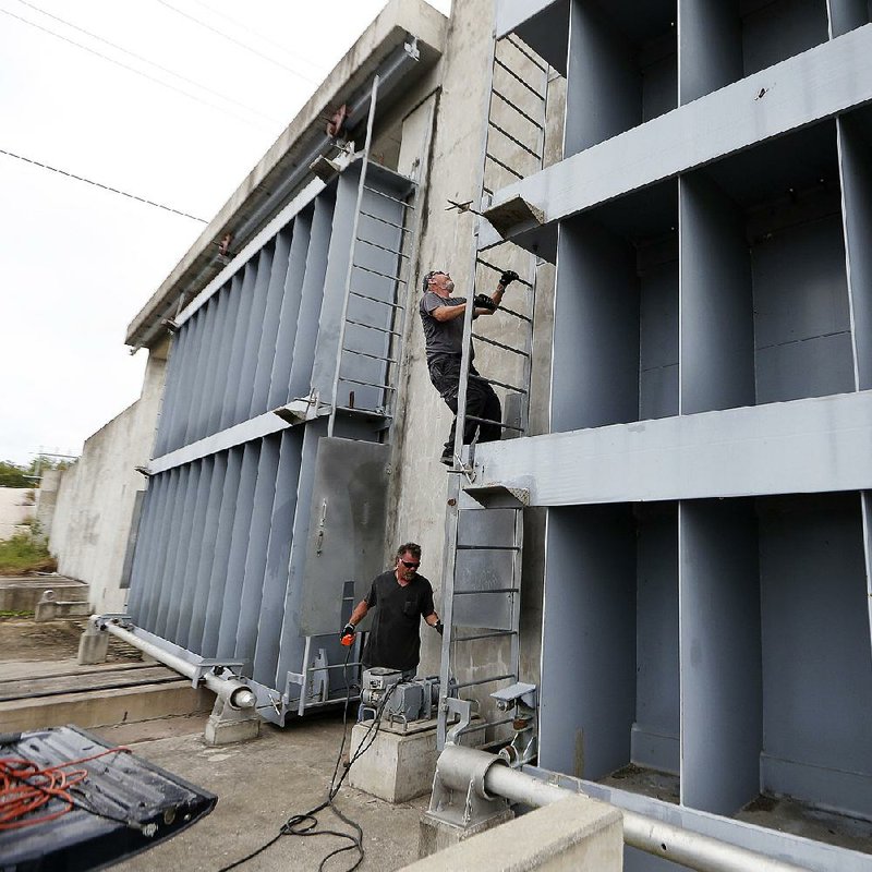
Some people worried about New Orleans' pumping system, which had problems during a heavy thunderstorm on Aug. 5. The deluge exposed system weaknesses -- including the failure of some pumps and power-generating turbines -- and caused homes and businesses to flood.
Landrieu said that although 11 of the city's 120 drainage pumps are not operating, there are enough to keep most of the city dry. Officials have been in contact with every nursing home in New Orleans, he said, to ensure that they all have generators and fuel. The city has also made a sweep of all known homeless encampments.
The U.S. Coast Guard suspended port operations Saturday from New Orleans to Mobile. Edwards said in a midday news conference that he had spoken with President Donald Trump, who promised him that federal resources were at the ready.
Trump had signed a pre-storm emergency declaration to empower the Federal Emergency Management Agency to coordinate relief efforts. The Louisiana National Guard, meanwhile, mobilized 1,300 troops and positioned high-water vehicles, boats and other emergency vehicles throughout the area.
Despite the governor's warning to hunker down by 3 p.m., traffic on Interstate 10 through New Orleans was busy throughout the afternoon as rain from the outer bands of the hurricane swept into the city.
On Alabama's Dauphin Island, water washed over the road Saturday on the island's low-lying west end, said Mayor Jeff Collier. The storm was expected to produce storm surges of 7 to 11 feet near the Alabama-Mississippi state line.
The window for preparing "is quickly closing," Alabama Emergency Management Agency Director Brian Hastings warned Saturday afternoon.
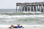
Also Saturday afternoon, Florida Gov. Rick Scott urged residents in evacuation zones in Escambia and Santa Rosa counties on the Panhandle to heed the warnings and go to shelters. He said shelters will be available to people who have nowhere else to go.
"Hurricane Nate is expected to bring life-threatening storm surges, strong winds and tornadoes that could reach across the Panhandle," Scott said. The county evacuations affect roughly 100,000 residents in the western Panhandle.
The Pensacola International Airport announced that it would close at 6 p.m. Saturday and remain closed today. However, the Louis Armstrong New Orleans International Airport was open Saturday.
"We are urging customers to check with their specific airlines to see whether their flights have been canceled because there have been some of those," spokesman Michelle Wilcut said.
Nate is expected to quickly weaken as it cuts a path from the Southeast to Northeast, which is expected to feel its effects early this week.
Nate has been blamed for at least 21 deaths in Central America as it swept through the Gulf of Mexico last week. It is the ninth hurricane to form in the Atlantic this season, which is the highest number since the 2012 season that featured Hurricane Sandy.
Waterside sections of New Orleans, outside the city's levee system, were under an evacuation order, affecting about 2,000 people. But not everyone was leaving.
Gabriel Black of the Venetian Isles community sent his wife, a friend and three dogs to a hotel in the city. Black stayed behind because an 81-year-old neighbor refused to leave.
"I know it sounds insane, but he has bad legs, and he doesn't have anybody who can get to him," Black said.
Blondy Moore and Iram Chedikah struggled to carry a newly purchased generator into their home in New Orleans' Gentilly neighborhood Saturday afternoon.
"I've been through Katrina, and all this flooded," Moore said, indicating her street. "It was a major inconvenience."
Chedikah, a pastor, said prayer is also high on their list of preparations. "Prayer is number one," he said. "I've been praying for the city of New Orleans. For the Sewage and Water Board. And for our political leaders, that they will make the right decisions to keep New Orleans safe."
Information for this article was contributed by Janet McConnaughey, Melinda Deslatte, Jeff Amy, Kim Chandler, Kevin McGill and Gerald Herbert of The Associated Press; and by Carmen Sisson, Ashley Cusick, Patricia Sullivan, Greg Porter and Ian Livingston of The Washington Post.
A Section on 10/08/2017