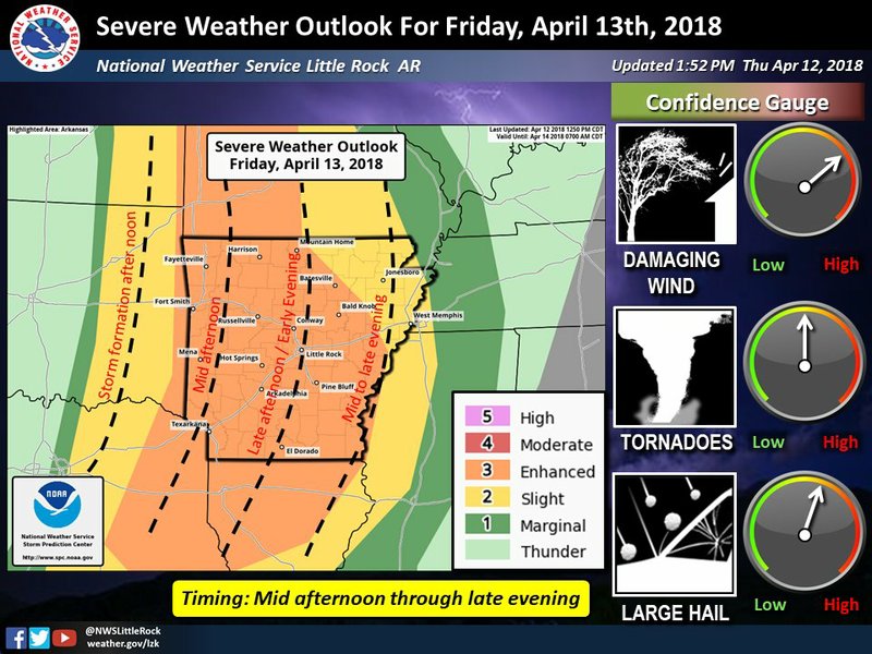
The National Weather Service has expanded the enhanced risk for severe storms Friday to include all but Arkansas' northeast.
The risk means multiple, more persistent severe storms are possible in cities like Little Rock, Conway, Fayetteville, Fort Smith, Harrison, Texarkana, El Dorado, Pine Bluff and Hot Springs.
Northeast Arkansas, meanwhile, faces a a slight risk for scattered, short-lived storms.
The primary concerns will be large hail, damaging winds and a few tornadoes, Lance Pyle of the weather service’s North Little Rock office said.
"Our confidence is increasing in the chances for tornadoes with this system," the agency said Thursday afternoon on Twitter.
Forecasters in Shreveport said “potentially strong” tornadoes will be possible in southwest Arkansas.
The latest forecast calls for the rain to enter western Arkansas around 4 p.m. and push into central Arkansas between 7 p.m. and 10 p.m. Friday.
Click here for larger versions
Photos by the National Weather Service
Photos by the National Weather Service
Pyle advised that Arkansas residents need to “prepare for severe weather now,” including having a safe place to go if a tornado warning is issued.
Heavy rainfall is possible across parts of the state, especially across southeast Arkansas, Pyle said. In that region, up to 5 inches is forecast.
“Be prepared for high water if you live in a flood prone area,” the latest outlook reads.
As the rainfall departs, cooler air will be in place in Arkansas. In the state’s northwest, temperatures are set to fall near freezing early Sunday and below freezing Monday morning.