5:30 P.M. UPDATE:
Icy roads were already causing crashes on one Arkansas interstate Tuesday evening.
Two sections of an ice-patched Interstate 49 have been shut down due to crashes, the Arkansas Department of Transportation said.
A multi-vehicle accident took place near mile marker 72 in Springdale, closing all northbound lanes of a 0.1-mile section, the agency reported about 5:15 p.m. That portion was opened about 30 minutes later.
Minutes later, the department said another one-tenth mile section of northbound I-49 near the 67 exit in Fayetteville was closed due to "hazardous road conditions" and multiple vehicle accidents. It reopened shortly after 6:45 p.m.
A section of U.S. 62 stretching from the Baxter County line to Arkansas 87 in Fulton County was also partly covered by ice as of Tuesday afternoon, the agency's live conditions map showed.
— Rachel Herzog
4:20 P.M. UPDATE:
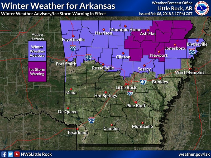
An ice storm warning has been issued for 12 counties in northern Arkansas, according to the National Weather Service.
The warning is in effect until 6 a.m. Wednesday for Randolph, Clay, Lawrence, Greene, Craighead, Dunklin, Cleburne, Independence, Izard, Jackson, Sharp and Stone counties, the weather service said.
More than one quarter of an inch of ice — enough to bring down trees and power lines — is expected in the northeastern part of the state. The heaviest icing is expected from Mountain View and Heber Springs northeast to Pocahontas and Walnut Ridge. Freezing rain and sleet are expected to total one-tenth of an inch or less.
Click here for larger versions
Photos by National Weather Service
Photos by National Weather Service
The heaviest accumulations are predicted between 6 p.m. and midnight, the service said. The storm will end after midnight, leaving slick roads, especially in the northeast part of the state, though warming temperatures Wednesday will improve travel conditions.
Entergy’s standard resources in the state’s north are prepared, and equipment has been checked in advance of Tuesday’s freezing rain, company spokeswoman Kerri Case said.
“We are not under the impression that we would need more resources,” she said earlier Tuesday.
As for the southern and southeast part of the state, isolated strong storms with hailstones greater than 1 inch in diameter are possible overnight.
— Rachel Herzog
2:05 P.M. UPDATE:
An ice storm warning has been issued for six counties in northern Arkansas, according to the National Weather Service, but Entergy Arkansas says it doesn't anticipate deploying additional resources to handle the effects of the freezing rain.
A warning is in effect until 6 a.m. Wednesday for Cleburne, Independence, Izard, Jackson, Sharp and Stone counties.
The weather service’s North Little Rock office says total ice accumulations could reach one quarter of an inch to three-tenths of an inch in areas of eastern and north-central Arkansas.
Power outages and tree damage are likely because of the ice, and travel is expected to be “nearly impossible,” according to the latest advisory.
A winter weather advisory is also in effect until 6 a.m. Wednesday for counties in the northern third of Arkansas.
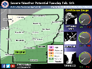
Forecasters have dialed back the risk for severe weather Tuesday evening and into early Wednesday. A marginal risk for storms to turn severe exists for southern and southeast Arkansas, with large hail as the primary threat.
Entergy’s standard resources in the state’s north are prepared, and equipment has been checked in advance of Tuesday’s freezing rain, company spokeswoman Kerri Case said.
“We are not under the impression that we would need more resources,” she said.
The Arkansas Department of Transportation said via social media that crews don’t pretreat roads in advance of freezing rain events, noting that salt trucks will be on the road Tuesday night as the temperature drops.
“At just before freezing, the salt begins to fly as we make brine in real-time,” the agency said.
— Brandon Riddle
EARLIER STORY:
A front pushing through Arkansas on Tuesday brings the possibility of ice accumulation to certain parts of the state and severe weather to others.
A winter weather advisory will be in effect from 3 p.m. Tuesday until 6 a.m. Wednesday for roughly the northern third of the state, according to the National Weather Service in North Little Rock.
Northern and north-central Arkansas — including Conway, Russellville, Fayetteville, Jonesboro and Harrison — could see up to two-tenths of hazardous ice accumulation, meteorologists said.
Forecasters said “confidence remains low” regarding how much freezing rain could fall.
Charles Dalton, a meteorologist in North Little Rock, said confidence is fairly high, however, in the areas that will see ice.
Still, the advisory could extend to a row of counties further south and into the Ouachita region of west-central Arkansas later in the day, Dalton said.
“Travel is not advised unless absolutely necessary,” according to the weather service, which noted that motorists need to be prepared for slippery roads and limited visibilities.
Along with the chance for wintry precipitation, a marginal risk for severe weather is forecast for roughly the southern third of Arkansas.
Areas under that risk include Texarkana, Pine Bluff and El Dorado.
The main threat will be hail, and the best chances for severe weather will be during the evening and overnight hours, according to the weather service.
High temperatures Tuesday are expected to reach the mid- to upper 30s in northern and central Arkansas. The state's south will see highs in the 40s and low 50s.
— Brandon Riddle