Finding a new site for aviation navigation equipment that prevents the Little Rock port from making more of its property available for industrial development will cost up to $100,000 and take a year to 18 months.
The Little Rock Port Authority board of directors on Wednesday approved a resolution allowing the authority to enter into an agreement with the Federal Aviation Administration to study relocating the navigation aid and use Garver, a North Little Rock engineering firm, to conduct the study.
The authority is setting aside $50,000 for Garver to identify two or three potential sites. Another $50,000 has been designated for leasing a portable navigation aid to test whether any of the sites are suitable. Any money not spent under the agreement will be returned to the port.
"It's not an ideal situation," Bryan Day, the port authority's executive director, told the board. "We wish it didn't exist. But if we don't address it, it restricts our ability to grow and evolve. The best land for manufacturing is on that side of the port."
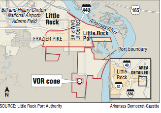
The navigation aid is part of a nationwide network of VHF omnidirectional radio range stations -- often identified by the acronym VORs. The station in question is in a remote area between the port and David D. Terry Lock and Dam and southeast of Bill and Hillary Clinton National Airport/Adams Field.
The omnidirectional technology was developed after World War II and widely installed in the 1950s, becoming the major navigation system for aircraft in the 1960s.
About 1,000 stations with varying capabilities dot the United States, creating a series of omnidirectional radio station highways in the sky for pilots to fly cross country from station to station if their aircraft is equipped to use the navigation system.
In recent years, the technology has been supplanted by newer navigation systems that use satellites.
The FAA, citing the $110 million annual cost to maintain the omnidirectional navigation system, is phasing out about 30 percent of the stations over the next few years. Enough will be kept, the agency said, to have a robust enough system in place as a backup to satellite navigation.
The Little Rock station will remain under the FAA plan.
"For all practical purposes, it can't be eliminated," Day said. "However, it can be moved."
The location of the station limits the development that can occur in the acres surrounding it to minimize the potential for interfering with the station sending and receiving signals from civilian and military aircraft that still use the system to navigate.
In the past two years, the port has acquired two parcels on either side of the station totaling 464 acres at a cost of $4 million.
Day said the board weighed the risks of acquiring the land while the station remained. The port has $10 million set aside from a three-eighths percent sales tax city voters approved in 2011.
"We knew that when people started seeing that the port and the city had money, prices were going to go up," he said. "We were able to negotiate what we think are very fair deals on these pieces.
"It's high and dry and close to the river and served by rail so it's the best property out here."
And if the station isn't moved? "We would just turn around and put it back on the market, back for farming or other purposes," Day said. "But we believe the cone will be removed and we now have land tied up that we got at fair prices and to invest in the future."
The FAA owns another 55 acres in the immediate vicinity of the station. If the station is moved, the port can apply to obtain the FAA property at no charge, Day said.
It will take up to six months to find the potential sites, which must be within 200 miles of the airport.
"They will look for things like soil conditions, access, fiber optics, electricity, hills, mountains, buildings, trees," Day said. "Ideally, if anyone has a 10,000-acre soybean farm and willing to sell us a half of an acre in the middle of it, that would be perfect."
The port then will lease a portable station, most likely from Ohio University in Athens, Ohio, to test the sites. Day said that could cost another $50,000 and take anywhere from six months to a year.
"It's on the back of a semi, plug it in and run that cone for somewhere from six months to a year," he said. "This current cones performs 174 different functions, and they'll make sure this new location provides all those functions."
Board member Joe Bailey asked if other sites must be tested once one location is found to be suitable.
"The FAA will make us look at two or three alternatives based on their environmental documentation requirements," said Todd Mueller, a Garver engineer. "We'll have to look at them. But you won't actually put the testing equipment at all three sites."
"We'll pick three sites," Day added. "But if the testing equipment works at the first site we won't have the other sites."
Business on 01/18/2018