A conservation group wants to buy the final tract of land needed to finish a hiking trail that would stretch about 100 miles along the Buffalo National River.
The tract is the only land along the Buffalo River Trail that is not federal land or already open to public access, said Caven Clark, spokesman for the National Park Service in Harrison. One other gap in the trail exists, between Pruitt and Wollum, but it's on federal land and is being completed gradually.
The Buffalo River Foundation has purchased an option agreement that gives the group until October to raise the $52,000 needed to buy the private land. The group, working alongside other conservation groups, wants to raise an additional $28,000 to survey, appraise and endow the land, among other things.
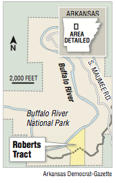
The land, known as the Roberts Tract, separates two ends of the existing trail. It contains the only feasible spot to build the about 1,600 feet needed to finish a 28-mile connecting trail, said Ross Noland, director of the foundation, a nonprofit land trust. The other 27 miles of the connecting trail are already built but haven't opened yet or been placed on maps so that people are not encouraged to trek over the private land in their quest to traverse the entire trail.
"We've got to have the Roberts Tract. It's vital to us," said Duane Woltjen, a long-time member and board member of north Arkansas conservation groups and current webmaster for the Ozark Highlands Trail Association.
The 28 miles extends the distance between U.S. 65 and Arkansas 14.
The Buffalo River Trail is part of a larger ambition to connect the Ozark Highlands Trail, beginning in Lake Fort Smith, to the imagined Ozark Trail, ending in St. Louis. The Ozark Highlands Trail has been constructed from Lake Fort Smith to Norfork, Woltjen said, and more than 300 of the 500 proposed miles of the Ozark Trail in Missouri have been completed.
Altogether, the several hundred miles of trails would be called the Trans-Ozark Trail, akin to the Appalachian Trail or the Pacific Crest Trail, although less than half the length.
One man has traversed the route, Woltjen said. He calls himself "Nimblewill Nomad," a nation-trotting, blogging backpacker who broke his leg in the middle of doing it. His given name is M.J. Eberhart, nicknamed "Eb."
Completing the trail will make it more accessible to hikers who don't wish to trespass on private property, Noland and others said.
"Hikers, unless they trespass, have to turn around and go back," Clark said.
"So it's like the transcontinental railway," Clark said, referring to the railroad that connected the eastern half of the United States to California in the 1860s via a route from Council Bluffs, Iowa, to Sacramento.
Obstacles to completing the trails in Arkansas are largely finding the resources to build them, trail advocates said. In Missouri, the trail faces similar obstacles the Arkansas conservation groups faced with the Roberts Tract -- many sections of the trail in between units of the Mark Twain National Forest are private land, Woltjen said.
If the foundation purchases the Roberts Tract, Noland said, the foundation and its partner groups would visit the land Nov. 17 to clear the remaining 1,600 feet of trail and connect it to the existing trail.
The land is a 63-acre tract between U.S. 65 and Arkansas 14 on the lower Buffalo previously owned by J.I. and Joyce Graham Roberts. The tract is at the bottom of a sharp southern dip in the river and just before it turns back north to the Maumee South launch point.
J.I. Roberts's father left it to him, and he left it to his three children when he died, according to Noland and court documents. His father, Bruce Roberts, lived in Louisiana and never built a house on the property as he had planned when he bought it in the 1960s, and his grandchildren never visited the land.
In 1983, after years of fighting a move by the federal government to condemn the land, the Robertses entered into an agreement with the U.S. that cedes some of the land to the National Park Service for a scenic easement.
The office of then-U.S. Attorney for the Western District of Arkansas Asa Hutchinson pursued the condemnation on the behalf of acting U.S. Secretary of the Interior J.J. Simonds III. The first complaint in condemnation was filed in 1979 at the request of then-Secretary Cecil D. Andrus, three years before Hutchinson was appointed U.S. attorney.
The scenic easement was a compromise, and it means nothing can be built on the land. The agreement also doesn't allow the public to enter the property.
If the foundation can buy the land, the easement goes away, Clark said.
The National Park Service would strike up an agreement with whoever would end up owning the land to have the land be preserved the same way Buffalo National River land is, Clark said.
For decades, volunteers have built the Buffalo River Trail. The Ozark Society has hosted trail building outings led by Ken Smith, author of the Buffalo River Handbook.
That's how much of the Ozark Highlands Trail was built, too, Woltjen said, recalling a period from 1999 to 2003 in which he and his wife helped build about 30 miles of the trail in the Sylamore Ranger District.
Metro on 07/16/2018