The water that flooded the Arkansas River was released from reservoirs in Oklahoma and Kansas, but there was no other choice, according to the U.S. Army Corps of Engineers.
Because of heavy rains during May, nearly 5 million acre-feet of water flowed into Oklahoma's Keystone Lake, said David Williams, chief of the Hydrology and Hydraulics Engineering Section with the Corps in Tulsa.
Six miles east of Tulsa at the intersection of the Arkansas and Cimarron rivers, Keystone Lake can hold about 1.8 million acre-feet of water, Williams said.
"There was more rainfall than available flood-control capacity in the reservoir," he said. "It does become a dam safety issue if it goes beyond that. So you have to have release."
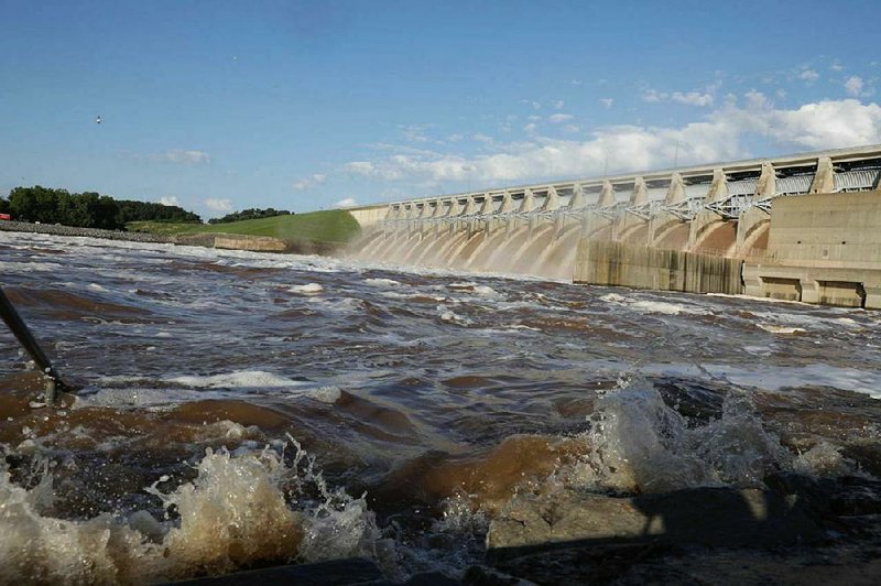
The torrential rain resulted in the release of 275,000 cubic feet per second of water from Keystone Dam for several days in a row, said Williams.
That's almost three times the flow of Niagara Falls during the tourist season.
Besides Keystone Lake, excess water also was being released from dams at two nearby Oklahoma lakes -- Fort Gibson Lake on the Grand (Neosho) River and Oologah Lake on the Verdigris River.
The Arkansas, Grand and Verdigris rivers merge just north of Muskogee, Okla., which is about 50 miles down the Arkansas River from Tulsa and upstream from the Robert S. Kerr Reservoir.
"All that water from Kansas was coming to us so we were holding a lot of water," said Brannen Parrish, a spokesman for the Corps in Tulsa. "I would like to stress, we don't flood anybody. We mitigate flooding. ... It's Mother Nature's water. We're holding it back as much as we can."
Parrish said a dam is not a guarantee of flood protection if a person lives in a flood plain.
"It is a risk-mitigation structure," he said.
Parrish said the situation would have been worse if not for dams, levees and engineers.
Tulsa engineers coordinate decisions about the release of water with engineers in the Corps' Little Rock District.
"Everything is communicated between the two of us," said Laurie Driver, a spokesman for the Corps' Little Rock District. "It is a shared system. Most everything they do affects us."
Michael Biggs, chief of the Hydraulics and Technical Services Branch of the Corps in Little Rock, said the amount of water in the Arkansas River "has fallen off directly related to the reduction of surcharge releases from the lakes in Oklahoma."
Biggs said reservoirs were still very full but areas of Kansas and Oklahoma are drying out after all the rain in May.
In Tulsa, at least for much of the year, the Arkansas River is a "prairie river, like in the old John Wayne movies," Parrish said.
"Even if Keystone weren't there, it's still a braided prairie stream," said Williams, referring to a stream bed that has several small, shallow channels of water running through it.
But that wasn't the case in May.
"There was a river all month long because we were releasing," Parrish said.
The Arkansas River changes considerably along its route.
The river begins in the Rocky Mountains near Leadville, Colo. By the time it's near Dodge City, Kan., the Arkansas River "actually becomes a disappearing stream," Williams said.
Near Muskogee, the Arkansas River intersects with the Verdigris River, which is part of the McClellan-Kerr Arkansas River Navigation System.
From there, the navigation system continues along the Arkansas River -- across Arkansas -- to the Mississippi River, providing a minimum 9-foot-deep channel for barge traffic.
The system includes 18 locks and dams that artificially deepen the Arkansas and Verdigris rivers along the entire 445-mile route, "creating a staircase from the Mississippi River up to Catoosa, Okla.," according to the Oklahoma Historical Society.
Parrish said the Arkansas River gauge at Van Buren is what they monitor to try to prevent flooding downstream. The water level at Van Buren broke a 74-year record May 31, reaching 40.79 feet. The previous record at Van Buren, 38.1 feet, was set in 1945. Major flood stage is 31 feet.
The Arkansas River also set records last week at Dardanelle, Morrilton and Toad Suck.
Williams said there are eight reservoirs in Kansas that contribute to the Arkansas River and several in Oklahoma, including Keystone, Fort Gibson, Eufaula, Tenkiller, Oologah, Hulah, Copan and Wister.
"There are a lot of reservoirs above Little Rock that contribute to the flow of the river downstream," he said.
Driver said the Arkansas River crested in Pine Bluff and Pendleton late last week. She said the crest should be out of Arkansas by the end of today.
"The crest has not moved out of the system yet so we don't want people to be complacent," Driver said Friday. "There's rain in the forecast in Oklahoma, but the weather forecast looks favorable for the next 10 days or so. I'm not sure they need to take their sandbags down yet."
"If we get 10 inches of rain really quick somewhere we didn't expect, then all bets are off," she said. "Mother Nature bets last, and she always wins."
Driver said it takes three or four days for water released from Keystone Dam to get to Van Buren, and the amount of water released at the dam was increased over a period of time.
"We knew days before this flood got here," she said. "We started talking to state officials, offices of emergency management, levee districts and the general public, telling them what was coming, and I think we did a good job of it."
"You'll not get any complaints from me about the Corps, because everything I saw convinced me the Corps was doing everything in its power to manage a system that was overcome by events, and do its best to limit the downstream impact," said U.S. Rep. Steve Womack, R-Ark. "They did a remarkable job managing through very challenging circumstances. All of the predictions that came from the Corps relative to depth and flow were pretty spot-on."
Driver said the Arkansas River was flowing at more than 500,000 cubic feet per second last week, but that had been dropping. She said the flow should be down to 200,000 cubic feet in Van Buren on Tuesday, Dardanelle on Wednesday, Pine Bluff on June 16 and Pendleton on June 17. She said the flow is expected to be down to 250,000 cubic feet per second in Little Rock by Thursday.
Womack said the flow is expected to remain at more than 150,000 cubic feet per second at Van Buren through June. He said that could limit or prevent barge traffic on the river.
Womack said the high and fast-flowing Arkansas River might have caused unforeseen damage to dams and levees. He compared it to a boxer taking punches that don't leave visible scars but could cause brain damage.
Womack said the dams and levees need to be inspected and perhaps repaired.
Gov. Asa Hutchinson wrote President Donald Trump to request a disaster declaration for the state, and Arkansas' U.S. senators and congressmen followed up Friday with a similar letter to the president. The governor said Saturday that Trump approved the request.
A disaster declaration would provide some money, Womack said, but probably not enough.
"We would still need more money from Congress," he said. "This is a long-term issue for us. ... We probably won't see normal activity on [the McClellan-Kerr Arkansas River Navigation System] for three or four months is my guess."
According to the letter sent to Trump by the Arkansas lawmakers, "Preliminary damage assessments indicate that over 857 homes have sustained major damage or were destroyed across eight counties, with many not yet experiencing the full impact of the flood waters. Out of the 1,147 homes assessed thus far, an estimated 97% are uninsured. It is also estimated that over 20% of those individuals are low income. Our citizens will be in dire need of assistance in order to regain suitable living conditions."
A Section on 06/09/2019