
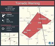
3:30 p.m.: A tornado warning is in effect until 4 p.m. today for the area around Siloam Springs and Watts and Proctor, Oklahoma, according to the National Weather Service.
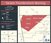
A severe thunderstorm warning is in effect until 4:15 p.m. today for Gentry, Decatur, Gravette, Sulphur Springs, Hiwasse, Bella Vista and Centerton.
12:13 p.m.: A tornado watch is in effect until 6 p.m. today for all of Northwest Arkansas, according to the National Weather Service.
Scattered showers and thunderstorms will remain possible for the area, according to a report from the National Weather Service. The bulk of the heavier rainfall and stronger storms to remain confined to eastern Oklahoma. The stronger storms that do occur will remain capable of producing heavy downpours, hail and gusty winds. Light to occasional moderate rainfall will be more common across Northwest Arkansas this afternoon.
EARLIER:
BENTONVILLE -- The first measurable precipitation of the new year will come in a one-two punch of rain and snow, a weather official said Thursday.
Widespread rain is expected today across Benton and Washington counties, said Joe Sellers, a meteorologist with the National Weather Service in Tulsa, Okla.
As the storm moves east and engulfs the state, there will be a moderate risk of tornadoes across southern Arkansas from Fouke to El Dorado, according to the National Weather Service in Shreveport, La.
Robert T. McGowen, Benton County administrator of public safety, distributed a briefing Thursday from the National Weather Service. The briefing forecasts an active weather pattern through Saturday.
A front will stretch from southeastern Oklahoma to northeastern Oklahoma and move east into Northwest Arkansas, Sellers said. Rainfall could be 2 to 3 inches, but local amounts will vary, he said. The heaviest rain is expected this afternoon and into tonight. A flash flood watch is in effect from noon today until 3 a.m. Saturday.
Thunderstorms, high wind and the possibility of hail are expected with today's rain, Sellers said. Tornadoes would be on the low end of the threats, he said.
"Nothing is out of the realm of possibility," Sellers said.

Benton County on Thursday lifted a burn ban in place since Tuesday because of low humidity and high wind, said Fire Marshal Marc Trollinger.
A cold front will follow the rain and will lower temperatures, increasing the chance for snow Saturday morning, Sellers said. The high today is forecast to be 65 degrees going steadily down to about 20 degrees Sunday morning.
Central Arkansas is expected to see significant rain and also a steep drop in temperature, but snow is not part of the weekend forecast for Little Rock and the surrounding areas.Willie Gilmore, a meteorologist with the National Weather Service in North Little Rock, said the worst of the rainfall will hit Central Arkansas around midnight and will continue through the morning. By daybreak, the heavy rain will have tapered off, he said.
Cindy Zamora of Gentry said she was concerned about possible tornadoes after two tornadoes touched down in the Siloam Springs area Oct. 21. Snow would be welcome, though, she said.
"We haven't had snow in awhile," she said Thursday.
Jay Frasier with the Benton County Road Department said crews can't treat roads before snow because rain would wash away the treatment. Crews would use sand and salt on roads between when the rain slacks and the snow starts, he said.
"It's mostly a monitoring game right now," Frasier said. "It will be a fluid effort to keep things where they need to be."
The transition from rain to snow should happen between 6 and 9 a.m. Saturday, Sellers said. Benton and Carroll counties could see up to 2 inches of snow, while Fayetteville could get about an inch, he said.
North wind will be 20 to 30 mph Saturday with gusts up to 35 mph, the briefing says. Saturday's high temperature will be in the 30s and rebound into the 40s Sunday, according to the Weather Service.
John Luther, director of Washington County Emergency Management, said Thursday morning officials were monitoring the weather.
"It's a cliche, but right now it's business as usual," he said.
NW News on 01/10/2020