LITTLE ROCK — Floodwaters receded enough to reopen the eastbound lanes of Interstate 40 on Monday, reconnecting the main thoroughfare from Little Rock to Memphis as its residents braced for the cresting Mississippi River.
The westbound lanes of the interstate remained closed Monday because that part of the roadway was still under at least 2 feet of water from the flooded White River, said David Nilles, a spokesman for the Arkansas Highway and Transportation Department.
The department had closed a 23-mile section of the interstate between Brinkley and Hazen on Wednesday, forcing westbound traffic to take a 120-mile detour through Augusta and Bald Knob and eastbound truckers to drive 300 miles through Greenville, Miss., to reach Memphis.
Galleries & Videos:
Recent flood stories & info:
“It’s pretty serious,” he said of the closure. “Interstate 40 is one of the busiest roads in the country.”
Nilles said he didn’t know when the westbound lanes would reopen. Highway officials had previously speculated the road would remain closed until at least Wednesday.
In Memphis, the Mississippi River was expected to crest at 48 feet at 7 a.m. today and remain at that level through most of the day before beginning to recede slowly Wednesday, the National Weather Service said.
Heavy rainfall in Arkansas and in the Ohio River Valley last month, coupled with runoff from melting snows farther north, has caused the river to swell.
Farther south in Louisiana, the U.S. Army Corps of Engineers officials partially opened the Bonnet Carre Spillway to ease pressure on the New Orleans levee system, The Associated Press reported. The corps last opened the spillway that diverts water from the Mississippi River into Lake Pontchartrain during the spring of 2008.
The corps also has asked for permission to open the Morganza Spillway north of Baton Rouge.
MISSISSIPPI CREST
The Mississippi River is expected to crest in Memphis less than a foot below the flooding record set there in 1937.
“We’ve got water everywhere. What a mess,” said Gene Rench, a National Weather Service hydrologist in Memphis. “We’re under the gun here.”
He said it’s likely that homes and businesses in low-lying areas of Tennesee’s Shelby County will flood as more and more backwater from the Mississippi clogs the Wolf and Loosahatchie rivers and Nonconnah Creek.
“It’s a danger that’s there. We know it’s there,” Rench explained.
Because of concerns about Nonconnah Creek, FedEx has placed a large boom called a “Tiger Dam” near its airport hub in Memphis, spokesman Sally Davenport said.
“We’re monitoring everything very closely,” Davenport said. “We’re not anticipating any emergencies based on what we’ve seen and the contingency plans we’ve made.”
Memphis officials have said about 3,000 properties will be affected, and 400 people are in shelters.
On Monday, water lapped along Riverside Drive in downtown Memphis, forcing its closure and creating a spot for gawkers to gather to watch the river’s power, said Eileen Williamson, a spokesman for the U.S. Army Corps of Engineers’ Memphis division.
“It’s a historic flood,” she said.
More than 150 corps officials check the levees constantly to ensure there’s no problems, Williamson said.
“They’re holding,” she said of the levee system. “It’s doing what it’s designed to do.”
At Gus’ World Famous Hot and Spicy Chicken restaurant on South Front Street about a block from the river, manager Mercedes Hawkins said people packed the restaurant for lunch Monday.
“Hard to tell” if the flooding concerns are affecting business, she said. “We’re always busy.”
The restaurant, along with the city’s popular night spots along Beale Street, are fine because the area is elevated, she said.
Other than the city having to relocate the annual World Championship BBQ Cooking Contest away from the river’s banks, Hawkins said, “It’s business as usual.”
Downstream in Arkansas, Desha County Judge Mark McElroy said Monday that the levees in his county were holding up well, and there was no sign of the Mississippi River flooding there.
“Everything’s good,” McElroy said. “We’re within four foot of the crest - not too much further to go.”
He said there are a few places where water is seeping under the levees but that it’s barely enough to “fill up my hot tub.”
His biggest concern now is the possibility of heavy rain to the north, which would dump more water than the swollen river could handle.
“If we can just get to the crest before it comes, that would be nice,” he said of the rain.
Forecasters are calling for a slight chance of rain Wednesday night and Thursday and a more pronounced chance this weekend, said Tabitha Clarke, a National Weather Service hydrologist in North Little Rock.
The rainfall shouldn’t cause rivers to rise, she said, but noted it may further delay the White River’s ebb.
MAIL DELIVERY
In Clarendon, the White River is forecast to crest at 37.9 feet at 7 a.m. Wednesday and remain at that level until 1 a.m. Friday before beginning to recede.
Water covering the I-40 bridge farther north has dropped more than a foot since Sunday, allowing officials to open the two eastbound lanes.
Reopening the interstate helped U.S. Post Office carriers who trucked mail daily along the 300-mile detour from Little Rock to Memphis, said Leisa Tolliver-Gay, a post office spokesman.
“They had to follow the same route the other trucks did,” she said.
Carriers have been leaving mail for residents in flooded areas at post offices, rather than delivering them to homes, she said.
“The flooding has not delayed the delivery of mail. It’s made it inconvenient,” she said.
Elsewhere, backwater from the overflowing Mississippi River is hindering the White River basin’s drainage, Clarke said.
In flat areas that are flooded, water could remain until the middle of June, she said.
Clarke flew over the White River on Friday and photographed the flooding for the National Weather Service’s website.
“In some areas, it looked like lakes,” she said. “But it was the river.”
While the White and Black rivers in north Arkansas slowly receded, the Cache River rose in Jackson County, shutting off Grubbs on three sides Monday.
A large “drift block” - a tangle of dead trees, trash and debris - has impeded the Cache River’s flow for years, causing annual flooding. That, and breaks in farm levees along the river, caused more flooding in Grubbs onMonday.
“The only way in is on Highway 18 from Newport, and we’ve got water across the road there,” Ann Norris, the city treasurer of Grubbs, said. “It’s starting to circle us.”
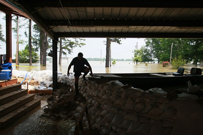
Water hasn’t reached homes, but volunteers stacked sandbags to impede the rising waters in some neighborhoods.
While the flooding has hampered thousands of Arkansans, it has provided some luck for the Southland Park Gaming and Racing in West Memphis.
The Arkansas Racing Commission allow Southland to remain open 24 hours a day, 7 days a week after the Mississippi River’s rise forced the closure of the nine casinos in Tunica, Miss., over the weekend.
The West Memphis casino had previously been open 24 hours a day only on weekends.
“We’re going like gangbusters,” said Troy Keeping, general manager of Southland.
“We’ve had an incredible volume of people.”
On Saturday, 20,000 people went to Southland, he said.
On average, 10,000 to 13,000 gamblers usually visit the casino on a Saturday.
“This has forced people to consider us,” he said. “We’re the closest alternative. We haven’t looked back since they closed [Tunica]. It’s been busy.”
Front Section, Pages 1 on 05/10/2011