LITTLE ROCK — Memphis residents were breathing sighs of relief Tuesday because the levees along the Mississippi River held off one of the highest crests on record there at 47.8 feet.
Some low-lying areas saw flooding, but not at levelsofficials had feared. The U.S. Army Corps of Engineers credited the levee system.
Galleries & Videos:
Recent flood stories & info:
“This flood is second only to the 1937flood,” spokesman Jim Pogue said. “From an engineering standpoint, we’re light-years ahead of 1937.”
The record crest in 1937 was 48.7 feet.
Residents of Arkansas and Louisiana cities along the Mississippi River are awaiting the crest, now making its way south toward the Gulf of Mexico.
Already, Arkansas com-munities are grappling with flooding losses that have damaged hundreds of homes, some with stagnant water up to the eaves.
The flooding also has strained Entergy Corp.’s fourstate electrical service.
“It’s important that our customers are aware that we could face power shortages until these conditions improve,” Hugh McDonald, Entergy Arkansas’ chief executive officer, said in a prepared statement.
Arkansas did get some good news Tuesday: Water over the westbound lanes of Interstate 40 appears to be dropping. Highway officials hoped to have the westbound lanes reopened soon.
MEMPHIS
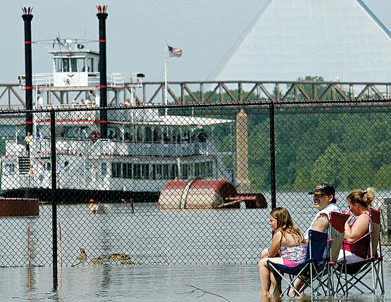
By Tuesday afternoon in Memphis, only a few clusters of people lined Riverside Drive downtown to gawk at the swollen river. A small portion of Beale Street was submerged at Riverside Drive, but just a block away, the popular stretch of bars and restaurants bustled as usual.
Locals scoffed at the national media that had descended on the city.
“I don’t know what they think they’re going to get,” one restaurant patron said to his dining companion as he watched a television camera crew walk past the window.
On Mud Island, the Mississippi had encroached on some of Harbortown’s parks and riverfront property, although joggers and dog walkers continued unfazed.
Their complacency irked residents who saw their homes flooded in low-lying pockets throughout the city and Shelby County, which President Barack Obama declared a federal disaster area Tuesday.
“That torqued me, when I saw [Harbortown] this morning,” said Kathy Warden, whose daughter, son-in-law and grandchildren have been displaced by flooding at Memphis Mobile City, where about 150 mobile homes sit.
The community resembled a lake, with most of its trailers submerged in at least 6 feet of water. The Hissongs evacuated April 30, after packing up all of the family’s belongings.
Only the top of a swing set and slide were visible Tuesday when they dropped by.
“I’ve lived in this neighborhood all my life,” Daryl Hissong said. “This is as high as I’ve ever seen it.”
‘RIVER IS A MONSTER’
Desha County Judge Mark McElroy led a prayer Tuesday during a meeting in Arkansas City, asking God to keep his community safe.
On Tuesday afternoon, the river sat at just more than 51 feet at Arkansas City and is expected to crest at 53.5 feet Sunday, according to the National Weather Service in North Little Rock.
“God, we know you parted the Red Sea, and we know you are the only one who can keep the Mississippi River from breaching our levee,” McElroy said.
After his prayer, McElroy told the dozen or so people gathered to spread calm throughout the community of 500 residents.
“Right now the Mississippi River is a monster. And our levee is keeping that monster at bay.”
Arkansas House Speaker Robert S. Moore Jr., D-Arkansas City, also tried to reassureresidents.
“I am sleeping real good at night,” Moore said. “I’m not packing anything up, and I’m not planning to leave.”
Meanwhile, Desha County sheriff Chief Deputy Larry Allen patrolled Great River Road, which runs atop the levee. In the distance, the Big River, as locals affectionately call it, roared.
“There’s plenty of levee here to stop this water,” Allen said.
Just in case, though, evacuation plans are in place if the need arises, he added.
“Right now everyone is pretty calm around here,” he said. “This is just part of life on the river.”
Farther south in Chicot County, officials were closely monitoring several sand boils near the levee at Lake Village. The effect is caused by a difference in pressure on two sides of a levee during a flood and can cause a levee breach.
About 117 miles upriver in Helena-West Helena, officials also were keeping an eye the levee system, though no problems had been reported, according to the Phillips County Office of Emergency Management.
As the state waits to see what happens with flooding along the Mississippi River, officials continued to work to get Arkansans federal disaster-relief assistance. The Federal Emergency Management Agency announced Tuesday that Boone, Jefferson and White counties had been added to the list of counties designated for federal individual assistance since storms hit the state April 23.
“We’re happy that assistance to individuals and families will soon be on the way to eligible Arkansans in three more of our counties,” said David Maxwell, head of the state’s Department of Emergency Management.
‘VERY, VERY LUCKY’
After weeks of concern, the White River has finally crested at all points in Arkansas, said Tabitha Clarke, a hydrologist with the National WeatherService in North Little Rock.
For residents of Clarendon in Monroe County, that’s a blessing.
“We are very, very lucky,” Clarendon Mayor Jim Stinson III said. “We don’t have any damage whatsoever. We don’t have any leakage. No breaks, nothing.”
However, the water is affecting the flood plain and farmland.
Clarke said the river hit 37.53 feet in Clarendon, and that’s considered “a major flood.”
The White River had been expected to crest Tuesday at Clarendon at 38 feet. Stinson, who has lived there since 1969, said no one had seen it get that high.
“We were concerned what it would do to the levee,” Stinson said. “I honestly believe we could withstand 4 or 5 more feet of water.”
Stinson said he knows other towns along the White River haven’t been as lucky.
Floodwaters are creeping ever closer to several houses and trailers that sit 400 yards from the end of the city’s levee. One trailer and two houses had already taken in water Tuesday, and about 20 people were piling up sandbags to save the others.
In southern Monroe County, floodwaters from the White River consumed the rural communities of East Lake, Maddox Bay, Green Lake and Indian Bay along with thousands of acres of farmland, County Judge Larry Taylor said.
Those communities, just downriver from Clarendon, are not protected by a levee. About 750 homes took on water, some up to the roofs.
Taylor, who has lived in that county for 60 years, attributed the lack of fatalities to ample warning. “[The flood of] ’73 was the worst I’d ever seen. This beats ’73.”
LOUISIANA, MISSISSIPPI
In Louisiana, Gov. Bobby Jindal said Tuesday that communities along the Morganza spillway should be prepare for evacuations. He expects a decision from the Army Corps of Engineers soon on opening the spillway, a relief valve for the swollen Mississippi River.
The governor said the latest projection was for an opening as early as Saturday. Pam Vidros, a spokesman for the Corps, said a decision is likely in the next couple of days.
In Mississippi, widespread flooding is expected along the Yazoo River, a backed-up Mississippi River tributary.
Farmers built levees to protect their corn, cotton, wheat and soybean crops, but many believed the crops would be lost entirely.
Mississippi’s key gambling industry was taking a hit, too. All 19 casinos along the river were to be shuttered by week’s end, losing governments about $12 million to $13 million in taxes per month.
Nearly 600 households had suffered water damage, said Greg Flynn, a spokesman for the state emergency-management agency.
In Vicksburg, the river was forecast to peak slightly above the record set during the flood of 1927. Some places were already several feet underwater, and the river wasn’t expected to peak there until Saturday.
Wearing rubber boots and watching fish swim up and down his street, William Jefferson stood on a high spot inhis neighborhood, inundated with at least 3 feet of water. Nearby, his brother Milton cast a fishing rod.
“At least we can catch something fresh to eat, because we ain’t got no icebox or electricity,” he said with a smile.
Information for this article was contributed by Holbrook Mohr and Shelia Byrd of The Associated Press.
Road closings The list below shows Arkansas roads closed because of high water or washouts as of Tuesday afternoon. Up-to-date listings can be found under “fl ood information” at www.arkansashighways.com Road Location ARKANSAS COUNTY Ark. 1 Bridge at the Arkansas/Monroe county line Ark. 17 Mile 9.89 to 14 at Ethel Ark. 144 Mile 0.20 to 1.08 near Gillett BENTON COUNTY Ark. 264 Section 1 east of Bethel Heights CARROLL COUNTY Ark. 187 Section 0A at Beaver CONWAY COUNTY Ark. 95 Mile 2.85 at Morrilton CRAIGHEAD COUNTY Ark. 158 Intersection of Ark. 139 to Mississippi Co.
Ark. 230 At Bono CRITTENDEN COUNTY Ark. 118 Mile 12.4 at Earle Ark. 184 Mile 2.9 CROSS COUNTY Ark. 42 Between Ark. 163 and Ark. 75 Ark. 163 Two miles south of U.S. 64 at mile 0.15 near Levesque GREENE COUNTY Ark. 139 U.S. 412 to Mounds INDEPENDENCE COUNTY Ark. 14 Mile 1.2 to 5.81 east of Oil Trough Ark. 37 Ark. 122 to Jackson Co.
JACKSON COUNTY Ark. 14 Mile 0 to 3.94 at Macks Ark. 18 Section 1 from junction of 18 spur to Poinsett Co.
Ark. 37 Mile 0 to 7.96 near Tuckerman Ark. 384 Mile 1.09 to 9.15 near Newport LAWRENCE COUNTY Ark. 228 Mile 0 to 4.5 at Clover Bend U.S. 412 Section 6A west of Walnut Ridge LEE COUNTY Ark. 44 N Bear Creek State Park entrance Ark. 78 Mile 0 to 4.3 near Aubrey U.S. 79 Mile 1.5 north of Marianna Ark. 121 Mile 7.19 near Holub Ark. 121 Mile 7.5 at Marianna Ark. 243 West of Ark. 121 near Rondo LONOKE COUNTY Ark. 13 5 miles north of Carlisle Ark. 13 Between Daniel Rd. and Ark. 232 Ark. 381 Mile 0.88 MISSISSIPPI COUNTY Ark. 118 Mile 0 to 2.75 at Joiner Ark. 120 Between Tuckertown and O’Donnell Bend Ark. 158 Mile 0 to 3.0 at Mandalay Ark. 198 From the Mississippi River levee to the end of state maintenance MONROE COUNTY Ark. 1 Bridge at Arkansas/Monroe county line to Marvel Ark. 17 South of Holly Grove Ark. 146 Mile 0 to 9.6 near Lawrenceville Ark. 146 Mile 0 to 9.86 near Holly Grove Ark. 302 Mile 0 to 6.5 near Clarendon PHILLIPS COUNTY Ark. 20 Mile 18 at Helena Ark. 85 Between U.S. 49 and Ark. 44 Ark. 146 Mile 0 to 5.35 Ark. 318 Between Ark. 85 and Ark. 44 Ark. 318 Ark. 316 to Ark. 20 POINSETT COUNTY Ark. 373 From Stewart to Ark. 163 PRAIRIE COUNTY I-40 Westbound at the 202 mile marker Ark. 33 South of Ark. 38 at Des Arc Ark. 38 Mile 16.96 to 20.35 at Des Arc Ark. 38 Junction Ark. 11 south of Searcy and north of Des Arc Ark. 38 Junction Ark. 11 at mile 3.99 U.S. 70 West from Ark. 33 to the White River bridge toward DeValls Bluff RANDOLPH COUNTY Ark. 90 U.S. 67 to O’Kean Ark. 304 Between U.S. 67 and Ark. 231 ST. FRANCIS COUNTY Ark. 50 Mile 0.5 north of Madison Ark. 50 Mile 1.0 U.S. 70 Between Ark. 50 and Ark. 38 WHITE COUNTY Ark. 36 Mile 8.03 east of West Point SOURCE: Arkansas Highway and Transportation Department Arkansas Democrat-Gazette
Front Section, Pages 1 on 05/11/2011