1:43 p.m. update
The National Weather Service in Little Rock has canceled the tornado watch for most of central Arkansas.
A storm moved through the region about 1:10 p.m. Thursday, and a severe thunderstorm warning was issued for the area. It was also canceled by the weather service, at 1:13 p.m.
The tornado watch was canceled for Cleburne, Dallas, Faulkner, Grant, Ouachita, Pulaski, Saline and Sharp counties at 1:41 p.m. The watch continues for a large chunk of eastern and southeastern Arkansas, including Arkansas, Bradley, Calhoun, Cleveland, Desha, Drew, Independence, Jackson, Jefferson, Lincoln, Lonoke, Monroe, Prairie, White and Woodruff counties. That watch extends until 5 p.m.
Meanwhile, a significant weather advisory is in effect for Cleveland, Dallas, Jefferson and Lincoln counties until 2:15 p.m.
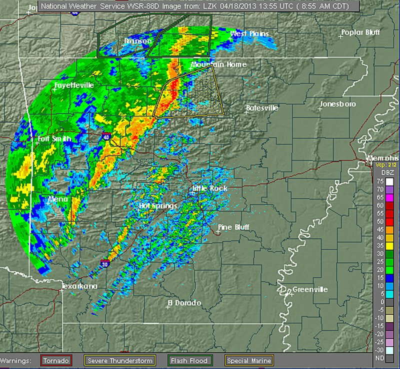
10 a.m. update
A tornado watch is in effect for much of central, eastern and south Arkansas as a line of thunderstorms passes through the state, the National Weather Service said Thursday morning.
The watch, in effect until 5 p.m., covers the following counties: Arkansas, Baxter, Bradley, Calhoun, Clark, Clay, Cleburne, Cleveland, Conway, Craighead, Crittenden, Cross, Dallas, Desha, Drew, Faulkner, Fulton, Garland, Grant, Greene, Hot Spring, Independence, Izard, Jackson, Jefferson, Lawrence, Lee, Lincoln, Lonoke, Mississippi, Monroe, Montgomery, Ouachita, Perry, Phillips, Pike, Poinsett, Pope, Prairie, Pulaski, Randolph, Saline, Sharp, St. Francis, Stone, Van Buren, White and Woodruff.
The line of storms will be in east Arkansas by the afternoon and will cross the Mississippi River by early evening, the weather service said.
"A few tornadoes will be possible, with the greatest chances for tornadoes east of a line from Monticello to Lonoke to Searcy to Pocahontas this afternoon," weather service Warning Coordination Meteorologist John Robinson said in a statement. "One or two tornadoes will have the potential to reach EF2 or greater intensity."
Rainfall totals will average 1 to 2 inches, Robinson said, with some areas seeing at least 3 inches.
Earlier story
Severe storms are expected Thursday throughout Arkansas as a storm system and cold front gradually make their way through the state.
The National Weather Service says isolated tornadoes and damaging winds are possible ahead of and along the cold front. The Storm Prediction Center in Norman, Okla., says western Arkansas is at a slight risk for severe weather, while the central and eastern parts of the state are at a moderate risk.
The National Weather Service says "torrential downpours" are possible Thursday but widespread flooding is not expected.
However, a flood warning has been issued for the Ouachita River at Thatcher Lock and Dam near Calion.
Unseasonably low temperatures will settle in after the storm system leaves Arkansas. Forecasters say some areas in Northwest Arkansas could approach freezing early Friday.
INTERACTIVE GRAPHIC
Information for this article was contributed by The Associated Press.