Officials shored up Red River levees in south Arkansas, and residents prepared for yet another rise in the Arkansas River on Monday as water from Oklahoma and Texas continues to flood both rivers.
The Red River at Fulton is expected to crest at 32 feet Thursday afternoon, 5 feet above flood stage and the highest mark at the Hempstead County gauge since 1990, when flooding ravaged the area.
However, some fear that the river may get higher than a quarter of a century ago if U.S. Army Corps of Engineers officials continue releasing more water from overflowing Oklahoma lakes and reservoirs into the Red River basin. Water at the Denison Dam at Lake Texoma in Kingston, Okla., poured over the spillway and was at the highest level since 1944, when the dam was built.
The dam was releasing water at 139,000 cubic feet per second Monday morning, Lake Texoma Park Manager Joe Custer said. "It's an historic event," he said. "We set a record today for the most water, and a lot of people are coming to see the water."
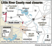
Downstream in Arkansas, Corps officials and emergency managers conducted constant evaluations of the 40 miles of levee system along the Red River in Miller and Lafayette counties.
Lafayette County County Judge Mike Rowe said workers used 1,700 cubic yards of clay material to build up low spots in the levee caused over the years by wear from farm vehicles, cattle and other traffic.
"We're doing daylight patrols of the levees and not finding any problems," Rowe said. "But we're expecting 3 or 4 more feet of water in the next few days."
Rowe said he was concerned that if more water was released from Oklahoma, the water level could eventually top the levees.
"Our people are focusing on the water level in Fulton and comparing it to 1990," he said.
The river reached 34.3 feet at Fulton on May 12, 1990, setting a benchmark for flooding problems.
"The river rose 8 inches in the last 12 hours," Michelle Richardson, a member of the Lafayette Office of Emergency Management, said of the Red River level at Garland. The office has a command post set up at the Miller County town.
"We have patrols of the levees every 30 minutes to an hour," she said. "We're praying they hold up."
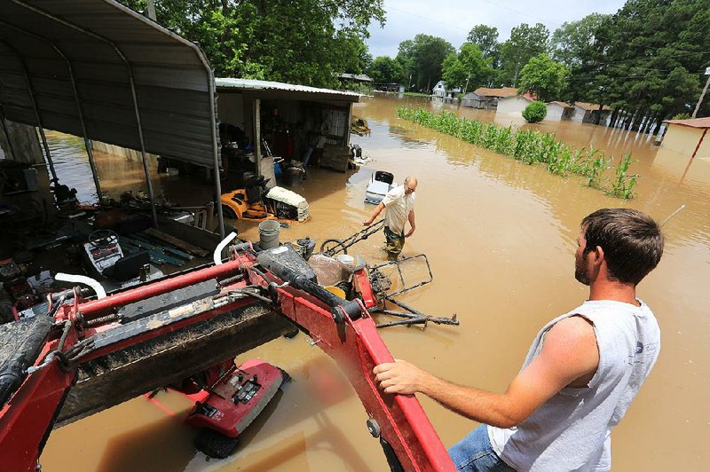
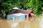
Teams put sand bags along low places in the levees and checked for any seepage Monday. The river water entered the West Shore Restaurant in Garland over the weekend and continues to rise, she said. At least 4 feet of water stood in the Boll Weevil, a liquor store in Fulton.
"At this point, we've done all we can do," she said. "We're praying [the levees] continue to hold. If they release any more water, there's always a chance it could go over the levees."
Custer said about 5 feet of water continued cascading over the 17,200 foot dam at Lake Texoma on Monday morning. Further downstream, other lakes were also releasing water into the Red River.
"We waited for a long time before we finally had to release water," Custer said. "It's going to be a long period before we get an opportunity to get rid of all the flood water."
Reservoirs in the Arkansas River basin in Oklahoma are 97 percent full, said National Weather Service hydrologist Tabitha Clarke of North Little Rock. On Friday, several lakes, including Eufaula Lake, released water into the Arkansas River, sending a second wave downstream.
More 15 inches of rain fell in Oklahoma and Texas last month, filling reservoirs to capacity.
"There's still way too much water in Oklahoma," Clarke said "If they get any more rain, it'll go over the spillways. They've got to manage their water there and control it. It will be a slow downfall, and river flow rates will be high for several more weeks."
In Little Rock, the Arkansas River raged at 340,000 cubic feet per second Monday afternoon. The average flow of the river is between 40,000 and 50,000 cubic feet per second. The river flowed at 320,000 cubic feet per second at Van Buren on Monday.
Laura Smith, the office manager at Cajun's Wharf, a Little Rock restaurant on the Arkansas River shoreline, said diners have been amazed at the river.
"You can see it going really strong," she said of the current. "It's a talker. All we can see are the tops of trees where we used to be able to see most of the trees before."
Seven locks and dams were closed Monday because of the high waters including Fort Smith, Morrilton, Toad Suck, Scott, Tucker, Pine Bluff and Grady.
"We're expecting the wave of water from Oklahoma to make its way down the Arkansas River again," said Corps spokesman Laurie Driver of Little Rock.
In Morrilton, the river is expected to crest at 39.2 feet tonight, the seventh highest mark ever there.
The river will crest in Pine Bluff on Thursday morning at 46 feet, the fifth highest recorded there. Flood stage in the Jefferson County town is 42 feet.
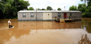
More than 80 homes in Pine Bluff had water in them Monday, said Karen Blevins, the coordinator of the Jefferson County Office of Emergency Management. Some homeowners saw water reaching 2 feet deep inside their houses, she said.
"People thought the water was coming back down last week," she said. "Then it came back up and caught a lot of people by surprise. This is going to be a slow process going down.
"This is the worst I've ever seen it," she said.
Many of the flooded homes are in Harbor Island Estates, Knots Island Road, Swan Lake and Reydell.
Several residents chose to remain in their homes, living on second floors, rather than leaving, Blevins said. Still, rescue teams did make several boat rescues over the weekend, including one from a recreational vehicle park along the Arkansas River.
County officials opened a shelter in Pine Bluff for those displaced.
The American Red Cross has also opened shelters at the Swan Lake Fire Station in Altheimer, the Wright-Pastoria Volunteer Fire Department in Wright, the Grand Avenue Baptist Church in Fort Smith and the Beech Street Baptist Church in Texarkana.
Weather service forecasters said sunny skies should prevail across the state for at least seven days, giving the rivers some chance to recede.
"It's going to provide a lot of relief," Clarke said. "We may see a couple of minor fronts coming in later this week, but there won't be the moisture plume we had before. It will be better for us."
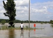
Monday's sunshine brought out sightseers. Hundreds of people parked near the Arkansas 82 bridge between Garland and Lewisville to gawk at the raging Red River, Lowe said.
On Monday, the Arkansas Highway and Transportation Department placed flashing road signs near the bridge advising motorists not to park alongside the roadway and walk onto the bridge to take photographs.
"It's dangerous," Rowe said. "We're having enough problems. When the sun came out, the people came out.
"But the sun is good," he said. "Every day we have sunshine is a good day now."
State Desk on 06/02/2015