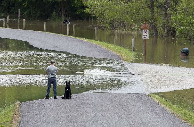
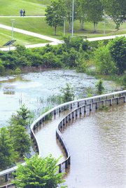
The flooded Arkansas River crested at Little Rock on Wednesday afternoon, swamping the city's River Trail and a nature center's wetlands, and Pine Bluff residents prepared for the rising water to come.
The U.S. Army Corps of Engineers shut down operations at the Emmett Sanders Lock and Dam near Pine Bluff on Wednesday morning. Two other locks and dams -- at Toad Suck and Morrilton -- remained closed because of the rapid water.
Heavy rains over the weekend and Monday in the Arkansas River Valley sent cascades of runoff into the Arkansas River, causing the waterway to flood. Fort Smith reported 9 inches of rain over a 96-hour period.
"The river is designed for navigation," Corps of Engineers spokesman Laurie Driver said. "There's no place to hold water on the Arkansas River. It is an open river, and the water moves on down."
The river crested at 20.25 feet in the capital city at 1 p.m. Wednesday. Flood stage there is 23 feet.
The Arkansas River Trail, a miles-long scenic walkway in Little Rock and North Little Rock, remained closed because of the flooding Wednesday. Up to 8 feet of water soaked the wetlands along the river at the Witt Stephens Jr. Central Arkansas Nature Center near downtown Little Rock.
"We heard it was going to crest Tuesday night, but the water kept coming up," said Lauren Marshall, the museum program director at the nature center. "It's up to the rafters over the boardwalk."
Not everyone lamented the flooding, she said.
"We've seen plenty of muskrats swimming around, and turtles and birds," Marshall said. "There's plenty of wildlife. They wait for something to float downstream -- fish or seaweed -- and they grab it and eat it."
In Pine Bluff, 3 feet of water covered the road leading to Jim Thomas' Island Harbor Marina.
"You can't drive out here, you can make it by boat," Thomas said. "If you can get here, I'll sell you a soda pop."
The Arkansas River is expected to crest in Pine Bluff at 42.7 feet this morning, reaching the 10th-highest level recorded. Flood stage is 42 feet.
"I can see telephone poles, trees, all kinds of stuff coming down," Thomas said of debris in the river.
Officials closed the Pine Bluff Regional Park on Wednesday because up to 4 feet of water covered the park's amphitheater, said Trudy Redus, the Saracen Landing manager with the city's Parks and Recreation Department.
"It's bad," Redus said. "Just bad. The amphitheater has metal seats, so it should be OK once the water recedes. But there will be a lot of cleanup."
The Harbor Oaks Golf Club in Pine Bluff canceled a tournament scheduled for Wednesday because of the rising water.
National Weather Service hydrologist Tabitha Clarke of North Little Rock said the Arkansas River should drop below 40 feet at Pine Bluff by Saturday morning.
"The water is receding in the west and making its way downstream," Clarke said. "At least the Mississippi River is low-falling. That's a positive side. It allows the water a way to get out of here. There's no backwater to stall things."
The Corps issued a small-craft advisory Friday because of dangerous conditions on the turbulent Arkansas River. Normally, the river flows at a rate of 30,000-50,000 cubic feet per second at Little Rock. On Wednesday, it raged at 300,000 cubic feet per second.
"It changes by the hour," Driver said. "We are seeing significant drops behind the crest."
Scott Fryer, the park manager at the Corps' facility in Russellville, said the Arkansas River dropped 7-8 feet Wednesday, and workers were busy cleaning up debris and silt left by the receding river.
On Tuesday, "thousands and thousands" of sightseers crowded the road along the river to watch the raging water, he said.
"There was a lot of whitewater flowing. It looked like the Snake River," Fryer said, referring to a scenic river in the northwest U.S. that's popular with rafters. "It was a pretty impressive sight."
Although most of the flooding is expected to ease by the weekend, Corps officials are watching the controlled release of water along the Arkansas River farther west in Oklahoma. That, coupled with a forecast that calls for several days of rain ahead, could affect river levels again.
Rain showers are expected in the state today and through the weekend, Clarke said. Another larger system should slowly cross into the state early next week, bringing more rainfall.
Clarke said early forecasts indicate more heavy rain in the southwestern corner of the state that will effect the Ouachita River basin more than the Arkansas River.
"The Arkansas River will continue to recede, but there are dams in Oklahoma that are full and releasing water, and if it rains there, too, we won't have much time for the river to get too low," she said.
State Desk on 05/14/2015