The Trail of Tears has footsteps across Benton and Washington counties, and one group wants to ensure those steps are not forgotten.
"We are working with the U.S. National Park Service to specifically mark the Trail of Tears route through the two counties," said John McLarty, project manager for the Trail of Tears Association's Arkansas Chapter.
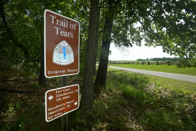
The signs are designed by the Park Service and purchased through the Park Service's National Historic Trail Division, McLarty said.
Cherokee Nation Secretary of State Chuck Hoskin, in a statement, expressed support for the signs.
"The Cherokee Nation supports enhancing historic signage along the Trail of Tears routes in Arkansas if it brings more awareness and education about our forced removal. We commend the National Park Service and National Trail of Tears Association, as well as the Arkansas chapter, for continuing to research the routes and places that centered on this dark chapter in our history," Hoskin said.
The initiative is statewide but will begin with placing markers at specific locations in Northwest Arkansas. The purpose is to remind people of the trail's complex history, McLarty said.
The federal government forced the Cherokee to move from their homes in the Appalachians to Indian Territory, which is now Oklahoma.
"The story of the Cherokee is one of determination, perseverance and rebuilding," McLarty said. "They would have preferred to stay in the Appalachians, but they are actually thriving in Oklahoma."
The signs will be placed along roadways, in parks and on parts of the Razorback Greenway. McLarty hopes the first three signs will be placed in Pea Ridge National Military Park by June 20, which is when the Remember the Removal bike team will ride through the park. The team rides the Trail of Tears' northern route in remembrance of the forced removal.
Kevin Eads, superintendent of the National Military Park, welcomes the new signs and the association's efforts.
"They're great partners, and we've really enjoyed working with them," Eads said. "I'm excited about getting some additional signs."
The military park has signs that indicate trail distance, Eads said.
"We're supplementing those. There'll be more of them and they will be at some key locations," Eads said.
About 200 to 300 signs will be placed along the trail, and about 50 to 80 will be in Northwest Arkansas, McLarty said. It's unknown what the total project cost will be, he said.
The Park Service placed Trail of Tears signs in the 1990s, but those were for the Auto Tour route along numbered state and federal highways approximate to the actual trail. That route was done because it was more efficient to get permission to put up the signs from state highway departments, and also because research to identify a historic route was not complete, McLarty said.
"So much research has been done in the last eight to 10 years that the National Park Service has determined that they can identify and sign a more accurate route closer to the original route," McLarty said. "Now that we know enough of the original route, it's worth the effort to go to the meetings with cities and the counties."
The new signs will be for a historic route, on the actual paths that the Cherokee walked, said Cory Donnelly, landscape architect for National Trails Intermountain Region, a Park Service program.
"Our initiative, our focus, has changed in recent years. We are focused on signing the historic route," Donnelly said. "The Auto Tour route still exists, but we have found it's more powerful to have a historic route."
The Auto Tour signs will remain, Donnelly said.
The Park Service will place Trail of Tears signs in all nine states the historic trail runs through, working with partners that range from city to county municipalities to private citizens, Donnelly said.
Arkansas will be one of the first states to install the historic route signs, which will be placed on county roads, city streets and highways, McLarty said.
"Our project will take longer to get all the permissions," he said. "Every city it goes through, we'll need permission from that city. It's a lot of leg work. It's a two- to three-year project."
Some of the roads that made up the trail include Old Missouri Road in Springdale and Fayetteville and Old Wire Road in Fayetteville and Rogers, McLarty said.
While the Park Service will pay for some of the signs, the association will raise the rest of the money from historical societies, chambers of commerce and various other sources, McLarty said.
Metro on 06/05/2017